Jerome is a town in the Black Hills of Yavapai County in the U.S. state of Arizona. Founded in the late 19th century on Cleopatra Hill overlooking the Verde Valley, Jerome is more than 5,000 feet (1,500 m) above sea level. It is about 100 miles (160 km) north of Phoenix along State Route 89A between Sedona and Prescott. Supported in its heyday by rich copper mines, it was home to more than 10,000 people in the 1920s. As of the 2020 census, its population was 464.

Black Hawk is a home rule municipality located in Gilpin County, Colorado, United States. The population was 127 at the 2020 United States Census, making it the least populous city in Colorado. It was a mining settlement founded in 1859 during the Pike's Peak Gold Rush and is now a part of the Denver-Aurora-Lakewood, CO Metropolitan Statistical Area and the Front Range Urban Corridor.

Butte is a consolidated city-county and the county seat of Silver Bow County, Montana, United States. In 1977, the city and county governments consolidated to form the sole entity of Butte-Silver Bow. The city covers 718 square miles (1,860 km2), and, according to the 2020 census, has a population of 34,494, making it Montana's fifth-largest city. It is served by Bert Mooney Airport with airport code BTM.

ASARCO is a mining, smelting, and refining company based in Tucson, Arizona, which mines and processes primarily copper. The company has been a subsidiary of Grupo México since 1999.
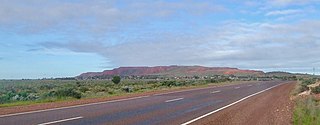
Iron Knob is a town in the Australian state of South Australia on the Eyre Peninsula immediately south of the Eyre Highway. At the 2006 census, Iron Knob and the surrounding area had a population of 199. The town obtained its name from its proximity to large deposits of iron ore, most notably Iron Monarch which outcropped prominently from the relatively flat, surrounding landscape.

Captains Flat is a town in the Southern Tablelands of rural New South Wales, Australia, in Queanbeyan-Palerang Regional Council. It is south of Queanbeyan. Captains Flat township is bounded by the non-urban parts of the locality of Captains Flat in the north, east and west, and Captains Flat Road, the Molonglo River and Foxlow Street in the south.
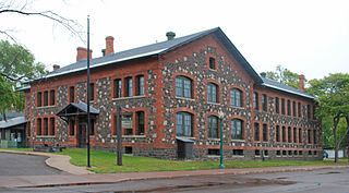
Keweenaw National Historical Park is a unit of the U.S. National Park Service. Established in 1992, the park celebrates the life and history of the Keweenaw Peninsula in the Upper Peninsula of the U.S. state of Michigan. It is a federal-local cooperative park made up of two primary units, the Calumet Unit and the Quincy Unit, and almost two dozen cooperating "Heritage Sites" located on federal, state, and privately owned land in and around the Keweenaw Peninsula. The National Park Service owns approximately 1,700 acres (690 ha) in the Calumet and Quincy Units. Units are located in Baraga, Houghton, Keweenaw, and Ontonagon counties.
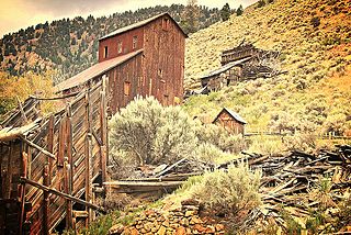
Bayhorse is a ghost town in Custer County, Idaho, United States, founded in 1877, though active development of the town did not begin until 1880. Bayhorse was once a thriving mining town, principally supported by large nearby silver deposit. In 1882, the town increased its smelting capabilities, producing $300,000 worth of silver over the course of the year. By 1885, the town had grown to 300 residents, supported by a mill, three stores, a hotel, a restaurant, a meat market, a lodging house, and five saloons. The same year, the town built a refinery, allowing the mining industry to issue silver bars and by 1900, the town had extracted over $10 million in total ores, including silver, lead, and copper.

Sewell is a populated Chilean mining town located on the slopes of the Andes in the commune of Machalí in Cachapoal Province, Libertador General Bernardo O'Higgins Region, at an altitude of between 2,000 and 2,250 metres. In 2006, it was designated as a UNESCO World Heritage Site. It is known as a former company town, developed by Braden Copper Company for housing the workers associated with the operations of El Teniente, the largest underground copper mine in the world.

Central Idaho is a geographical term for the region located northeast of Boise and southeast of Lewiston in the U.S. state of Idaho. It is dominated by federal lands administered by the United States Forest Service and the Bureau of Land Management. Idaho's tallest mountain, Borah Peak, is located in this region. A large part of the Sawtooth National Recreation Area is within Central Idaho.
Mount Sicker is in southern Vancouver Island, British Columbia. The twin summits of Big Sicker Mountain, at 716 metres (2,349 ft), and Little Sicker Mountain, at 660 metres (2,170 ft), are near Crofton, Chemainus and Duncan.

The Silver Valley is a region in the northwest United States, in the Coeur d'Alene Mountains in northern Idaho. It is noted for its mining heritage, dating back to the 1880s.

Sasco is a ghost town located in Pinal County, Arizona, west of Red Rock. Sasco, which is an acronym for the Southern Arizona Smelter Company, was a company town with a large smelter that served several mines. Once an impressive and little-known ghost town, today Sasco is a common sporting destination with shotgun shells, airsoft bb's, paintball splatter, and litter in the area.
Granby Consolidated Mining, Smelting and Power Co. was established by charter to operate in the Boundary region of southern British Columbia. Primarily involved in the mining and smelting of copper, the conglomerate became a publicly traded company. The various corporate operating names within the former group mostly specified the Granby identity.

Bristol Wells, also known as National City, Bristol City and Tempest, is a ghost town in Lincoln County, Nevada. The mining town was located on the west side of Bristol Mountain, 14 miles (23 km) northwest of Pioche, Nevada.
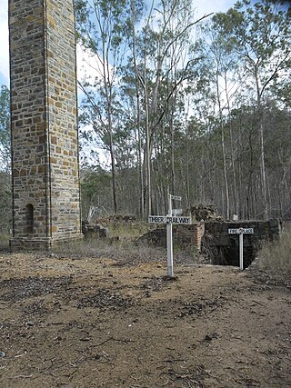
Mount Clara smelter is a heritage-listed former copper smelter at Rossmore Road, in the upper reaches of Fat Hen Creek, Oakview, Gympie Region, Queensland, Australia. It was built in 1873. It was added to the Queensland Heritage Register on 21 October 1992.
The Ferris-Haggerty Mine Site was one of the richest components of the Grand Encampment Mining District in Carbon County, Wyoming. The site was first exploited by Ed Haggerty, a prospector from Whitehaven, England, in 1897 when he established the Rudefeha Mine that would later be known as the Ferris-Haggerty Mine on a rich deposit of copper ore. Haggerty was backed by George Ferris and other investors, of whom all but Ferris dropped out. The partners sold an interest to Willis George Emerson, who raised investment funding for improvements to the mine. These facilities included an engineering feat of its day by developing a 16-mile (26 km) aerial tramway to carry high grade copper mined at the Ferris-Haggerty Mine (FHM) over the Continental Divide to the smelter in Encampment. The tramway was longest aerial tramway the world had ever seen. The mine was eventually acquired by the North American Copper Company for $1,000,000 Million. By 1904 the mine had produced $1.4 million in copper ore, and was sold to the Penn-Wyoming Copper Company. However, even with copper prices peaking in 1907, the company had difficulty making a profit from the remote mine site. The company was over-capitalized and under-insured and was suffered devastating fires at the mine site in March 1906 and May 1907 which halted production. Business disputes and a fall in copper prices prevented re-opening of the mine even after it was rebuilt. Machinery was salvaged after a foreclosure in 1913. A total of 23 million pounds of copper ore was extracted from the mine during its life.

The Britannia Mines Concentrator is a National Historic Site of Canada. The large, inclined gravity mill was built on the northwest side of Mount Sheer to assist the transfer of copper ore through the chemical and mechanical processes of the plant. It is a landmark in Britannia Beach, British Columbia some forty-five kilometers north of Vancouver.

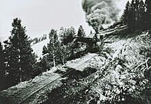
The electric railway of the White Knob Copper Co., Ltd. was operated by the White Knob Copper Co. at White Knob near Mackay, Idaho, in connection with its mines, having 7.1 miles (11.4 km) of railroad, two electric locomotives and 40 ore cars. The difference in level over the seven miles was 2,100 feet (640 m), an average of 6 per cent. Eighty tons of ore were handled by each train.