
Bismarck is the capital of the U.S. state of North Dakota and the county seat of Burleigh County. It is the state's second-most populous city, after Fargo. The population was 73,622 at the 2020 census, and was estimated to be 75,092 in 2023, while its metropolitan population was 133,626. In 2020, Forbes magazine ranked Bismarck as the seventh fastest-growing small city in the United States.

Walworth County is a county in the U.S. state of South Dakota. As of the 2020 census, the population was 5,315. Its county seat is Selby. The county was created in 1873 and organized in 1883. It is named for Walworth County, Wisconsin.

Minnehaha County is a county on the eastern border of the state of South Dakota. As of the 2020 census, the population was 197,214, making it the state's most populous county. It contains over 20% of the state's population. Its county seat is Sioux Falls, South Dakota's most populous city. The county was created in 1862 and organized in 1868. Its name was derived from the Sioux word Mnihaha, meaning "rapid water," or "waterfall".
Lincoln County is a county in the U.S. state of South Dakota. As of the 2020 census, the population was 65,161, making it the third most populous county in South Dakota. Its county seat is Canton. The county was named for Abraham Lincoln, 16th President of the United States. Lincoln County is included in the Sioux Falls, SD, Metropolitan Statistical Area. It is one of the top 10 fastest-growing counties in the United States in terms of rate of population increase, rate of housing unit increase, and many other factors. This is due to the southward growth of Sioux Falls, and the expansion of its suburbs.

Jones County is a county in the U.S. state of South Dakota. As of the 2020 census, the population was 917, making it the least populous county in South Dakota. Its county seat is Murdo. Created in 1916 and organized in 1917, it is the most recently established county in South Dakota. It was named after Granville Whittington Jones, an Arkansas-born clergyman/lawyer, who moved to Chamberlain, SD and became a noted Chautauqua speaker.

Gregory County is a county in the U.S. state of South Dakota. As of the 2020 census, the population was 3,994. Its county seat is Burke. The county was created in 1862 and organized in 1898. It was named for the politician J. Shaw Gregory.

Fall River County is a county in the U.S. state of South Dakota. As of the 2020 census, the population was 6,973. Its county seat is Hot Springs. The county was founded in 1883. It is named for the Fall River which runs through it.

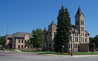
Custer County is a county in the U.S. state of South Dakota. As of the 2020 census, the population was 8,318. Its county seat is Custer. The county was created in 1875, and was organized in 1877. It was named after General George Armstrong Custer.

Bennett County is a county in the U.S. state of South Dakota. As of the 2020 census, the population was 3,381. Its county seat is Martin. Bennett County was removed from the Pine Ridge Reservation by an act of Congress in 1911, much of Bennett County however is still held in trust by the Reservation. To the east is the Rosebud Indian Reservation, where dwell the Sicangu Oyate, also known the Upper Brulé Sioux Nation and the Rosebud Sioux Tribe (RST), a branch of the Lakota people.

Walsh County is a county in the U.S. state of North Dakota. As of the 2020 census, the population was 10,563. Its county seat is Grafton.

Big Stone County is a county in the U.S. state of Minnesota. As of the 2020 census, the population was 5,166. Its county seat is Ortonville.

Valley City is a city in and the county seat of Barnes County, North Dakota, United States. The population was 6,575 at the 2020 census, making it the 12th most populous city in North Dakota. Valley City was founded in 1874.
Wahpeton is a city in Richland County, in southeast North Dakota along the Bois de Sioux River at its confluence with the Otter Tail River, which forms the Red River of the North. Wahpeton is the county seat of Richland County. The population was 8,007 at the 2020 census.
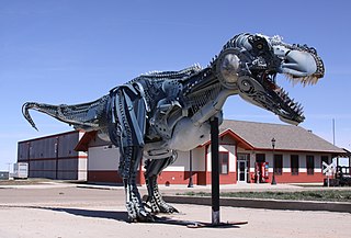
Faith is a city in the northeastern corner of Meade County, South Dakota, United States. The population was 367 at the 2020 census. The most complete Tyrannosaurus rex skeleton known, Sue, was discovered approximately 15 miles (24 km) northeast of Faith in August 1990.

Wounded Knee Creek is a tributary of the White River, approximately 100 miles (160 km) long, in Oglala Lakota County, South Dakota in the United States. Its Lakota name is Čhaŋkpé Ópi Wakpála.
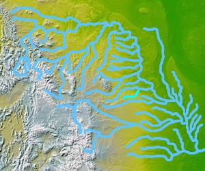
The Little White River is a tributary of the White River, approximately 234 miles (377 km) long, in south central South Dakota in the United States.

Eastview High School is a comprehensive and college preparatory public high school in Apple Valley, Minnesota, United States. Established in 1997, Eastview is the newest of the four high schools serving Independent School District 196. Newsweek ranked the school in their "List of the Top High Schools in America" for the sixth consecutive time. Eastview has also been recognized by U.S. News & World Report as one of America's Best High Schools. In 2013, Eastview was ranked in the top 3% of the most challenging high schools in the United States, as well as a top comprehensive high school in Minnesota. Prior to the 2010–2011 school year, Eastview was a member of the Lake Conference, but then broke off with most of the Lake Conference schools in order to create the South Suburban Conference.
The Ray Mountains is a mountain range in central Alaska named for the Ray River, itself named for United States Army Captain Patrick Henry Ray, who established a meteorological station in Barrow, Alaska, in 1881. The mountains are within the Yukon-Tanana Uplands, an area of low mountain ranges that also includes the White Mountains. The Ray Mountains cover an area of 10,600 square miles (27,454 km2) and are bordered on the east by the Yukon River, on the south by the Tozitna River, and on the north by Kanuti National Wildlife Refuge. The highest point in the Ray Mountains is Mount Tozi, which has a summit elevation of 5,519 feet (1,682 m). Other notable peaks include Wolf Mountain, Mount Henry Eakin, the Kokrines Hills, and Moran Dome.
Lyman High School, located in Presho, South Dakota, is the only high school in Lyman County. It is also the only high school in Lyman School District 42–1, which also includes two elementary schools and a middle school. Lyman High School's athletic teams are nicknamed the "Raiders".
Newton Fork is a stream in the U.S. state of South Dakota.
