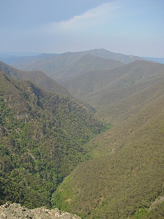
The Kanangra-Boyd National Park is a protected national park that is located in the Central Tablelands region, west of the Southern Highlands and Macarthur regions, in New South Wales, in eastern Australia. The 68,660-hectare (169,700-acre) national park is situated approximately 180 kilometres (110 mi) south-west of Sydney and is contiguous with the Blue Mountains National Park and the Nattai National Park. The park was established in 1969.

Ku-ring-gai Chase National Park is a national park on the northern side of Sydney in New South Wales, Australia. The 14,977-hectare (37,010-acre) park is 25 kilometres (16 mi) north of the Sydney central business district and generally comprises the land east of the M1 Pacific Motorway, south of the Hawkesbury River, west of Pittwater and north of Mona Vale Road. It includes Barrenjoey Headland on the eastern side of Pittwater.

The Oxley Wild Rivers National Park is a protected national park that is located in the Northern Tablelands region of New South Wales, Australia in the Port Macquarie-Hastings City Council and Walcha Shire councils. The 145,223-hectare (358,850-acre) park is situated 445 kilometres (277 mi) north of Sydney and is named in memory of the Australian explorer John Oxley, who passed through the area in 1818 and is one of the largest national parks in New South Wales.

The Royal National Park is a protected national park that is located in Sutherland Shire local government area in the southern portion of Sydney, New South Wales, Australia.

Cania Gorge is a national park in the North Burnett Region, Queensland, Australia, in the locality of Cania.
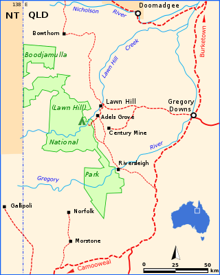
Boodjamulla National Park, formerly known as Lawn Hill National Park, is a national park in the Shire of Burke, Queensland, Australia. The Riversleigh World Heritage Area is a World Heritage Site within the park.

Mount Walsh is a national park in Queensland, Australia, 230 kilometres (140 mi) northwest of Brisbane.

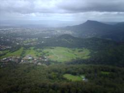
The Springbrook National Park is a protected national park that is located in the Gold Coast hinterland of Queensland, Australia. The 6,197-hectare (15,310-acre) park is situated on the McPherson Range, near Springbrook, approximately 100 kilometres (62 mi) south of Brisbane. The park is part of the Shield Volcano Group of the UNESCO World Heritage–listed Gondwana Rainforests of Australia.

Mount Keira is a suburb and mountain in the Illawarra region of New South Wales, Australia.
Mount Kembla is a suburb and a mountain in the Illawarra region of New South Wales, Australia.
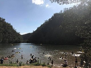
Bents Basin is a protected nature reserve and state park near Wallacia, New South Wales, Australia in the Sydney metropolitan area. The lake basin, which formed at the efflux of the Nepean River from the Hawkesbury Sandstone gorge, is a popular swimming hole with a camping area and an education centre used by local school groups. Also featuring a large woodland area and native wildlife, the reserve is the only picnic area along the Nepean River and it is one of the most popular water-based picnic parks in Greater Western Sydney.

The Illawarra escarpment, or officially the Illawarra Range, is the fold-created cliffs and plateau-eroded outcrop mountain range west of the Illawarra coastal plain south of Sydney, in the state of New South Wales, Australia. The range encloses the Illawarra region which stretches from Stanwell Park in the north to Kiama, Gerringong and the Shoalhaven River in the south.
Chambers Pillar is a sandstone formation some 160 km (100 mi) south of Alice Springs in the Northern Territory of Australia.
The Lerderderg Gorge is in Victoria, Australia and largely within the Lerderderg State Park. The Lerderderg River which emerges from the Great Dividing Range has cut a deep gorge as it winds toward the southern plains. It is suggested that the name Lerderderg is perhaps a corruption of the Wurundjeri word "Larderdark," from 'larh' -stone house and 'dark' -peppermint gum.

The Flinders Peak Group is an unnamed range of hills located on the northern edge of the Scenic Rim Region, south west of Logan City and south east of the City of Ipswich in South East Queensland, Australia. The summit in the Range is Flinders Peak reaching 680 metres (2,230 ft) above sea level.
Rainbow Valley Conservation Reserve is a protected area located south of Alice Springs, Northern Territory in Australia. The reserve was established in 1990 to protect the unique sandstone formations and the Aboriginal art, artifacts and sacred natural objects within an area of 24.83 km2 (9.59 sq mi) around a large sandstone bluff. The sandstone layers in the main formation resemble the coloured stripes of a rainbow, with the red-orange hues of sandstone that is rich with iron creating a strong contrast with the lighter shaded sandstone that turns pale yellow or gold in the late day sun as it shines on the northwest-facing cliffs.
The Yappar River is a river in the Gulf Country region of Far North Queensland, Australia.
The Gregory Range is a mountain range located in Far North Queensland, Australia.

Wetherill Park Nature Reserve, also called Wetherill Park Reserve, is an urban park and a nature reserve situated in the western suburbs of Sydney, New South Wales, Australia. The reserve contains an open woodland and bushland which feature native plants, such as eucalyptus trees, and recreational areas.

White Rock is a locality in the City of Ipswich, Queensland, Australia. In the 2016 census White Rock had a population of 3 people.

