Mouth of Baffle Creek Conservation Park

Last updated

Mouth of Baffle Creek Conservation Parks
Queensland
Australia Queensland relief location map.jpg
Red pog.svg
Mouth of Baffle Creek Conservation Parks
Nearest town or city Bundaberg
Coordinates 24°30′57″S152°03′24″E / 24.51583°S 152.05667°E / -24.51583; 152.05667 Coordinates: 24°30′57″S152°03′24″E / 24.51583°S 152.05667°E / -24.51583; 152.05667
Established1990 [1]
Area3.12 hectares (7.7 acres) [1]
Managing authorities Queensland Parks and Wildlife Service
Website Mouth of Baffle Creek Conservation Parks
See also Protected areas of Queensland

The Mouth of Baffle Creek Conservation Parks are a series of two protected conservation parks located adjacent to the mouth of the Baffle Creek, on the central coastal region of Queensland, Australia.

State park protected area managed at the federated state level

State parks are parks or other protected areas managed at the sub-national level within those nations which use "state" as a political subdivision. State parks are typically established by a state to preserve a location on account of its natural beauty, historic interest, or recreational potential. There are state parks under the administration of the government of each U.S. state, some of the Mexican states, and in Brazil. The term is also used in the Australian state of Victoria. The equivalent term used in Canada, Argentina, South Africa and Belgium, is provincial park. Similar systems of local government maintained parks exist in other countries, but the terminology varies.

In Australia a conservation park is a type of specially protected status for land held by the Crown for conservation purposes. A conservation park may consist of multiple conservation units. As of June 2014, the term ‘Conservation Park’ is used only by the relevant government agencies in Queensland, South Australia and Western Australia.

Central Queensland Region in Queensland, Australia

Central Queensland is an ambiguous geographical division of Queensland that centres on the eastern coast, around the Tropic of Capricorn. Its major regional centre is Rockhampton. The region extends from the Capricorn Coast west to the Central Highlands at Emerald, north to the Mackay Regional Council southern boundary, and south to Gladstone. The region is also known as Capricornia. It is one of Australia's main coal exporting regions.

Contents

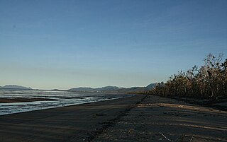
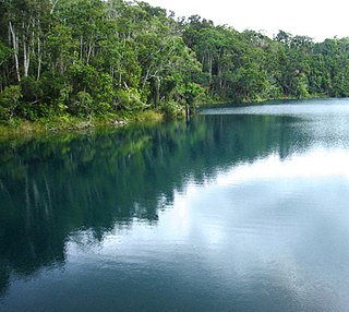
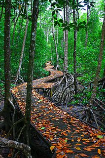
The 312-hectare (770-acre) parks [1] are within the Great Barrier Reef Marine Park coastal region. Baffle Creek is one of Queensland's few remaining undisturbed coastal rivers, and the creek's estuary mouth is protected by Mouth of Baffle Creek Regional Park. This small coastal remnant features sandy beaches backed by low, open, eucalypt and she-oak woodlands with a camping area set behind the fore dunes on the creek's northern shore. There is no camping area on the creek's southern side. [2]

Great Barrier Reef Marine Park Protected area in Queensland, Australia

The Great Barrier Reef Marine Park protects a large part of Australia's Great Barrier Reef from damaging activities. It is a vast multiple-use Marine Park which supports a wide range of uses, including commercial marine tourism, fishing, ports and shipping, recreation, scientific research and Indigenous traditional use. Fishing and the removal of artefacts or wildlife is strictly regulated, and commercial shipping traffic must stick to certain specific defined shipping routes that avoid the most sensitive areas of the park. The Great Barrier Reef is the largest and best known coral reef ecosystem in the world. Its reefs, almost 3000 in total, represent about 10 per cent of all the coral reef areas in the world. It supports an amazing variety of biodiversity, providing a home to thousands of coral and other invertebrate species, bony fish, sharks, rays, marine mammals, marine turtles, sea snakes, as well as algae and other marine plants.

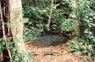
The Mouth of Baffle Creek Conservation Park 1 is a 125-hectare (310-acre) park is located on the creek mouth's southern shore and was first gazetted in 1995 to protect an area of mangrove forest. The Mouth of Baffle Creek Conservation Park 2 is a 187-hectare (460-acre) park protects the creek mouth's northern shore and was first gazetted in 1997, with further land protected in 2010. [1]

Mangrove A shrub or small tree that grows in coastal saline or brackish water

A mangrove is a shrub or small tree that grows in coastal saline or brackish water. The term is also used for tropical coastal vegetation consisting of such species. Mangroves occur worldwide in the tropics and subtropics, mainly between latitudes 25° N and 25° S. The total mangrove forest area of the world in 2000 was 137,800 square kilometres (53,200 sq mi), spanning 118 countries and territories.

See also

Related Research Articles

Protected areas of South Australia areas protected for conservation in the Australian state of South Australia

Protected areas of South Australia consists of protected areas located within South Australia and its immediate onshore waters and which are managed by South Australian Government agencies. As of March 2018, South Australia contains 359 separate protected areas declared under the National Parks and Wildlife Act 1972, the Crown Land Management Act 2009 and the Wilderness Protection Act 1992 which have a total land area of 211,387.48 km2 (81,617.16 sq mi) or 21.5% of the state's area.

Culgoa National Park Protected area in New South Wales, Australia

The Culgoa National Park is a protected national park that is located in the north-west region of New South Wales, in eastern Australia. The 35,239-hectare (87,080-acre) national park is located approximately 660 kilometres (410 mi) northwest of Sydney. The nearest town is Brewarrina, 120 kilometres (75 mi) away. The park's northern boundary is defined by part of the state border between New South Wales and Queensland.

Bowling Green Bay National Park Protected area in Queensland, Australia

Bowling Green Bay is a national park in the City of Townsville and Shire of Burdekin, Queensland, Australia, 1,103 km northwest of Brisbane, and 28 km south of Townsville and 59 km north of Ayr. It is a Ramsar Convention listed site. The park protects diverse range of habitats including the rugged, forested landscape surrounding Mount Elliot and Saddle Mountain as well as coastal estuaries between Cape Cleveland and Cape Bowling Green.

Crater Lakes National Park Protected area in Queensland, Australia

Crater Lakes is a national park in Queensland, Australia, 1367 km northwest of Brisbane. The park contains two volcanically-formed lakes, Lake Barrine and Lake Eacham (Yidyam). Both lakes have walking trails around the lake; boat tours are also given at Lake Barrine.

Culgoa Floodplain National Park Protected area in Queensland, Australia

The Culgoa Floodplain National Park is a protected national park that is located in the South West region of Queensland in eastern Australia. The 42,859-hectare (105,910-acre) national park is situated at the western extent of Hebel in the Shire of Balonne and in the east of Jobs Gate in the Paroo Shire, approximately 630 kilometres (390 mi) west of Brisbane. The park occupies the former pastoral and grazing property of Byra Station. The park's southern boundary is defined by part of the state border between Queensland and New South Wales.

Edmund Kennedy National Park Protected area in Queensland, Australia

Edmund Kennedy is a national park in Queensland, Australia, 1269 km northwest of Brisbane. The national park is part of the Wet Tropics World Heritage Area. It was named after Edmund Kennedy, a mid-nineteenth century explorer.

Great Sandy National Park Protected area in Queensland, Australia

Great Sandy National Park is a coastal national park in the Fraser Coast Region, Queensland, Australia.

Mooloolah River National Park Protected area in Queensland, Australia

The Mooloolah River National Park is a nationally protected area located on the Sunshine Coast, Queensland. It covers an area of 830.9 hectares and is bordered by the Mooloolah River to the east, Claymore and Dixon Roads to the west, and the Lower Mooloolah River Environmental Reserve to the south. It is bisected by the Sunshine Motorway with the northern, 161.93 hectare component of the Park being a later addition. The Park was initially vacant crown land prior to national park designation in 1960. Surrounding land uses include livestock grazing, urban development and the campus of the University of the Sunshine Coast. It is the second largest mainland park on the coastal lowlands in South East Queensland after Noosa National Park and represents an example of low-lying coastal floodplain distinctive of the region.

Russell River National Park Protected area in Queensland, Australia

Russell River is a national park in North Queensland, Australia, 1352 km northwest of Brisbane. The park protects a coastal strip between the sea and the Russell River. It is part of the Coastal Wet Tropics Important Bird Area, identified as such by BirdLife International because of its importance for the conservation of lowland tropical rainforest birds.

Springbrook National Park Protected area in Queensland, Australia

The Springbrook National Park is a protected national park that is located in the Gold Coast hinterland of Queensland, Australia. The 6,197-hectare (15,310-acre) park is situated on the McPherson Range, near Springbrook, approximately 100 kilometres (62 mi) south of Brisbane. The park is part of the Shield Volcano Group of the UNESCO World Heritage–listed Gondwana Rainforests of Australia.

Spicers Gap Road Conservation Park Protected area in Queensland, Australia

The Spicers Gap Road Conservation Park is a protected conservation park located within the Main Range National Park in south east Queensland, Australia. The park is part of the Main Range group World Heritage Site Gondwana Rainforests of Australia inscribed in 1986 and added to the Australian National Heritage List in 2007.

Lake Eacham crater lake

Lake Eacham is a popular lake of volcanic origin on the Atherton Tableland of Queensland, Australia, within the World Heritage listed Wet Tropics of Queensland.

Innes Park, Queensland Town in Queensland, Australia

Innes Park is a coastal town and locality in the Bundaberg Region, Queensland, Australia. The town is 360 kilometres (224 mi) north of the state capital, Brisbane. At the 2016 census, Innes Park had a population of 2302.

Cape Pallarenda Conservation Park Protected area in Queensland, Australia

The Cape Pallarenda Conservation Park is a protected conservation park located 10 kilometres (6.2 mi) north-east of Townsville in the Far North region of Queensland, Australia. The 44-hectare (110-acre) regional park is located within the suburb of Pallarenda.

Coombabah Lake Conservation Park Protected area in Queensland, Australia

The Coombabah Lake Conservation Park is a conservation park that is an Important Wetland in Australia, located in the Gold Coast region of South East Queensland, Australia. Part of the Coomera River catchment, Lake Coombabah is a tidal lake at the mouth of Coombabah Creek. The Coombabah wetlands are significant because they are the most southerly lake and coastal swampland representatives in the bioregion, and because the area provides significant wildlife value and refuge habitat. The conservation area includes tidal marshlands and mangroves along part of the lakes edge. The Melaleuca boardwalk allows viewing of the wildlife. The mangroves are home to frogs, crabs and fish that attract native and migratory birds. There are guided bushwalking and canoeing activities as part of community conservation and environmental workshops to promote local conservation.

Lake Macquarie State Conservation Area is a 761-hectare (1,880-acre) conservation area in New South Wales Australia, approximately 20 kilometres (12 mi) from Newcastle. It is made up of six separate land sections around the coastal saltwater Lake Macquarie, covering 16 kilometres (10 mi) of the lake's foreshore. Though most of the area was declared in 1996 one section, the Morisset area, was added in January 1999.

Ngari Capes Marine Park Protected area in Western Australia

The Ngari Capes Marine Park is a marine protected area on the lower south west coast of Western Australia, located approximately 250 kilometres (160 mi) south of Perth. The 123,790-hectare (305,900-acre) marine park was gazetted on 12 June 2012 and the park's western and southern boundaries are the Limit of Coastal Waters of the State of Western Australia, abutting the South-west Corner Marine Park located within the Australian Commonwealth exclusive economic zone.

Annan River National Park Protected area in Queensland, Australia

Annan River National Park is a national park on Cape York Peninsula in Far North Queensland, Australia. The Annan River from which the park gets its name, marks the northern and western extent of the park. To the east of the park is Walker Bay in the Coral Sea. The park was gazetted in 2006.

Beeron National Park Protected area in Queensland, Australia

Beeron National Park is a national park at Beeron in the Wide Bay–Burnett region of Queensland, Australia. The 7050-hectare park preserves plant species of high conservation value. It was formerly known as Beeron Holding or 'Rocky' paddock.

Kuranda National Park Protected area in Queensland, Australia

Kuranda National Park is a national park in Far North Queensland, Australia. Like many national parks in the area it belongs to the Wet Tropics World Heritage Area. The park protects an important wildlife corridor in which rainforest and open eucalypt forest predominate. Walking, mountain biking and four-wheel driving are popular recreational activities.

References

  1. 1 2 3 4 "Mouth of Baffle Creek Regional Park: Nature, culture and history". Department of National Parks, Recreation, Sport and Racing. Government of Queensland. 9 December 2013. Retrieved 7 September 2014.
  2. "Mouth of Baffle Creek Regional Park". Department of National Parks, Recreation, Sport and Racing. Government of Queensland. 9 December 2013. Retrieved 7 September 2014.