Whitehorse Ranch

Last updated
Whitehorse Ranch
Cattle Ranch
Whitehorse Ranch (Harney County, Oregon scenic images) (harDA0118).jpg
Whitehorse Ranch front gate
USA Oregon location map.svg
Red pog.svg
Whitehorse Ranch
Usa edcp location map.svg
Red pog.svg
Whitehorse Ranch
Coordinates: 42°20′15″N118°14′23″W / 42.33750°N 118.23972°W / 42.33750; -118.23972 Coordinates: 42°20′15″N118°14′23″W / 42.33750°N 118.23972°W / 42.33750; -118.23972
Country Flag of the United States.svg  United States
State Flag of Oregon.svg  Oregon
County Harney and Malheur counties
Established1869
Founded byJohn S. Devine
Area
  Property63,222 acres (25,585 ha)
 
  • The ranch also has BLM grazing allotments covering an additional 287,205 acres (116,228 ha)
Elevation
4,380 ft (1,340 m)
Time zone UTC-8 (Pacific (PST))
OwnerBTAZ Nevada

The Whitehorse Ranch is a historic cattle ranch in Harney and Malheur counties in the southeastern corner of Oregon, United States. The ranch was started in 1869 by John S. Devine, a well-known 19th-century cattle baron. It was originally the headquarters for the Todhunter and Devine Cattle Company. The ranch has been in the cattle business continuously since it was founded. Today, the Whitehorse Ranch includes 63,222 acres (255.85 km2) of deeded property and grazing rights on an additional 287,205 acres (1,162.28 km2) of public range land administered by the Bureau of Land Management.

Contents

History

Native Americans used the area around Whitehorse Creek for thousands of years before the arrival of European settlers. The birds, animals, and plants found in the wetland around the high desert lake provided abundant food for early inhabitants. While there are no records of the earliest people to inhabit the area, by the time Europeans began to explore the area in the early 19th century, the Northern Paiute people were using the area that is now Whitehorse Ranch. [1] [2]

Hudson's Bay Company fur trappers were the first Europeans to visit southeastern Oregon. Peter Skene Ogden passed along the north shore of the Malheur Lakes in 1826. Other fur trapping expeditions followed in the 1830s. Several military expeditions passed through the area in the late 1850s and 1860s. Major Enoch Steen was the first non-native to explore the land that is now southern Harney County. Steens Mountain was named in his honor. In the 1860s, the United States Army established several military outposts east of Steens Mountain including Camp Alvord and Camp C.F. Smith. [3] [4]

John S. Devine was born in Virginia in 1849. He later immigrated to California. In 1868, Devine decided to establish a cattle ranch in southeastern Oregon. To manage the business, he joined W. B. Todhunter to found the Todhunter and Devine Cattle Company. The following summer, Devine and Juan Redon as head Buckaroo with a dozen California vaqueros along with a chuck wagon and a Chinese cook trailed a herd of 2,500 cattle from California to southeastern Oregon while Todhunter stayed behind to look after the company's holding in the San Joaquin Valley. Devine selected a site on Whitehorse Creek southeast of Steens Mountain for his ranch headquarters. [5] [6] [7] [8] The location was near Camp C. F. Smith, which had been established by the United States Army in 1866 (the camp was abandoned in 1869). [4] [8] According to Oregon Geographic Names, a post office was established at this location in 1867 with W. A. Mix as the first postmaster. Mix was among a group of soldiers moving through the area in an effort to relocate Camp Alvord. The post office was called White Horse. The land then was part of Baker County from which Harney County was carved in 1889. [9]

When Devine took up residence at the ranch, he became the first permanent settler in what is now Harney County, Oregon. Devine became a powerful cattle baron, known for his aristocratic manner. He often dressed in the flamboyant Spanish grandee style including silver-studded leather riding gear. He usually rode a white horse as a symbol of the Whitehorse Ranch. Devine enjoyed horse and greyhound racing, breeding some of his race horses at the ranch. He also supplied horses to the Chico–Silver City stage line. Devine built a large stone and timber barn for his horses. The barn was capped by cupola with a white horse weather vane. [6] [7] [10]

Todhunter and Devine cattle grazed widely across the Alvord Basin and into upper Owyhee country until the harsh winter of 1887 killed most of the herd. In 1889, the Whitehorse Ranch was sold to Henry Miller and Charles Lux. At the time, Miller and Lux was the largest cattle operation in the United States. [6] [7]

The Whitehorse Ranch was purchased by Paul Stewart in 1945. He drilled new wells on the property to supplement unreliable surface irrigation. He also expanded wild hay fields and planted alfalfa and corn on ranch property. Los Angeles coin dealer, Roy E. "Ted" Naftzger acquired the ranch in 1961. Naftzger purchased addition land and built the private Whitehorse Ranch Airport at the ranch. [6]

In 1988, the Whitehorse Ranch joined the Bureau of Land Management, United States Fish and Wildlife Service, Oregon Department of Fish and Wildlife, Oregon Environmental Council, Oregon Cattlemen's Association, Oregon Trout, and the Izaak Walton League to found the Trout Creek Mountain Working Group. The group's goal was to review, discuss and resolve land use conflicts in the Trout Creek Mountains area of southeast Oregon. In 1989, the Whitehorse Ranch voluntarily removed its livestock from 50,000 acres (200 km2) of its Whitehorse Butte grazing allotment and two other mountain pastures for a period of three years to prevent over grazing and allow watershed and riparian areas to recover from past grazing. [11] The Trout Creek Mountain Working Group finally agreed on a long-term environmental sustainment plan in 1992. As part of that agreement, the Whitehorse Ranch agreed to reduce the number of its cattle that grazed on public lands from 3,500 to 800. [11] [12]

In 2006, Naftzger sold the ranch to David Herman, a Portland farm equipment dealer and attorney. During the period he owned the ranch, Herman welcomed paying guests who stayed in the ranch's bunkhouse and guest cottages. In 2012, Herman sold the ranch to the BTAZ Nevada cattle company for $10.8 million. Shortly after BTAZ Nevada bought the ranch, the 556,330-acre (2,251.4 km2) Long Draw Fire burned some of the ranch's grazing allotment in the Trout Creek Mountains. [6] [13] [14]

Ranch operation

The Whitehorse Ranch has been continuously operated as a cattle ranch since 1869. Today, it includes 63,222 acres (255.85 km2) of deeded property. The ranch also has Bureau of Land Management grazing allotments that allow its livestock to graze on 287,205 acres (1,162.28 km2) of public range land. When the deeded property and the grazing allotments are combined the ranch stretches 35 miles (56 km) north to south and 27 miles (43 km) east to west. [12] [13]

Whitehorse Ranch meadow with historic barn beyond Whitehorse Ranch (Harney County, Oregon scenic images) (harDA0122).jpg
Whitehorse Ranch meadow with historic barn beyond

The ranch has 135 miles (217 km) of gravel and dirt roads, 135 miles (217 km) of fence, and 12 livestock wells. There are seven irrigation wells with 250 miles (400 km) of irrigation canals and ditches to deliver water to the fields. In addition, the ranch has primary and secondary water rights in several watersheds. The ranch also has one domestic well that provides potable water for ranch houses and other facilities. [13] The ranch has a private air field with two runways. The main runway is 3,247 feet (990 m) long and 94 feet (29 m) wide. [6] [15]

Prior to the Trout Creek Mountain Working Group agreement in 1992, the Whitehorse Ranch kept approximately 3,500 head of cattle on its range lands. Today, the number of cattle has been reduced to 800. The ranch also keeps approximately 50 horses for use on the ranch. The ranch has a small permanent crew; however, additional people are often hired to help with herding, branding, and hay harvesting. The ranch is so large that moving livestock from one pasture to another often takes several days. During these movements, ranch hands herd cattle from dawn to sundown through rugged Oregon High Desert. [13]

The ranch's remote location creates some unique challenges. For example, the ranch uses approximately 10,000 US gallons (38,000 L) of fuel per year. Since there are no local fuel stations, the ranch buys fuel from a wholesale distributor in Eugene and trucks it to the ranch once a year. To conserve fuel, ranch hands use small vehicles to check fences and irrigation ditches. The remoteness of the ranch also requires ranch hands to do most equipment repairs on site. [13]

The Whitehorse Ranch is an official weather station. It reports weather data to NOAA's National Climatic Data Center daily. [16]

Climate data for Whitehorse Ranch, Oregon
MonthJanFebMarAprMayJunJulAugSepOctNovDecYear
Average high °F (°C)41.4
(5.2)
46.8
(8.2)
54.2
(12.3)
61.0
(16.1)
68.8
(20.4)
77.4
(25.2)
87.6
(30.9)
86.5
(30.3)
77.8
(25.4)
65.7
(18.7)
51.0
(10.6)
40.8
(4.9)
63.3
(17.3)
Daily mean °F (°C)31.2
(−0.4)
35.2
(1.8)
41.4
(5.2)
47.1
(8.4)
54.4
(12.4)
61.7
(16.5)
71.0
(21.7)
69.5
(20.8)
60.8
(16.0)
50.5
(10.3)
38.7
(3.7)
30.2
(−1.0)
49.3
(9.6)
Average low °F (°C)20.9
(−6.2)
23.5
(−4.7)
28.6
(−1.9)
33.2
(0.7)
40.0
(4.4)
46.0
(7.8)
54.3
(12.4)
52.5
(11.4)
43.8
(6.6)
35.3
(1.8)
26.5
(−3.1)
19.7
(−6.8)
35.4
(1.9)
Average precipitation inches (mm).63
(16)
.70
(18)
.87
(22)
.92
(23)
.93
(24)
.55
(14)
.21
(5.3)
.68
(17)
.54
(14)
.57
(14)
.67
(17)
.71
(18)
7.98
(202.3)
Source: National Oceanic and Atmospheric Administration, National Climatic Data Center normals data, 1981–2010 [16] [17]

Ranch environment

The native vegetation on the Whitehorse Ranch is dominated by large sagebrush and desert grasses. Other common shrubs include bitterbrush, snowberry, and ceanothus. Patches of mountain mahogany are also found in the area. Common grass species include Idaho fescue, bluebunch wheatgrass, cheatgrass, western needlegrass, Sandberg's bluegrass, Thurber's needlegrass, and bottlebrush squirreltail plus basin wildrye in some well-drained areas. [18]

The ranch supports a wide variety of wildlife including cougar, mule deer, pronghorn antelope, coyote, and jackrabbits. [11] [13] Bird species native to the area include sage grouse, mountain chickadees, gray-headed juncos, black-throated gray warbler, Virginia's warbler, MacGillivray's warbler, pine siskin, red crossbill, bushtit, hermit thrush, and northern goshawks, ravens, and eagles. [19] Creeks on the Whitehorse Ranch are home to Lahontan cutthroat trout. To preserve the riparian ecosystem, the ranch keeps cattle away from creek banks during critical times of the year. [13]

Location

Whitehorse Ranch Road east of Fields, Oregon Whitehorse Ranch Road (Harney County, Oregon scenic images) (harDA0130a).jpg
Whitehorse Ranch Road east of Fields, Oregon

The Whitehorse Ranch is in extremely remote area of southeastern Oregon. It is southeast of Steens Mountain and the Alvord Desert and north of the Trout Creek Mountains. The ranch headquarters is along Whitehorse Creek in the southeast corner of Harney County. However, the ranch also includes property in Malheur County. The base elevation of the ranch is 4,380 feet (1,340 m) above sea level. [13] The elevation at the ranch's air field is 4,447 feet (1,355 m). [15] [20]

The nearest neighbors are ranches 12 miles (19 km) east and west of the Whitehorse Ranch property. The nearest town is the very small unincorporated community of Fields, Oregon, 23 miles (37 km) west of the ranch headquarters. The equally small community of Denio, Nevada, is 42 miles (68 km) southwest of the ranch. Burns, Oregon, the county seat of Harney County, is 130 miles (210 km) to the north and west of the ranch. Caldwell, Idaho is 165 miles (266 km) away. [13] [20]

The ranch is located on Whitehorse Ranch Road, a gravel road that extends 50 miles (80 km) from Oregon Route 205 8 miles (13 km) south of Fields to U.S. Route 95 between Jordan Valley, Oregon, and McDermitt, Nevada. [13] [20]

Related Research Articles

<span class="mw-page-title-main">Harney County, Oregon</span> County in Oregon, United States

Harney County is one of the 36 counties in the U.S. state of Oregon. As of the 2020 census, the population was 7,495, making it the sixth-least populous county in Oregon. The county seat is Burns. Established in 1889, the county is named in honor of William S. Harney, a military officer of the period, who was involved in the Pig War and popular in the Pacific Northwest.

<span class="mw-page-title-main">Harney Basin</span> Endorheic basin in Oregon, United States

The Harney Basin is an endorheic basin in southeastern Oregon in the United States at the northwestern corner of the Great Basin. One of the least populated areas of the contiguous United States, it is located largely in northern Harney County, bounded on the north and east by the Columbia Plateau—within which it is contained, physiographically speaking—and on the south and west by a volcanic plain. The basin encompasses an area of 1,490 square miles (3,859 km2) in the watershed of Malheur Lake and Harney Lake. Malheur Lake is a freshwater lake, while Harney Lake is saline-alkaline.

<span class="mw-page-title-main">Steens Mountain</span> Mountain in Oregon, United States

Steens Mountain is in the southeastern part of the U.S. state of Oregon, and is a large fault-block mountain. Located in Harney County, it stretches some 50 miles (80 km) north to south, and rises from the west side the Alvord Desert at elevation of about 4,200 feet (1,300 m) to a summit elevation of 9,738 feet (2,968 m). Steens Mountain is not part of a mountain range but is properly a single mountain, the largest of Oregon's fault-block mountains.

<span class="mw-page-title-main">Malheur National Wildlife Refuge</span>

Malheur National Wildlife Refuge is a National Wildlife Refuge located roughly 30 miles (48 km) south of the city of Burns in Oregon's Harney Basin. Administered by the United States Fish and Wildlife Service, the refuge area is roughly T-shaped with the southernmost base at Frenchglen, the northeast section at Malheur Lake and the northwest section at Harney Lake.

<span class="mw-page-title-main">Donner und Blitzen River</span> River in Oregon, United States

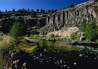
The Donner und Blitzen River is a river on the eastern Oregon high desert that drains a relatively arid basin, the southern portion of Harney Basin, from roughly 20 to 80 miles south-southeast of Burns including Malheur National Wildlife Refuge. Though much of its course is marsh, it offers scenic glaciated canyons, unique ecosystems, and exceptional wild trout fisheries. Named by soldiers of German origin, the Donner und Blitzen River translates as "thunder and lightning". The name usually brings to mind two of Santa Claus's reindeer, but the river is named for a thunderstorm the soldiers experienced as they crossed the river; dry lightning is an almost daily occurrence in the region during certain times of the year.

<span class="mw-page-title-main">Malheur Lake</span> Body of water

Malheur Lake is one of the lakes in the Malheur National Wildlife Refuge in Harney County in the U.S. state of Oregon. Located about 18 miles (29 km) southeast of Burns, the lake is marsh fed by the Donner und Blitzen River from the south and the Silvies River from the north. Malheur Lake periodically overflows into Mud Lake to the west and thence to Harney Lake, the sink of Harney Basin.

<span class="mw-page-title-main">Harney Lake</span> Alkali lake basin in Oregon, US

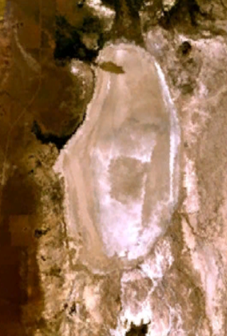
Harney Lake is a shallow alkali lake basin located in southeast Oregon, United States, approximately 30 miles (48 km) south of the city of Burns. The lake lies within the boundary of the Malheur National Wildlife Refuge and is the lowest point in the Blitzen Valley drainage.

<span class="mw-page-title-main">Malheur Indian Reservation</span>

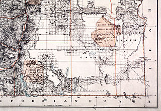
The Malheur Indian Reservation was an American Indian reservation established for the Northern Paiute in eastern Oregon and northern Nevada from 1872 to 1879. The federal government discontinued the reservation after the Bannock War of 1878, under pressure from European-American settlers who wanted the land. This negative recommendation against continuing by its agent William V. Rinehart, led to the internment of more than 500 Paiute on the Yakama Indian Reservation, as well as the reluctance of the Bannock and Paiute to return to the lands after the war.

<span class="mw-page-title-main">Alvord Lake (Oregon)</span> Body of water

Alvord Lake is a seasonal shallow alkali lake in Harney County of the U.S. state of Oregon. Its elevation is 4,026 feet (1,227 m). It is located about 10 miles (16 km) southeast of Alvord Desert in the Alvord Basin and serves as terminus for all its streams. Its water level varies from dry to several feet deep. The nearest habitation is tiny Fields, 14.1 kilometres (8.8 mi) SSW.

<span class="mw-page-title-main">Fields, Oregon</span> Unincorporated community in the state of Oregon, United States

Fields is an unincorporated community in Harney County, Oregon, United States, located 112 miles (180 km) south of Burns. It is the center of commerce for local ranches and the largest community between Denio, Nevada, 22 miles (35 km) to the south, and Frenchglen, Oregon, 52.4 miles (84.3 km) to the north.

<span class="mw-page-title-main">Diamond, Oregon</span> Unincorporated community in the state of Oregon, United States

Diamond is an unincorporated community in Harney County, Oregon, United States. Diamond is west of Oregon Route 205 and south of Malheur Lake, 52 miles (84 km) south-southeast of Burns by highway. Its post office is assigned ZIP code 97722.

<span class="mw-page-title-main">Pueblo Mountains</span> Mountain range in southeastern Oregon and northwestern Nevada, United States

The Pueblo Mountains are a remote mountain range in the United States located mostly in southeastern Oregon and partially in northwestern Nevada. The highest point in the range is Pueblo Mountain. The dominant vegetation throughout is grasses and big sagebrush; however, there are meadows with cottonwood, aspen, and willow groves along some stream drainages. Most of the range is public land administered by the Bureau of Land Management. There is very little human development in the Pueblo Mountains, and most visitors come for backpacking cross-country, camping, and hunting.

<span class="mw-page-title-main">Trout Creek Mountains</span> Mountain in United States of America

The Trout Creek Mountains are a remote, semi-arid Great Basin mountain range mostly in southeastern Oregon and partially in northern Nevada in the United States. The range's highest point is Orevada View Benchmark, 8,506 feet (2,593 m) above sea level, in Nevada. Disaster Peak, elevation 7,781 feet (2,372 m), is another prominent summit in the Nevada portion of the mountains.

<span class="mw-page-title-main">P Ranch</span> United States historic place

The P Ranch is a historic ranch in Harney County in southeastern Oregon, United States. The remaining ranch structures are located on the west bank of the Donner und Blitzen River in the Malheur National Wildlife Refuge. The ranch was built by Peter French, a well known 19th-century cattle baron. The P Ranch became headquarters for the French-Glenn Livestock Company, which eventually covered over 140,000 acres (570 km2). After French was murdered in 1897, the French-Glenn Livestock Company slowly sold off the P Ranch property. In 1935, the United States Government purchased the remaining P Ranch property to add to an adjacent wildlife refuge. The Civilian Conservation Corps demolished most of the original ranch buildings in the 1930s, and a fire destroyed the main ranch house in 1947. The few remaining P Ranch structures are now listed on the National Register of Historic Places.

<span class="mw-page-title-main">Sod House Ranch</span> United States historic place

The Sod House Ranch is a historic ranch in Harney County in southeastern Oregon, United States. The remaining ranch structures are located south of Malheur Lake in the Malheur National Wildlife Refuge. The ranch was built by Peter French, a well known 19th-century cattle baron. The Sod House Ranch became the headquarters for the northern operating division of the French-Glenn Livestock Company, which eventually covered over 140,000 acres (570 km2). After French was murdered in 1897, the French-Glenn Livestock Company slowly sold off its ranch property. In 1935, the United States Government purchased the Sod House Ranch property to add to an adjacent wildlife refuge. The eight remaining Sod House Ranch buildings are now listed on the National Register of Historic Places.

<span class="mw-page-title-main">Bill Hanley (rancher)</span>

William D. Hanley, known as Bill Hanley, was a pioneer rancher in Harney County in southeastern Oregon. He owned several ranches between Burns, Oregon and Harney Lake. Together, his properties comprised one of the largest privately owned cattle operations in the United States. Hanley was also a progressive thinker and well known host. Among his personal friends were leading political figures, fellow cattle barons, industrialist, writers, and artists including Theodore Roosevelt, William Howard Taft, William Jennings Bryan, Peter French, James J. Hill, CES Wood, and Will Rogers. Hanley's progressive political views led him to run for Governor of Oregon and the United States Senate. A strong advocate of wildlife conservation, much of his ranch is now part of the Malheur National Wildlife Refuge.

<span class="mw-page-title-main">Double-O Ranch Historic District</span> Historic district in Oregon, United States

The Double-O Ranch Historic District is located west of Harney Lake in Harney County in southeastern Oregon, United States. At one time, the Double-O Ranch covered over 17,000 acres (69 km2). The ranch was owned by Bill Hanley, a well-known cattle baron and Bull Moose progressive. In 1941, the United States Government purchased most of the Double O Ranch property and added it to the Malheur National Wildlife Refuge. The two remaining Double-O Ranch buildings are now listed on the National Register of Historic Places.

<span class="mw-page-title-main">Kiger Creek (Harney County, Oregon)</span> River in Oregon, United States

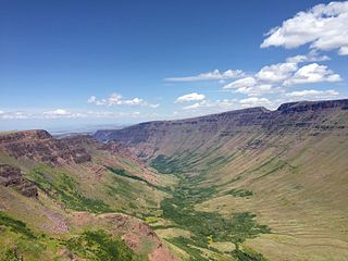
Kiger Creek is a tributary of Swamp Creek in Harney County in the U.S. state of Oregon. It originates on Steens Mountain and flows generally north through Kiger Gorge to meet Swamp Creek near the unincorporated community of Diamond. The combined streams flow into Diamond Swamp and the Malheur National Wildlife Refuge.

<span class="mw-page-title-main">Catlow Valley</span>

The Catlow Valley is a basin in Harney County, Oregon, United States. It is a remote valley at the northwestern corner of North America's Basin and Range Province. The valley is named after a pioneer rancher, John Catlow. The area was used by Native Americans for thousands of years before European explorers arrived in the 19th century. Today, cattle ranching is the main commercial activity in the valley. The public land in the Catlow Valley is administered by the Bureau of Land Management. This public land offers a number of recreational opportunities including hiking, hunting, fishing, bird watching, and wildlife viewing.

<span class="mw-page-title-main">High Desert Discovery Scenic Byway</span>

The High Desert Discovery Scenic Byway is a 127-mile-long (204 km) scenic highway in the southeastern part of the U.S. state of Oregon. It runs through the state's high desert country from the town of Burns to the unincorporated community of Fields. It was designated as an Oregon Scenic Byway in 2003. The highway is maintained by the Oregon Department of Transportation (ODOT). There are a number of points of interest along the route including several that are listed on the National Register of Historic Places.

References

  1. "The Prehistory of the Malheur Marshes", Malheur National Wildlife Refuge, United States Fish and Wildlife Service, United States Department of Interior, Princeton, Oregon, 10 November 2008.
  2. Jackman, E. R. and John Scharff, "The Indians", Steens Mountain in Oregon's High Desert Country, Caxton Printers, Caldwell, Idaho, 1967, pp. 33–35.
  3. "A Little Bit of Malheur History" Archived 2014-09-27 at the Wayback Machine , Malheur National Wildlife Refuge, United States Fish and Wildlife Service, United States Department of Interior, Princeton, Oregon, 10 November 2008.
  4. 1 2 McArthur, Lewis A. and McArthur, Lewis L., "Camp C. F. Smith," Oregon Geographic Names (Seventh Edition), Oregon Historical Society Press; Portland, Oregon, December 2003, p. 143.
  5. McArthur, Lewis A. and McArthur, Lewis L., "Whitehorse Ranch", Oregon Geographic Names (Seventh Edition), Oregon Historical Society Press; Portland, Oregon, December 2003, pp. 1032–1033.
  6. 1 2 3 4 5 6 Wheat, Dan, "Ranch Founded on Site of Cavalry Post", Capital Press Agriculture Weekly, Salem, Oregon, 7 June 2012.
  7. 1 2 3 LaLande, Jeff, "Settling Up the Country: Founding a Cattle Kingdom, 1870s-1880s", The Oregon History Project, Oregon Historical Society, Portland, Oregon, 2005.
  8. 1 2 Boyd, Bob, "Buckaroos", The Oregon Encyclopedia , Portland State University, 2013.
  9. McArthur, Lewis A.; McArthur, Lewis L. (2003) [1928]. Oregon Geographic Names (7th ed.). Portland, Oregon: Oregon Historical Society Press. p. 1030. ISBN   978-0875952772.
  10. Jackman, E. R. and John Scharff, "Harney County", Steens Mountain in Oregon's High Desert Country, Caxton Printers, Caldwell, Idaho, 1967, p. 2.
  11. 1 2 3 "About the Trout Creek Mountain Working Group", The Aurora Project, Bureau of Land Management, United States Department of Interior, Prineville, Oregon, 15 April 2000.
  12. 1 2 Wheat, Dan, "Healing Rangeland Leaves Grazing Scars", Capital Press Agriculture Weekly, Salem, Oregon, 28 June 2012.
  13. 1 2 3 4 5 6 7 8 9 10 Wheat, Dan, "'Rawhide Country' thrives on cattle, history", Capital Press Agriculture Weekly, Salem, Oregon, 8 June 2012.
  14. Wheat, Dan, "Wildfires threaten ranches' future", Capital Press Agriculture Weekly, Salem, Oregon, 11 October 2012.
  15. 1 2 "Whitehorse Ranch", National Flight Data Center, Federal Aviation Administration, Washington, D.C., 7 April 2013.
  16. 1 2 "1981-2010 Normals Data Access", National Oceanic and Atmospheric Administration, National Climatic Data Center, Asheville, North Carolina, 7 April 2013.
  17. "Whitehorse Ranch, Oregon, USA", Climate, Global Warming, and Daylight Charts and Data (data from National Oceanic and Atmospheric Administration United States Daily Climate Normals 1971-2000; Station OR359290), www.climate-charts.com, 2010.
  18. "Description of Existing Environment" (PDF), Trout Creek Geographic Management Area – Standards of Rangeland Health Evaluation, Vale District, Bureau of Land Management, United States Department of Interior, Vale, Oregon, August 2006.
  19. "Oregon Canyon and Trout Creek Mountain Woodlands", Audubon Society of Portland, Portland, Oregon, 23 April 2009.
  20. 1 2 3 "Whitehorse Ranch", Oregon topographic map, United States Geological Survey, United States Department of Interior, Reston, Virginia; displayed via ACME mapper, www.acme.com, 8 August 2010.