Clarion Municipal Airport is a city-owned public-use airport located one nautical mile (1.85 km) northwest of the central business district of Clarion, a city in Wright County, Iowa, United States. This airport is included in the FAA's National Plan of Integrated Airport Systems for 2009–2013, which categorized it as a general aviation facility.

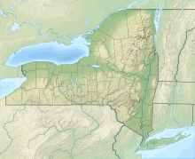
Lt. Warren Eaton Airport, also known as Lt. Warren E. Eaton Airport, is a county-owned public-use airport in Chenango County, New York, United States. It is located two nautical miles (4 km) north of the central business district of Norwich, New York. It was established on June 17, 1952.

Mesquite Airport is a public use airport located two nautical miles (4 km) north of the central business district of Mesquite, in Clark County, Nevada, United States. It is owned by the City of Mesquite.

Enterprise Municipal Airport is a city-owned, public-use airport located three nautical miles (6 km) west of the central business district of Enterprise, a city in Coffee County, Alabama, United States. It is included in the National Plan of Integrated Airport Systems for 2011–2015, which categorized it as a general aviation facility.
Potsdam Municipal Airport, also known as Damon Field, is a village owned, public use airport located two nautical miles (4 km) east of Potsdam, a village in the Town of Potsdam, St. Lawrence County, New York, United States. It is included in the National Plan of Integrated Airport Systems for 2019–2023, which categorized it as a general aviation facility.
Gansner Field is a public use airport owned by and located in Plumas County, California, United States. The airport is one nautical mile (2 km) north of the center of Quincy, California. It is included in the National Plan of Integrated Airport Systems for 2011–2015, which categorized it as a general aviation facility.

Gold Beach Municipal Airport is a public use airport located in Gold Beach, a city in Curry County, Oregon, United States. It is owned by the Port of Gold Beach. This airport is included in the National Plan of Integrated Airport Systems for 2011–2015, which categorized it as a general aviation facility.

Sylacauga Municipal Airport, also known as Merkel Field, is a city-owned public-use airport located three nautical miles west of the central business district of Sylacauga, a city in Talladega County, Alabama, United States. It is included in the FAA's National Plan of Integrated Airport Systems for 2011–2015, which categorized it as a general aviation facility.

Weedon Field is a city-owned, public-use airport located three nautical miles north of the central business district of Eufaula, a city in Barbour County, Alabama, United States.
Parlin Field is a public use airport in Sullivan County, New Hampshire, United States. It is owned by the Town of Newport and located two nautical miles north of its central business district. It is included in the Federal Aviation Administration (FAA) National Plan of Integrated Airport Systems for 2017–2021, in which it is categorized as a local general aviation facility.

Canandaigua Airport is a public-use airport in Ontario County, New York, United States. It is owned by the Ontario County IDA and is located three nautical mile (5.56 km) northwest of the central business district of the City of Canandaigua. According to the FAA's National Plan of Integrated Airport Systems for 2007-2011, it is categorized as a reliever airport.
Randall Airport is a public use airport in Orange County, New York, United States. It is owned by Aerodrome Dev Corp and is located two nautical miles (3.74 km) southeast of the central business district of the City of Middletown. According to the FAA's National Plan of Integrated Airport Systems for 2007–2011, it is categorized as a reliever airport.
Williamson–Sodus Airport is a privately owned, public use airport in Wayne County, New York, United States. It is located three nautical miles (6 km) west of the central business district of Sodus, and east of Williamson. This airport is included in the National Plan of Integrated Airport Systems for 2011–2015, which categorized it as a reliever airport.
Independence Municipal Airport is a city-owned public-use airport located three nautical miles (6 km) southwest of the central business district of Independence, a city in Buchanan County, Iowa, United States. As per the FAA's National Plan of Integrated Airport Systems for 2009-2013, it is classified as a general aviation airport.
Morrilton Municipal Airport is a public use airport located two nautical miles southeast of the central business district of Morrilton, in Conway County, Arkansas, United States. It is owned by the City of Morrilton.
New Castle-Henry County Municipal Airport is a public use airport located four nautical miles southeast of the central business district of New Castle, a city in Henry County, Indiana, United States. It is included in the National Plan of Integrated Airport Systems for 2011–2015, which categorized it as a general aviation facility.
James G. Whiting Memorial Field is a city-owned public-use airport located one nautical mile (2 km) north of the central business district of Mapleton, a city in Monona County, Iowa, United States. It is included in the National Plan of Integrated Airport Systems for 2011–2015, which categorized it as a general aviation facility.
Boone Municipal Airport is a city-owned public-use airport located two nautical miles (4 km) southeast of the central business district of Boone, a city in Boone County, Iowa, United States. It is included in the National Plan of Integrated Airport Systems for 2011–2015, which categorized it as a general aviation facility.
Creston Municipal Airport is a city-owned public-use airport located three nautical miles (6 km) south of the central business district of Creston, a city in Union County, Iowa, United States. It is included in the National Plan of Integrated Airport Systems for 2011–2015, which categorized it as a general aviation facility.
Kentland Municipal Airport is a public use airport located one nautical mile (2 km) southeast of the central business district of Kentland, in Newton County, Indiana, United States. It is owned by the Kentland Board of Aviation Commissioners. This airport was included in the National Plan of Integrated Airport Systems for 2011–2015, which categorized it as a general aviation facility.