
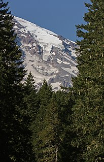
Emmons Glacier is on the northeast flank of Mount Rainier, in Washington. At 4.3 sq mi (11 km2), it has the largest surface area of any glacier in the contiguous United States. The glacier was named after the geologist Samuel Franklin Emmons after his involvement in a survey of Mount Rainier in 1870.

Boulder Glacier is located on the southeast slope of Mount Baker, a stratovolcano near the Pacific coast of North America in the Cascade Range of Washington. Boulder Glacier is the sixth largest on Mount Baker with an area of 1.3 square miles (3.4 km2). It flows from the summit crater between Grant Peak and Sherman Peak to about 5,000 ft (1,500 m). It is noteworthy for retreating 1,610 ft (490 m) between 1987 and 2008, leaving newly exposed rock and soil behind.

The Nisqually Glacier is one of the larger glaciers on the southwestern face of Mount Rainier in the U.S. state of Washington. The glacier is one of the most easily viewed on the mountain, and is accessible from the Paradise visitor facilities in Mount Rainier National Park. The glacier has had periods of advance and retreat since 1850 when it was much more extensive. It is currently retreating. Measurements made at 9,200 feet (2,800 m) altitude show that glacier got 56 ft (17 m) thicker between 1994 and 1997, suggesting that it will probably begin advancing in the first decade of the 21st century. Nisqually Glacier is the source of the Nisqually River.

The Inter Glacier or Interglacier, is a small glacier on the northeast face of Mount Rainier in Washington. The body of ice has a volume of 0.6 billion feet3 and covers an area of 0.3 mile2 (0.8 km2). The glacier lies on top of a wedge called the Steamboat Prow in between the Emmons Glacier to the south and the Winthrop Glacier to the north. The glacier starts below the Steamboat Prow at about 9,400 feet (2,900 m) and flows northeast down to its moraine at 7,000 feet (2,100 m). The gentle topography under the glacier results in a smooth glacial surface with little in the way of crevasses. A small subsidiary peak of Rainier, named Mount Ruth, lies adjacent to the glacier. Meltwater from the glacier drains into the White River.

Fryingpan Glacier is on the eastern face of the 11,138-foot (3,395 m) Little Tahoma Peak, just to the east of Mount Rainier in the U.S. state of Washington. The glacier is located on top of a cliff from the Emmons Glacier to the north and a small ridge separates this glacier from the Whitman Glacier to the south, except for a small snowfield in which these two glaciers are connected. Most of the ice is located on a broad plateau at an elevation of 8,000 to 8,600 feet. The head of the Fryingpan Glacier is located to the northeast of the ridge and at the foothill of Little Tahoma Peak at around 9,100 to 9,800 feet. The glacier flows downhill eastward and the uneven topography causes the glacier surface to be crevassed The glacier ends on shallow to steep slopes at about 7,100 to 7,500 feet. Numerous snowfields and alpine meadows are located near the bottom and east of the glacier. Meltwater from the glacier drains into the White River.
The Van Trump Glacier is actually a scattering of glaciers and snowfields located on the southern flank of Mount Rainier in Washington. Named after P. B. Van Trump, who was part of an early ascent of Mount Rainier, the glacier covers 0.2 square miles (0.5 km2) and contains 500 million ft3 of ice. The glacier is located between the Wilson Glacier to the east and the Kautz Glacier to the west. The elevation of the scattering ranges from 7,000 feet (2,100 m) at the lower end to 9,800 ft (3,000 m) on the upper reaches of the glacier. Meltwater from the glacier drains into the Nisqually River.
The Pyramid Glacier is actually a scattering of glaciers and snowfields located on the south-southwestern flank of Mount Rainier in Washington. It covers 0.2 square miles (0.5 km2) and contains 400 million ft3 of ice. The glaciers lie at an elevation ranging from about 7,000 feet (2,100 m) to 9,000 ft (2,700 m). The Success Divide separates this glacier from the South Tahoma Glacier to the west. Both the Success Glacier and lower end of the Kautz Glacier border this glacier on the eastern side. Meltwater from the glacier drains into the Nisqually River.

Ingraham Glacier is on the south-eastern flank of Mount Rainier, in the U.S. state of Washington. The glacier is named for the Mount Rainier enthusiast Edward Sturgis Ingraham. From the summit ice cap, Ingraham Glacier flows east between Gibraltar Rock,, and Disappointment Cleaver and south of Little Tahoma Peak, which divides it from the much larger Emmons Glacier to the north. Descending southeast, it approaches the east flank of Cowlitz Glacier and the two glaciers nearly join at 6,700 ft (2,000 m). Meltwater from the glacier drains into the Cowlitz River.

The Russell Glacier is a medium-sized glacier on the north flank of Mount Rainier, Washington. Named for the geologist Israel Russell, it covers 1.3 square miles (3.4 km2) and contains 3.1 billion ft3 of ice. Starting from its highest point at 9,400 feet (2,900 m), the Russell Glacier flows northeast towards the Carbon Glacier and contributes ice to the larger glacier before becoming distinct below 7,000 feet (2,100 m). With most of the ice located from 8,000 feet (2,400 m) to 9,000 feet (2,700 m), the glacier only descends to 6,800 feet (2,100 m), unlike the much lower extent of the Carbon Glacier. Echo Rock and 8,364 ft (2,549 m) Observation Rock, two minor sub-peaks of Rainier, lie northwest of this glacier. Meltwater from the glacier eventually reaches the Carbon River.
The Success Glacier is a small glacier located on the southwestern slopes of Mount Rainier in Washington. It covers 0.3 square miles (0.8 km2) and contains 500 million cubic ft of ice. The glacier is bounded to the northwest by the Success Cleaver and to the east by the Kautz Cleaver. Starting from a steep rocky slope at about 11,000 feet (3,400 m), the glacier flows southward downhill. At around 9,000 feet (2,700 m), a small snowfield joins this glacier with the Pyramid Glacier to the southwest. Soon after this point, the glacier joins the adjacent Kautz Glacier at 8,600 feet (2,600 m). The joined glaciers flow until their terminus at about 6,000 ft (1,800 m). Meltwater from the glacier drains into the Nisqually River.
The Kautz Glacier is a narrow glacier on the southern flank of Mount Rainier in Washington. Named for August Kautz, who is sometimes credited for the first ascent of Mount Rainier, covers 1.8 square miles (4.7 km2) and contains 7.8 billion ft3 of ice. Upper Kautz Glacier extends south from the summit ice cap to Kautz Ice Cliff at about 11,700 feet (3,600 m). Immediately west of the main ice cliff, the glacier continues down Kautz Chute which terminates in another ice cliff just above the lower Kautz Glacier at 10,800 feet (3,300 m). Usually reached by a short descent from Camp Hazard at 11,300 feet (3,400 m) on Wapowety Cleaver, climbers following the Kautz Glacier climbing route ascend this chute to the upper glacier.

The Wilson Glacier is a medium-sized tributary glacier located on the southeast flank of Mount Rainier in Washington. Named after A.D. Wilson, who was part of an early ascent of Mount Rainier, the body of ice has an area of 0.5 square miles (1.3 km2) and has a volume of 1.9 billion feet3. The glacier is directly feeds ice to the adjacent, but much larger Nisqually Glacier. Starting from the head at 9,700 feet (3,000 m), the glacier flows downhill southward. One part of the glacier meets the Nisqually Glacier at 8,000 feet (2,400 m) and the other part of the glacier ends on a cliff in between the Wilson and Nisqually Glacier at 7,200 ft (2,200 m). Meltwater from the glacier feeds the Nisqually River.

Paradise Glacier is a glacier on the southeast flank of Mount Rainier in Washington. It covers 0.4 square miles (1.0 km2) and contains 0.8 billion ft3 with Stevens Glacier included. The glacier is bounded to the west by the Muir Snowfield, Anvil Rock and McClure Rock. There is a single extant main lobe of the glacier, ranging from 9,000 feet (2,700 m) to 7,200 feet (2,200 m), that is connected to the larger Cowlitz Glacier. To the south, there was a smaller portion which was near the Cowlitz Rocks and the tiny Williwakas Glacier, ranging from 6,900 feet (2,100 m) to 6,400 ft (2,000 m) in elevation and containing the Paradise Ice Caves until the 1990s. This smaller lobe melted between 2004 and 2006. Meltwater from the glacier drains into the Cowlitz River.

The Ohanapecosh Glacier is small glacier located on Mount Rainier's southeastern flanks in Washington. It covers 0.6 square miles (1.6 km2) and contains 1.3 billion ft3 of ice. The glacier consists of several lobes of ice interconnected by thin snowfields. Most of the glacier lies at an elevation of 8,300 feet (2,500 m) to 7,400 feet (2,300 m), near the Whitman and the Fryingpan Glacier. Since this ice lobe ends on a cliff, it contributes ice to the lower portions of the Ohanapecosh Glacier. The lower sections of this glacier end on cliffs and a small valley at about 6,100 ft (1,900 m) in elevation. Meltwater from the glacier drains into the Ohanapecosh River and the Muddy Fork Cowlitz River, which merge downstream about four miles (6 km) outside of Mount Rainier National Park into the Cowlitz River.
The South Mowich Glacier is a glacier located on the western flank of Mount Rainier in Washington. It covers 1.4 square miles (3.6 km2) and contains 4.5 billion ft3 of ice. Starting from the high-altitude cliffs above the Sunset Amphitheater at over 12,000 feet (3,700 m), the glacier flows west down Mount Rainier. The glacier is connected to the large Tahoma Glacier to the south near St. Andrews Rock at 11,000 feet (3,400 m). After leaving the Amphitheater, there is an icefall on the glacier where it plunges down below 10,000 feet (3,000 m). As the glacier descends, it gradually turns and by the time the South Mowich meets the Puyallup Glacier at 8,800 feet (2,700 m), the glacier is flowing northwest. As the glacier nears Jeanette Heights, it passes by several turns and becomes very rocky in comparison to the upper sections of the glacier. The glacier splits into two arms before their termini, with a shorter, northern arm ending at 5,500 feet (1,700 m) and the longer, larger southern arm ending near a stand of conifers at 5,100 ft (1,600 m). Meltwater from the glacier drains into the South Mowich River which eventually merges with the Puyallup River.

The Tahoma Glacier is a long glacier mostly on the western flank of Mount Rainier in Washington. It covers 1.2 square miles (3.1 km2) and contains 4.3 billion cubic feet of ice. The glacier starts out near the summit of the volcano at over 14,200 feet (4,300 m). As the glacier flows west-southwest out of the summit area, it cascades down a steep rocky face as an icefall from 13,200 feet (4,000 m) to 11,000 feet (3,400 m), where the glacier is connected to the South Mowich Glacier to the north in the Sunset Amphitheater. As the glacier drops below 10,000 feet (3,000 m), it broadens and joins the smaller South Tahoma Glacier. After the broad expanse of ice at over 8,000 feet (2,400 m), the Tahoma Glacier narrows as it descends around the rocky 7,690-foot (2,344 m) Glacier Island, a sub-peak of Rainier once fully encircled by both the South Tahoma and Tahoma Glaciers. Leaving the bottleneck in the glacier, the glacier splits; the larger, longer northern arm continues flowing west-southwest and terminates at around 5,500 feet (1,700 m). The southern arm flows south towards the arm of the South Tahoma Glacier, but this arm terminates before it rejoins the South Tahoma at 5,700 ft (1,700 m). Meltwater from the glacier is the source of the South Puyallup River and Tahoma Creek, a tributary of the Nisqually River.
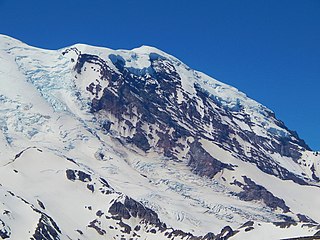
The Winthrop Glacier is a large glacier on the northeastern side of Mount Rainier in Washington. Named after Theodore Winthrop, the body of ice covers 3.5 mile2 (9.1 km2) and has a volume of 18.5 billion feet3. Starting at over 14,300 feet (4,400 m) at the Columbia Crest, the glacier heads north and descends steeply over the uneven topography of Rainier. Another glacier, the Emmons Glacier is directly connected to this glacier up to the Steamboat Prow. After passing the Prow, the glaciers split up; the Emmons heads east-northeastward and the Winthrop continues northeast. As the terrain becomes flatter, the Winthrop glacier becomes heavily rock-covered when it terminates in a forest at about 4,900 ft (1,500 m). Meltwater from the glacier drains into the White River.

The North Mowich Glacier is a glacier located on the northwest flank of Mount Rainier in Washington. It covers 2.4 square miles (6.2 km2) and contains 9.5 billion ft3 of ice. Starting from the foot of Rainier's steep Mowich Face at about 9,600 feet (2,900 m), the glacier first consists of two lobes of ice that flow downhill to the northwest. The southern arm of the glacier is connected to the adjacent Edmunds Glacier. As the two sections of ice join up, they form a large, relatively flat plateau of ice ranging from 7,800 feet (2,400 m) to 8,300 feet (2,500 m). This plateau is an unbroken expanse of ice except for Needle Rock, which pokes out of the glacier ice. From then on, the southern part of the glacier terminates at about 6,400 feet (2,000 m), while the northern, rocky arm flows down a glacial valley and ends at about 5,800 ft (1,800 m) in elevation. The North Mowich Glacier gives rise to the North Mowich River.

The Puyallup Glacier is a glacier on the west flank of Mount Rainier in Washington. It covers 2.0 square miles (5.2 km2) and contains 10.2 billion ft3 of ice. Sharing the same source of ice as the northern South Mowich Glacier, the Puyallup Glacier begins as a branch off the ice stream that flow out of the Sunset Amphitheater. From the split at around 8,500 feet (2,600 m), the glacier expands into a broad sheet of ice ranging from 8,400 feet (2,600 m) to 7,400 feet (2,300 m) in elevation. Leaving the large expanse of ice, the glacier flows down a small valley, it narrows significantly as it turns northwestward. From there on, the glacier is dirty and ends on steep, uneven terrain at about 6,000 ft (1,800 m). The glacier gives rise to the Puyallup River.
The South Tahoma Glacier is a glacier located on the southwest flank of Mount Rainier in State of Washington. It covers 1.1 square miles (2.8 km2) and contains 4.6 billion ft3 of ice. Starting from an elevation of around 10,600 feet (3,200 m) at the base of a steep cliff, the glacier flows down southwest with the larger, adjacent Tahoma Glacier lying to the north. The smaller South Tahoma is connected to the Tahoma at an ice patch located in midway down the South Tahoma. From then on, the glacier narrows and flows down southwest and accumulates rock debris before turning and ending at an elevation of around 5,100 feet (1,600 m). The southern ice stream used to be connected to a northern ice stream coming down south from the Tahoma Glacier encompassing a jagged 7,690 feet (2,344 m) high sub-peak of Rainier called Glacier Island, but retreat has separated the glaciers at an elevation below 8,000 ft (2,400 m). Meltwater from the glacier drains into the Nisqually River.


