Whitneyville, Connecticut

Last updated

Whitneyville
neighborhood
Whitneyville Congregational Church, Whitneyville CT.jpg
Whitneyville Congregational Church near the center of Whitneyville
Country United States
State Connecticut
County (non-governmental) New Haven
Town Hamden
Population
5,112

Whitneyville is a neighborhood in the southeastern portion of the town of Hamden, Connecticut. It started in the early nineteenth century as a factory town for workers in Eli Whitney's gun factory. Around the turn of the twentieth century, it evolved into a trolley suburb of New Haven. [1] Today it is primarily residential, with a mixture of single-family homes and small apartment and condominium buildings. [2] There is some commercial development centered around the intersection of Whitney and Putnam avenues.

Contents

There are no officially established boundaries for the neighborhood. One map has it bounded on the north by the northern part of Lake Whitney and Waite Street, on the east by Hartford Turnpike and the Mill River, on the south by the New Haven city line, and on the west by parts of Newhall Street, Putnam Avenue, and Farmington Canal Heritage Trail. [3] The census tract with GEOID 09009165400, corresponding closely to these boundaries, had a population of 5,112, as of the 2010 census.

History

Whitneyville in 1827. Eli Whitney Gun Factory William Giles Munson 1827.jpg
Whitneyville in 1827.

Several grist mills were established in what is now the neighborhood as early as 1640. Eli Whitney chose a mill at the base of East Rock, with water power from the Mill River, as the site of his gun factory in 1798, and built a boarding house for unmarried workers nearby, establishing the village of Whitneyville. [4]

As shown in this map from 1868, Whitneyville originally centered at Whitney's armory. It later shifted to the Congregational Church near the center of the map. Whitneyville1868BeersMap.jpg
As shown in this map from 1868, Whitneyville originally centered at Whitney's armory. It later shifted to the Congregational Church near the center of the map.

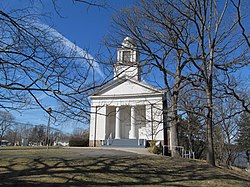
In 1860 Whitney's son, Eli Whitney Jr., completely rebuilt the factory and increased the height of the mill dam. This provided more water power and created Lake Whitney, the first municipal water supply for New Haven. He was also a financial supporter of Whitneyville Congregational Church, almost a mile north of the factory, and the neighborhood center began to shift there. By 1900 the electric trolley line from New Haven reached Whitneyville, leading to the subdivision of surrounding land for residential development. The neighborhood street network was substantially complete by 1927. [5] Houses continued to be built well into the twentieth century, notably several distinctive modern homes on Deepwood Drive, [6] and the last house in which playwright Thornton Wilder lived. [7]

Historic sites

These locations in the neighborhood are listed on the National Register of Historic Places:

Government

The Town of Hamden provides all municipal services for the neighborhood. It is located in Connecticut's 3rd congressional district. Most of the neighborhood is in the 11th state senate district, with a small western portion in the 17th, and most of it is in the 91st state house district, with a small western portion in the 94th. It is in the 5th district of the town legislative council. [8] It is served by the Whitneyville post office with ZIP code 06517.

Transportation

Whitney Avenue extends north and south through the neighborhood with Putnam Avenue extending to the west from Whitney. The nearest expressway interchanges are on the Wilbur Cross Parkway (Route 15) in Hamden or I-91 in New Haven.

CT Transit operates the 228 and 229 bus routes on Whitney Avenue and the 234 route on Putnam Avenue and several other neighborhood streets. [9]

Farmington Canal Greenway, a segment of East Coast Greenway, extends along the western edge of Whitneyville with an entrance on Putnam Avenue.

Education

Educational facilities in the neighborhood include Hamden Hall Country Day School, a private, coeducational school for prekindergarten to grade 12, and the Children's Center of Hamden, a residential facility for children and teenagers with learning disabilities and other challenges. [10] The central offices of the Hamden public schools are located in the former Putnam Avenue School building.

A small portion of the campus of Albertus Magnus College in New Haven extends into the neighborhood.

Recreation

There are two town parks in the neighborhood. [11] DeNicola Park has a playground, multisport field, and basketball courts. Villano Park has a playground, splash pad, multisport field, and basketball and tennis courts. The adjoining Rochford Field has baseball and softball fields used by Albertus Magnus.

Related Research Articles

<span class="mw-page-title-main">New Haven, Connecticut</span> City in Connecticut, United States

New Haven is a city in New Haven County, Connecticut, United States. It is located on New Haven Harbor on the northern shore of Long Island Sound and is part of the New York City metropolitan area. With a population of 135,081 as determined by the 2020 U.S. census, New Haven is the third largest city in Connecticut after Bridgeport and Stamford, the largest city in the South Central Connecticut Planning Region, and the principal municipality of Greater New Haven, which had a total population of 864,835 in 2020. Prior to 1960, it was the county seat of New Haven County until the county governments were abolished that year.

<span class="mw-page-title-main">Hamden, Connecticut</span> Town in Connecticut, United States

Hamden is a town in New Haven County, Connecticut, United States. The town's nickname is "The Land of the Sleeping Giant". The town is part of the South Central Connecticut Planning Region. The population was 61,169 at the 2020 census.

East Rock of south-central Connecticut, United States, with a high point of 366 feet (112 m), is a 1.4-mile (2 km) long trap rock ridge located primarily in the neighborhood of East Rock on the north side of the city of New Haven. A prominent landscape feature and a popular outdoor recreation area with cliffs that rise 300 feet (91 m) over the city below, East Rock is part of the narrow, linear Metacomet Ridge that extends from Long Island Sound near New Haven, north through the Connecticut River Valley of Massachusetts to the Vermont border. East Rock is the central feature of East Rock Park, a municipal park owned by the city of New Haven along the New Haven-Hamden town line.

<span class="mw-page-title-main">East Rock, New Haven</span> Neighborhood of New Haven in Connecticut, United States

East Rock is a neighborhood in the city of New Haven, Connecticut, named for nearby East Rock, a prominent trap rock ridge. The area is home to a large group of Yale students, staff, and faculty, as well as many young professionals and families. Writing in the Times Literary Supplement, Hirsh Sawhney describes East Rock as a "yuppie enclave", which is "increasingly composed of wealthy professionals and graduate students, most of whom are affiliated with Yale University, whose lavish campus lies just over a mile away" East Rock is also a popular destination for cyclists, as a city bike lane runs along Orange Street, the neighborhood's spine. East Rock is the safest neighborhood in New Haven County. East Rock is home to East Rock Park, which is frequently visited by families and tourists.

<span class="mw-page-title-main">Mill River (Connecticut)</span> River in New Haven County, Connecticut, United States

The Mill River is a river in New Haven County, Connecticut, United States.

<span class="mw-page-title-main">Eli Whitney Museum</span> Museum in Hamden, Connecticut, USA

The Eli Whitney Museum, in Hamden, Connecticut, is an experimental learning workshop for students, teachers, and families. The museum's main building is located on a portion of the Eli Whitney Gun Factory site, a gun factory erected by Eli Whitney in 1798. The museum focuses on teaching experiments that are the roots of design and invention, featuring hands-on building projects and exhibits on Whitney and A. C. Gilbert.

<span class="mw-page-title-main">Farmington Canal</span> Former canal in Connecticut and Massachusetts

The Farmington Canal, also known as the New Haven and Northampton Canal, was a major private canal built in the early 19th century to provide water transportation from New Haven into the interior of Connecticut, Massachusetts and beyond. Its Massachusetts segment was known as the Hampshire and Hampden Canal. With the advent of railroads, it was quickly converted to a railroad in the mid-19th century and in recent years has been converted to a multi-use trail after being abandoned for years.

<span class="mw-page-title-main">Connecticut Route 10</span> State highway in Connecticut, US

Connecticut Route 10 is a state highway that runs between New Haven and the state line near Granby. It continues north of the state line as Massachusetts Route 10, which in turn continues directly to New Hampshire Route 10.

<span class="mw-page-title-main">Cedar Hill (New Haven)</span>

Cedar Hill is a neighborhood in New Haven, Connecticut. It includes portions of the city-designated neighborhoods of East Rock, Quinnipiac Meadows, and Mill River. Cedar Hill was named for cedar trees that were once plentiful there in 1665. The area was divided from the local surroundings by the construction of I-91 in the 1960s. Cedar Hill's boundary runs from James Street, up the Mill River, to Rice Field, over Indian Head Rock, to the Hamden town line, across to Middletown Avenue, to the Eastern side of State Street, back up to James Street.

Dixwell is a neighborhood of New Haven, Connecticut. Named for Dixwell Avenue, the main thoroughfare of the neighborhood which in turn was named for regicide judge John Dixwell, it is situated generally northwest of and adjacent to Downtown New Haven.

Newhallville is a neighborhood in the city of New Haven, Connecticut, named for industrialist George Newhall.

<span class="mw-page-title-main">Farmington Canal Heritage Trail</span>

The Farmington Canal Heritage Trail is an 81.2-mile (130.7 km) multi-use rail trail located in Connecticut and Massachusetts.

<span class="mw-page-title-main">Prospect Hill, New Haven</span> Historic district in Connecticut, United States

Prospect Hill is a neighborhood of the city of New Haven, Connecticut located in the north central portion of the city, directly north of Downtown New Haven. The neighborhood contains residences, institutional buildings of Albertus Magnus College and a portion of the main campus of Yale University, including the Science Hill area, the Hillhouse Avenue area and the Yale Peabody Museum. The City of New Haven defines the neighborhood to be the region bounded by the town of Hamden in the north, Winchester Avenue in the west, Munson Street/Hillside Place/Prospect Street in the southwest, Trumbull Street in the south, and Whitney Avenue in the east. Prospect Street is the main thoroughfare through the neighborhood.

<span class="mw-page-title-main">Whitneyville Congregational Church (Hamden, Connecticut)</span> Historic church in Connecticut, United States

The Whitneyville Congregational Church, now the Whitneyville United Church of Christ, is a historic Congregational Church at 1247-1253 Whitney Avenue in the Whitneyville section of Hamden, Connecticut. The congregation is now affiliated with the United Church of Christ (UCC). The church building is a Greek Revival style built in 1834, with an interior altered in 1866 to designs by Rufus G. Russell. The church, along with its 1924 parish house, was added to the National Register of Historic Places in 1995 for its architecture.

Whitney Avenue is a principal arterial connecting Downtown New Haven with the town center of Hamden in the U.S. state of Connecticut. Most of the road within the city of New Haven is included in the Whitney Avenue Historic District, which is listed on the National Register of Historic Places. The designation begins at Grove Street in the northern part of Downtown New Haven and extends through the town of Hamden up to the Cheshire town line. North of Dixwell Avenue in Hamden Center, the road is a state highway and designated as part of Route 10. From the New Haven town line to Dixwell Avenue, the road is state-maintained with an unsigned designation of State Road 707. Within New Haven, Whitney Avenue is a town road. The J route of Connecticut Transit New Haven, which connects New Haven to Waterbury, runs along Whitney Avenue.

<span class="mw-page-title-main">Farmington Canal State Park Trail</span> Connecticut Nature Trail

Farmington Canal State Park Trail is a Connecticut state park forming a portion of the Farmington Canal Heritage Trail in the towns of Cheshire and Hamden. The developed section of the trail within state park boundaries runs over 17.0 miles (27.4 km) from Lazy Lane in Southington to Todd Street in Hamden and includes the historic Farmington Canal's restored Lock 12, located south of Brooksvale Road in Cheshire. The paved, multiple-use trail is used for hiking, biking, jogging, in-line skating and cross-country skiing.

<span class="mw-page-title-main">Mount Carmel, Hamden</span> Neighborhood in New Haven, Connecticut, United States

Mount Carmel is a neighborhood in the northeastern portion of the town of Hamden, Connecticut. It was the site of the first meeting house in what is now Hamden. Its founders named the area due to the resemblance of a range of hills nearby to the Mount Carmel mentioned in the Bible. The hills are better known today as the Sleeping Giant, site of a large state park known for its system of hiking trails. The neighborhood also contains the principal campus of Quinnipiac University. It is primarily residential with single-family homes. Commercial development is mostly along its principal street, Whitney Avenue.

<span class="mw-page-title-main">Centerville, Hamden</span> Neighborhood in New Haven, Connecticut, United States

Centerville, originally spelled Centreville, is a neighborhood in the east-central portion of the town of Hamden, Connecticut. It is the location of Hamden Town Hall and other major town government buildings. It derived its name from being at the intersection of the town's two principal thoroughfares, Whitney and Dixwell avenues, both with commercial development. The rest of the neighborhood is residential, with single-family houses, condominiums, and apartments.

<span class="mw-page-title-main">Highwood, Hamden</span> Neighborhood in New Haven, Connecticut, United States

Highwood is a neighborhood in the south-central portion of the town of Hamden, Connecticut. It is primarily residential, with a mixture of small apartment buildings and single-family, two- and three-family homes. Commercial development is concentrated on its principal street, Dixwell Avenue. Immigrants from Germany were the first to settle the area extensively in the 1860s, followed by others from Ireland, Italy, and Eastern Europe later in the nineteenth century. Today it is predominantly African American.

<span class="mw-page-title-main">Spring Glen, Hamden</span> Neighborhood in New Haven, Connecticut, United States

Spring Glen is a neighborhood in the southeastern portion of the town of Hamden, Connecticut. It is primarily residential, mostly single-family homes with a few two-family. Commercial development is entirely on its principal street, Whitney Avenue. It was developed throughout the first half of the twentieth century as a trolley suburb of New Haven. It was named for the Spring Glen dairy farm established by James J. Webb in 1858 in what would become part of the neighborhood.

References

  1. Becker, Martha May (1986). Hamden: Our Architectural Heritage. Whitney Press. p. 23.
  2. "Neighborhood Scout overview of Whitneyville".
  3. Hartley, Rachel (1959). The History of Hamden, Connecticut, 1786-1959. Map in frontispiece.
  4. Lehman, Eric D. (2010). Hamden: Tales from the Sleeping Giant. History Press. p. 21. ISBN   978-1-59629-835-4.
  5. Map showing streets in a portion of Town of Hamden. Proctor & Way. 1927.
  6. Brown, Elizabeth Mills (1976). New Haven: A Guide to Architecture and Urban Design. Yale University Press. pp. 37–38. ISBN   0-300-01993-9.
  7. "Thornton Wilder House (1929)".
  8. "Hamden district maps".
  9. "CT Transit New Haven local system map" (PDF).
  10. "Children's Center of Hamden".
  11. "Hamden town parks".