
Sir Joseph Whitworth, 1st Baronet was an English engineer, entrepreneur, inventor and philanthropist. In 1841, he devised the British Standard Whitworth system, which created an accepted standard for screw threads. Whitworth also created the Whitworth rifle, often called the "sharpshooter" because of its accuracy, which is considered one of the earliest examples of a sniper rifle.

Bakewell is a market town and civil parish in the Derbyshire Dales district of Derbyshire, England, known also for its local Bakewell pudding. It lies on the River Wye, about 13 miles (21 km) south-west of Sheffield. In the 2011 census, the population of the civil parish appeared as 3,949. It was estimated at 3,695 in 2019. The town is close to the tourist attractions of Chatsworth House and Haddon Hall.

Matlock is the county town of Derbyshire, England. It is situated in the south-eastern part of the Peak District, with the National Park directly to the west. The town is twinned with the French town of Eaubonne. The former spa resort of Matlock Bath lies immediately south of the town on the A6. The civil parish of Matlock Town had a population in the 2011 UK census of 9,543. The population of the wider Matlock urban area is approximately 20,000.

Youlgreave or Youlgravelisten (help·info) is a village and civil parish in the Peak District of Derbyshire, England, on the River Bradford 2+1⁄2 miles (4.0 km) south of Bakewell. The name possibly derives from "yellow grove", the ore mined locally being yellow in colour. The population in 1991 was 1,256; it is one of the largest villages in the Peak District National Park.

Darley Dale, also known simply as Darley, is a town and civil parish in the Derbyshire Dales district of Derbyshire, England, with a population of around 6,000. It lies north of Matlock, on the River Derwent and the A6 road. The town forms part of the urban area of Matlock and acts as a commuter town for workers there.
Peak Rail is a preserved railway in Derbyshire, England, which operates a steam and heritage diesel service for tourists and visitors to both the Peak District and the Derbyshire Dales.

Chesterfield railway station serves the town of Chesterfield in Derbyshire, England. It lies on the Midland Main Line. Four tracks pass through the station which has three platforms. It is currently operated by East Midlands Railway.

Cromford railway station is a Grade II listed railway station owned by Network Rail and managed by East Midlands Railway. It is located in the village of Cromford in Derbyshire, England. The station is on the Derwent Valley Line 15+1⁄2 miles (24.9 km) north of Derby towards Matlock.

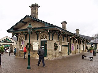
Matlock Railway Station is a railway station owned by Network Rail and managed by East Midlands Railway in the Derbyshire Dales town of Matlock, Derbyshire, England. The station is the terminus of both the Derwent Valley Line from Derby and Peak Rail who operate heritage services to Rowsley South. Both lines are formed from portions of the Midland Railway's former main line to Manchester Central. Through running is technically possible but is not done in normal service.

Millers Dale railway station was situated in Millers Dale, near Tideswell, in the Peak District.

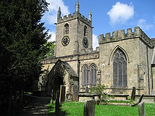
All Saints' Church, Bakewell, is the parish church of Bakewell, Derbyshire. It is a Grade I listed building.

Matlock Cable Tramway was a cable tramway that served the town of Matlock, Derbyshire, UK between 28 March 1893 and 30 September 1927.

Uttley House, is a Grade II listed building and Halls of residence in Fallowfield, Manchester, England. It was designed and built in 1850 by Edward Walters, who was also responsible for Manchester’s Free Trade Hall. Originally a home for Sir Joseph Whitworth, The house is surrounded by five and a half acres of gardens to the south and an environmental research institute to the north. The house has seen many past uses, including a private home, hotel, vaccination clinic and conference centre.
The Monsal Trail is a cycling, horse riding and walking trail in the Derbyshire Peak District. It was constructed from a section of the former Manchester, Buxton, Matlock and Midland Junction Railway, which was built by the Midland Railway in 1863 to link Manchester with London and closed in 1968. The Monsal Trail is about 8.5 miles (13.7 km) long and opened in 1981. It starts at the Topley Pike junction in Wye Dale, 3 miles (4.8 km) east of Buxton, and runs to Coombs Viaduct, 1 mile (1.6 km) south-east of Bakewell. It follows the valley of the River Wye. The trail passes through Blackwell Mill, Chee Dale, Millers Dale, Cressbrook, Monsal Dale, Great Longstone, Hassop and Bakewell. The trail has numerous landmarks including Headstone Viaduct, Cressbrook Mill, Litton Mill and Hassop railway station, and passes through six tunnels.

Great Longstone for Ashford railway station was a station which served Great and Little Longstone in the Peak District of Derbyshire. It was opened in 1863 by the Midland Railway on its extension of the Manchester, Buxton, Matlock and Midlands Junction Railway from Rowsley.
The original Rowsley railway station was opened in 1849 by the Manchester, Buxton, Matlock and Midlands Junction Railway to serve the village of Rowsley in Derbyshire.
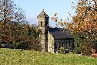
St Helen's Church, Darley Dale is a Grade II* listed parish church in the Church of England in Darley Dale, Derbyshire.
St Mary the Virgin's Church, South Darley is a Grade II listed parish church in the Church of England in South Darley, Derbyshire. At the entrance to the churchyard is a memorial to the men from the parish who died in the two world wars.

Northwood and Tinkersley is a civil parish within the Derbyshire Dales district, in the county of Derbyshire, England. Named for its main settlements, with a mix of rural and built up areas, it had a population of 665 residents in 2011. The parish is 126 miles (203 km) north west of London, 18 miles (29 km) north west of the county city of Derby, and 3+1⁄2 miles (5.6 km) north west of the nearest market town of Matlock. Northwood and Tinkersley is directly adjacent to the Peak District national park to the west, and shares a border with the parishes of Darley Dale, Rowsley and Stanton.
Darley Dale is a civil parish in the Derbyshire Dales district of Derbyshire, England. The parish contains 27 listed buildings that are recorded in the National Heritage List for England. Of these, three are listed at Grade II*, the middle of the three grades, and the others are at Grade II, the lowest grade. The parish contains the town of Darley Dale and the surrounding area. Most of the listed buildings are houses, cottages and associated structures, farmhouses and farm buildings. The other listed buildings include a church and its former rectory, a road bridge over the River Derwent, public houses, a mile post and a milestone, buildings associated with Darley Dale railway station, an institute, and a school.

