Amalka is a village in the administrative district of Gmina Sulęczyno, within Kartuzy County, Pomeranian Voivodeship, in northern Poland. It lies approximately 6 kilometres (4 mi) north-east of Sulęczyno, 27 km (17 mi) west of Kartuzy, and 55 km (34 mi) west of the regional capital Gdańsk.
Bielawki is a village in the administrative district of Gmina Sulęczyno, within Kartuzy County, Pomeranian Voivodeship, in northern Poland. It lies approximately 6 kilometres (4 mi) north of Sulęczyno, 29 km (18 mi) west of Kartuzy, and 57 km (35 mi) west of the regional capital Gdańsk.
Borek is a village in the administrative district of Gmina Sulęczyno, within Kartuzy County, Pomeranian Voivodeship, in northern Poland. It lies approximately 6 kilometres (4 mi) north of Sulęczyno, 27 km (17 mi) west of Kartuzy, and 55 km (34 mi) west of the regional capital Gdańsk.
Borek Kamienny is a village in the administrative district of Gmina Sulęczyno, within Kartuzy County, Pomeranian Voivodeship, in northern Poland. It lies approximately 5 kilometres (3 mi) north of Sulęczyno, 30 km (19 mi) west of Kartuzy, and 58 km (36 mi) west of the regional capital Gdańsk.
Borowiec is a village in the administrative district of Gmina Sulęczyno, within Kartuzy County, Pomeranian Voivodeship, in northern Poland. It lies approximately 9 kilometres (6 mi) east of Sulęczyno, 24 km (15 mi) south-west of Kartuzy, and 51 km (32 mi) west of the regional capital Gdańsk.
Bukowa Góra is a village in the administrative district of Gmina Sulęczyno, within Kartuzy County, Pomeranian Voivodeship, in northern Poland. It lies approximately 4 kilometres (2 mi) north-east of Sulęczyno, 28 km (17 mi) west of Kartuzy, and 56 km (35 mi) west of the regional capital Gdańsk.
Chojna is a village in the administrative district of Gmina Sulęczyno, within Kartuzy County, Pomeranian Voivodeship, in northern Poland. It lies approximately 7 kilometres (4 mi) north-west of Sulęczyno, 32 km (20 mi) west of Kartuzy, and 60 km (37 mi) west of the regional capital Gdańsk.
Czarlino is a village in the administrative district of Gmina Sulęczyno, within Kartuzy County, Pomeranian Voivodeship, in northern Poland. It lies approximately 8 kilometres (5 mi) east of Sulęczyno, 26 km (16 mi) south-west of Kartuzy, and 53 km (33 mi) west of the regional capital Gdańsk.
Kistowo is a village in the administrative district of Gmina Sulęczyno, within Kartuzy County, Pomeranian Voivodeship, in northern Poland. It lies approximately 4 kilometres (2 mi) north of Sulęczyno, 31 km (19 mi) west of Kartuzy, and 59 km (37 mi) west of the regional capital Gdańsk.
Kłodno is a village in the administrative district of Gmina Sulęczyno, within Kartuzy County, Pomeranian Voivodeship, in northern Poland. It lies approximately 3 kilometres (2 mi) south of Sulęczyno, 32 km (20 mi) south-west of Kartuzy, and 60 km (37 mi) west of the regional capital Gdańsk.
Kołodzieje is a village in the administrative district of Gmina Sulęczyno, within Kartuzy County, Pomeranian Voivodeship, in northern Poland. It lies approximately 4 kilometres (2 mi) north-west of Sulęczyno, 32 km (20 mi) west of Kartuzy, and 60 km (37 mi) west of the regional capital Gdańsk.
Mściszewice is a village in the administrative district of Gmina Sulęczyno, within Kartuzy County, Pomeranian Voivodeship, in northern Poland. It lies approximately 7 kilometres (4 mi) north-east of Sulęczyno, 24 km (15 mi) west of Kartuzy, and 52 km (32 mi) west of the regional capital Gdańsk.
Nowy Dwór is a village in the administrative district of Gmina Sulęczyno, within Kartuzy County, Pomeranian Voivodeship, in northern Poland. It lies approximately 3 kilometres (2 mi) south-west of Sulęczyno, 33 km (21 mi) south-west of Kartuzy, and 61 km (38 mi) west of the regional capital Gdańsk.
Ostrów-Mausz is a village in the administrative district of Gmina Sulęczyno, within Kartuzy County, Pomeranian Voivodeship, in northern Poland. It lies approximately 5 km (3 mi) south-west of Sulęczyno, 35 km (22 mi) south-west of Kartuzy, and 62 km (39 mi) west of the regional capital Gdańsk.
Ostrowite is a village in the administrative district of Gmina Sulęczyno, within Kartuzy County, Pomeranian Voivodeship, in northern Poland. It lies approximately 5 kilometres (3 mi) south-east of Sulęczyno, 29 km (18 mi) south-west of Kartuzy, and 56 km (35 mi) west of the regional capital Gdańsk.
Sucha is a village in the administrative district of Gmina Sulęczyno, within Kartuzy County, Pomeranian Voivodeship, in northern Poland. It lies approximately 3 kilometres (2 mi) north-west of Sulęczyno, 33 km (21 mi) west of Kartuzy, and 61 km (38 mi) west of the regional capital Gdańsk.

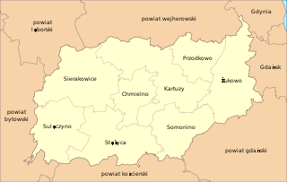
Sulęczyno is a village in Kartuzy County, Pomeranian Voivodeship, in northern Poland. It is the seat of the gmina called Gmina Sulęczyno. It lies approximately 31 kilometres (19 mi) west of Kartuzy and 59 km (37 mi) west of the regional capital Gdańsk.

Węsiory is a village in the administrative district of Gmina Sulęczyno, within Kartuzy County, Pomeranian Voivodeship, in northern Poland. The village lies approximately 5 kilometres (3 mi) east of Sulęczyno, 26 km (16 mi) south-west of Kartuzy, and 54 km (34 mi) west of the regional capital Gdańsk. It has a population of 754.
Żakowo is a village in the administrative district of Gmina Sulęczyno, within Kartuzy County, Pomeranian Voivodeship, in northern Poland. It lies approximately 3 kilometres (2 mi) north of Sulęczyno, 29 km (18 mi) west of Kartuzy, and 57 km (35 mi) west of the regional capital Gdańsk.
Zdunowice Małe is a village in the administrative district of Gmina Sulęczyno, within Kartuzy County, Pomeranian Voivodeship, in northern Poland. It lies approximately 5 kilometres (3 mi) south-east of Sulęczyno, 30 km (19 mi) south-west of Kartuzy, and 58 km (36 mi) west of the regional capital Gdańsk.