Ganzourgou is a province of Burkina Faso and is in Plateau-Central Region. The capital of Ganzourgou is Zorgho, which is along the road between Ouagadougou and Niamey, Niger. Other important localities in the province are Mogtédo and Méguet. The population of Ganzourgou in 2006 was 319,830.
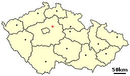
Předměřice nad Jizerou is a village in the Central Bohemian Region of the Czech Republic. It has around 700 inhabitants. Village Kačov is administrative part of Předměřice nad Jizerou.

Lubnów is a village in the administrative district of Gmina Oborniki Śląskie, within Trzebnica County, Lower Silesian Voivodeship, in south-western Poland. Prior to 1945 it was in Germany.
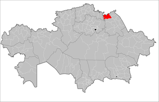
Ertis is a district of Pavlodar Region in northern Kazakhstan. The administrative center of the district is the selo of Ertis. Population: 19,037 ; 20,853 ; 33,129.
Gusin is a village in Otwock County, Gmina Sobienie-Jeziory.The population is near 200.
Piaski is a village in the administrative district of Gmina Grudziądz, within Grudziądz County, Kuyavian-Pomeranian Voivodeship, in north-central Poland. It lies approximately 9 kilometres (6 mi) south of Grudziądz and 45 km (28 mi) north of Toruń.
Brzozowy Kąt is a village in the administrative district of Gmina Komarówka Podlaska, within Radzyń Podlaski County, Lublin Voivodeship, in eastern Poland. It lies approximately 5 kilometres (3 mi) south-east of Komarówka Podlaska, 27 km (17 mi) east of Radzyń Podlaski, and 67 km (42 mi) north-east of the regional capital Lublin.
Romanówka is a village in the administrative district of Gmina Dwikozy, within Sandomierz County, Świętokrzyskie Voivodeship, in south-central Poland. It lies approximately 7 kilometres (4 mi) north-west of Dwikozy, 12 km (7 mi) north of Sandomierz, and 80 km (50 mi) east of the regional capital Kielce.
Nowy Dzierzkówek is a village in the administrative district of Gmina Skaryszew, within Radom County, Masovian Voivodeship, in east-central Poland.
Kościelna Wieś is a village in the administrative district of Gmina Gołuchów, within Pleszew County, Greater Poland Voivodeship, in west-central Poland. It lies approximately 9 kilometres (6 mi) south-east of Gołuchów, 19 km (12 mi) south-east of Pleszew, and 102 km (63 mi) south-east of the regional capital Poznań.
Stołczno is a village in the administrative district of Gmina Człuchów, within Człuchów County, Pomeranian Voivodeship, in northern Poland. It lies approximately 10 kilometres (6 mi) north-west of Człuchów and 116 km (72 mi) south-west of the regional capital Gdańsk.
Borcz-Leśniczówka is a settlement in the administrative district of Gmina Somonino, within Kartuzy County, Pomeranian Voivodeship, in northern Poland. It lies approximately 7 kilometres (4 mi) east of Somonino, 10 km (6 mi) south-east of Kartuzy, and 26 km (16 mi) south-west of the regional capital Gdańsk.
Pstra Suka is a settlement in the administrative district of Gmina Somonino, within Kartuzy County, Pomeranian Voivodeship, in northern Poland. It lies approximately 5 kilometres (3 mi) south-east of Somonino, 10 km (6 mi) south-east of Kartuzy, and 27 km (17 mi) south-west of the regional capital Gdańsk.
Sarni Dwór-Leśniczówka is a settlement in the administrative district of Gmina Somonino, within Kartuzy County, Pomeranian Voivodeship, in northern Poland. It lies approximately 5 kilometres (3 mi) south-east of Somonino, 10 km (6 mi) south-east of Kartuzy, and 27 km (17 mi) south-west of the regional capital Gdańsk.
Bąsewice is a village in the administrative district of Gmina Nowa Wieś Lęborska, within Lębork County, Pomeranian Voivodeship, in northern Poland. It lies approximately 13 kilometres (8 mi) north of Nowa Wieś Lęborska, 14 km (9 mi) north of Lębork, and 65 km (40 mi) north-west of the regional capital Gdańsk.
Gardno is a village in the administrative district of Gmina Gryfino, within Gryfino County, West Pomeranian Voivodeship, in north-western Poland, close to the German border. It lies approximately 10 kilometres (6 mi) east of Gryfino and 18 km (11 mi) south of the regional capital Szczecin.
Iłowo is a settlement in the administrative district of Gmina Myślibórz, within Myślibórz County, West Pomeranian Voivodeship, in north-western Poland.
Cybulin is a settlement in the administrative district of Gmina Biały Bór, within Szczecinek County, West Pomeranian Voivodeship, in north-western Poland. It lies approximately 10 kilometres (6 mi) north of Biały Bór, 30 km (19 mi) north of Szczecinek, and 158 km (98 mi) north-east of the regional capital Szczecin.
Libenice is a village and municipality in Kolín District in the Central Bohemian Region of the Czech Republic.
Aïn Zouit is a town and commune in Skikda Province in north-eastern Algeria.