Wilcox, Pennsylvania

Last updated

Wilcox, Pennsylvania
Wilcox PO Apr 10.JPG
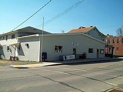
U.S. Post Office and Jones Township Municipal Authority, Wilcox, Pennsylvania, April 2010
USA Pennsylvania location map.svg
Red pog.svg
Wilcox
Location within the U.S. state of Pennsylvania
Usa edcp location map.svg
Red pog.svg
Wilcox
Wilcox (the United States)
Coordinates: 41°34′32″N78°41′18″W / 41.57556°N 78.68833°W / 41.57556; -78.68833
Country United States
State Pennsylvania
County Elk
Township Jones
Area
  Total0.5 sq mi (1.3 km2)
  Land0.5 sq mi (1.3 km2)
  Water0.0 sq mi (0.0 km2)
Elevation
1,526 ft (465 m)
Population
  Total354
  Density746/sq mi (288.2/km2)
Time zone UTC-5 (Eastern (EST))
  Summer (DST) UTC-4 (EDT)
ZIP code
15870
FIPS code 42-85088
GNIS feature ID1210116

Wilcox is a census-designated place located in Jones Township, Elk County, Pennsylvania, United States. [1] The community was named after a settler, Col. A.I. Wilcox. As of the 2020 census, Wilcox had a population of 354. [2] [3]

Contents

Wilcox is located in the west-central part of Jones Township in northern Elk County, in the valley of the West Branch of the Clarion River, a tributary of the Allegheny River. U.S. Route 219 passes through the center of town, leading north 29 miles (47 km) to Bradford and south 14 miles (23 km) to Ridgway, the Elk County seat. Pennsylvania Route 321 leads northwest from Wilcox 9 miles (14 km) to Kane. The Swedish Lutheran Parsonage located at 230 Kane Street was added to the National Register of Historic Places in 2005. [4]

The year 2008 marked the 150th anniversary of the settlement of this village. Wilcox is located on the Allegheny Plateau near the East Branch Clarion River Lake. Over 250,000 visitors a year come to Wilcox to enjoy the natural foresting, fishing, hunting, and three state and national parks.[ citation needed ]

See also

Related Research Articles

<span class="mw-page-title-main">Warren County, Pennsylvania</span> County in Pennsylvania, United States

Warren County is a county in the Commonwealth of Pennsylvania. As of the 2020 census, the population was 38,587. Its county seat is Warren. The county was established in 1800 from parts of Allegheny and Lycoming counties; attached to Crawford County until 1805 and then to Venango County until Warren was formally established in 1819.

<span class="mw-page-title-main">McKean County, Pennsylvania</span> County in Pennsylvania, United States

McKean County is a rural county in the Commonwealth of Pennsylvania. As of the 2020 census, the population was 40,432. Its county seat is Smethport. The county was created in 1804 and organized in 1826. It was named in honor of former Pennsylvania Governor and Declaration of Independence signer Thomas McKean. The county is part of the North Central Pennsylvania region of the state.

<span class="mw-page-title-main">Elk County, Pennsylvania</span> County in Pennsylvania, United States

Elk County is a county in the Commonwealth of Pennsylvania. As of the 2020 United States census, the population was 30,990. Its county seat is Ridgway. The county was created on April 18, 1843, from parts of Jefferson, Clearfield, and McKean Counties. Elk County is named for the now-extinct eastern elk that historically inhabited the region. The county is part of the North Central Pennsylvania region of the state.

<span class="mw-page-title-main">Washington Township, Armstrong County, Pennsylvania</span> Township in Pennsylvania, United States

Washington Township is a township in Armstrong County, Pennsylvania, United States. The population was 898 at the 2020 census, a decrease from 923 at the 2010 census.

<span class="mw-page-title-main">Cresson Township, Cambria County, Pennsylvania</span> Township in Pennsylvania, United States

Cresson Township is a township in Cambria County, Pennsylvania, United States. The population was 2,820 at the 2020 census. The township surrounds the boroughs of Cresson and Sankertown but is separate from them. It is part of the Johnstown, Pennsylvania Metropolitan Statistical Area.

<span class="mw-page-title-main">Portage Township, Cambria County, Pennsylvania</span> Township in Pennsylvania, United States

Portage Township is a township in Cambria County, Pennsylvania, United States. It surrounds the borough of Portage. The township population was 3,640 at the 2010 census. It is part of the Johnstown, Pennsylvania Metropolitan Statistical Area.

<span class="mw-page-title-main">Clarion, Pennsylvania</span> Borough in Pennsylvania, United States

Clarion is a borough in and the county seat of Clarion County, Pennsylvania, United States. It is located 77 miles (124 km) north-northeast of Pittsburgh and is part of the Pittsburgh DMA. Clarion was settled in 1839 and incorporated in 1841. In the past, the surrounding area produced natural gas, oil, lumber and coal. The population was 2,004 in 1900, 2,864 in 1910, and 3,931 at the 2020 census, down from 5,276 at the 2010 census. It is home to the annual Autumn Leaf Festival and PennWest Clarion. The county courthouse was added to the National Register of Historic Places in 1979. Clarion County's designated tourism agency is Discover Clarion County.

<span class="mw-page-title-main">Clearfield, Pennsylvania</span> Borough in Pennsylvania, United States

Clearfield is a borough and the county seat of Clearfield County, Pennsylvania, United States. As of the 2020 census the population was 5,962 people, making it the second most populous community in Clearfield County, behind DuBois. The borough is part of the DuBois, PA Micropolitan Statistical Area, as well as the larger State College-DuBois, PA Combined Statistical Area. The settled area surrounding the borough consists of the nearby census-designated places of Hyde and Plymptonville, which combined with Clearfield have a population of approximately 8,237 people.

<span class="mw-page-title-main">Jones Township, Elk County, Pennsylvania</span> Township in Pennsylvania, United States

Jones Township is a township in Elk County, Pennsylvania, United States. The population was 1,569 at the 2020 census, down from 1,624 in 2010. Bendigo State Park and part of Elk State Park are in Jones Township, on the East Branch of the Clarion River.

<span class="mw-page-title-main">Ridgway, Pennsylvania</span> Borough in Pennsylvania, United States

Ridgway is a borough in and the county seat of Elk County, Pennsylvania. As of the 2020 census it had a population of 4,039

<span class="mw-page-title-main">Snyder Township, Jefferson County, Pennsylvania</span> Township in Pennsylvania, United States

Snyder Township is a township in Jefferson County, Pennsylvania, United States. The population was 2,367 at the 2020 census. It was named for Governor of Pennsylvania Simon Snyder.

<span class="mw-page-title-main">Clarion River</span> River in the United States

The Clarion River is a tributary of the Allegheny River, approximately 110 mi (177 km) long, in west central Pennsylvania in the United States. It drains a rugged area of the Allegheny Plateau in the Ohio River watershed, flowing through narrow serpentine valleys and hardwood forests.

<span class="mw-page-title-main">Elk State Park</span>

Elk State Park is a 3,192-acre (1,292 ha) Pennsylvania state park in Jones Township, Elk County and Sergeant Township, McKean County, Pennsylvania, in the United States. East Branch Clarion River Lake is a man-made lake covering 1,160 acres (470 ha) within the park. The lake and streams in the park are stocked with cold and warm water fish. There are 3,151 acres (1,275 ha) of woods open to hunting.

<span class="mw-page-title-main">Raystown Branch Juniata River</span> River in Pennsylvania, United States

The Raystown Branch Juniata River is the largest and longest tributary of the Juniata River in south-central Pennsylvania in the United States.

<span class="mw-page-title-main">Pennsylvania Route 66</span> State highway in Pennsylvania, US

Pennsylvania Route 66 (PA 66) is a 139.7-mile-long (224.8 km) state highway in Western Pennsylvania. Its southern terminus is at U.S. Route 119 just east of Interstate 70 (I-70) near New Stanton. Its northern terminus is at US 6 in Kane.

<span class="mw-page-title-main">Pennsylvania Route 321</span> State highway in Elk and McKean counties in Pennsylvania, United States

Pennsylvania Route 321 (PA 321) is a 43.8-mile-long (70.5 km) state highway located in Elk and McKean counties in the U.S. state of Pennsylvania, maintained by the Pennsylvania Department of Transportation (PennDOT). The southern terminus is at U.S. Route 219 (US 219) in the community of Wilcox. The northern terminus is at PA 346 within the Allegheny National Forest. PA 321 heads northwest from Wilcox through rural areas to the borough of Kane, where it forms a brief concurrency with US 6. North of here, the route passes through the national forest and runs along the shore of the Allegheny Reservoir. PA 321 runs east briefly with PA 59 before winding north through more forest to its northern terminus. A portion of the route along the Allegheny Reservoir is designated as the Longhouse National Scenic Byway, a Pennsylvania Scenic Byway and National Forest Scenic Byway.

<span class="mw-page-title-main">Weedville, Pennsylvania</span> Census-designated place in Pennsylvania, United States

Weedville is an unincorporated community and census-designated place in Jay Township, Elk County, Pennsylvania, United States. As of the 2020 census, the population was 565.

<span class="mw-page-title-main">Marianne, Pennsylvania</span> Census designated place in Pennsylvania, United States

Marianne is a census-designated place located in Paint Township and Elk Township, Clarion County, in the U.S. state of Pennsylvania. The community is located at the intersections of Pennsylvania Route 66 and U.S. Route 322, approximately 1 mile (1.6 km) east of the borough of Shippenville and 3 miles (5 km) northwest of Clarion, the county seat. As of the 2010 census the population of Marianne was 1,167.

The Pennsylvania State Game Lands Number 25 are Pennsylvania State Game Lands in Elk County in Pennsylvania in the United States providing hunting, bird watching, and other activities.

The Pennsylvania State Game Lands Number 28 are Pennsylvania State Game Lands in Elk, Forest and Jefferson Counties in Pennsylvania in the United States providing hunting, bird watching, and other activities.

References

  1. U.S. Geological Survey Geographic Names Information System: Wilcox, Pennsylvania
  2. "Explore Census Data". data.census.gov.
  3. "Geographic Identifiers: 2010 Demographic Profile Data (G001): Wilcox CDP, Pennsylvania". American Factfinder. U.S. Census Bureau. Archived from the original on February 13, 2020. Retrieved March 14, 2016.
  4. "National Register Information System". National Register of Historic Places . National Park Service. March 13, 2009.