Wildlife Lane

Last updated

South Croom/Wildlife Lane
street and apparent neighborhood
Wildlife Lane; Hernando County, FL-10.jpg
Wildlife Lane and the intersection of High Corner Road in Hernando County, Florida
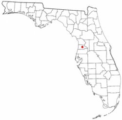
FLMap-doton-Brooksville.PNG
Country United States
Area
  Total
6 sq mi (12.9 miles km2)
  Land4.9 sq mi (12.8 km2)
  Water0.04 sq mi (0.1 km2)  0.60%
Population
[1]
  Total
454

Wildlife Lane is a street and apparent neighborhood in Hernando County, Florida. It is located along the north side of US 98-SR 50 east of Hill 'n Dale, Florida and west of Interstate 75 in Florida. It is also located along the southern edge of the Croom Tract of the Withlacoochee State Forest.

Demographics

As of the census [2] of 2000, there were 254 people, 220 households, and 245 families residing in the area. The population density was 34.2/km2 . There were 259 housing units. The racial makeup of the area was 98.2% White, .50% African American, 1.2% Native American, .1% Asian

There were 220 households, out of which 33.7% had children under the age of 18 living with them, 39.9% were married couples living together, 14.0% had a female householder with no husband present, and 43.1% were non-families. 38.0% of all households were made up of individuals, and 21.2% had someone living alone who was 65 years of age or older. The average household size was 2.14 and the average family size was 2.82.

In the area the population was spread out, with 22.1% under the age of 18, 7.8% from 18 to 24, 21.7% from 25 to 44, 18.7% from 45 to 64, and 29.7% who were 65 years of age or older. The median age was 44 years.

The median income for a household in the area was $33,489, and the median income for a family was $31,060. Males had a median income of $29,837 versus $21,804 for females. The per capita income for the area was $16,265. About 16.8% of families and 21.5% of the population were below the poverty line, including 27.9% of those under age 18 and 11.5% of those age 65 or over.

Related Research Articles

<span class="mw-page-title-main">Trafford, Alabama</span> Town in Alabama, United States

Trafford is a town in Jefferson County, Alabama, United States. A small portion extends into Blount County. The town was incorporated in 1948. At the 2020 census, the population was 613.

Village Park was a census-designated place (CDP) in Broward County, Florida, United States. The population was 895 at the 2000 census. It is now a part of North Lauderdale, Florida.

<span class="mw-page-title-main">Washington Park, Florida</span> CDP in Florida, United States

Washington Park is a census-designated place (CDP) in Broward County, Florida, United States. Its population was 1,948 at the 2020 census. It is home to the African-American Research Library and Cultural Center.

<span class="mw-page-title-main">Brookridge, Florida</span> Census-designated place in Florida, United States

Brookridge is a census-designated place (CDP) in Hernando County, Florida, United States. The population was 4,420 at the 2010 census, up from 3,279 at the 2000 census.

<span class="mw-page-title-main">High Point, Hernando County, Florida</span> Census-designated place in Florida, United States

High Point is an unincorporated area and census-designated place (CDP) in Hernando County, Florida, United States. The population was 3,686 at the 2010 census.

<span class="mw-page-title-main">Hill 'n Dale, Florida</span> Census-designated place in Florida, United States

Hill 'n Dale is a census-designated place (CDP) in Hernando County, Florida, United States. The population was 1,934 at the 2010 census.

<span class="mw-page-title-main">North Brooksville, Florida</span> Census-designated place in Florida, United States

North Brooksville is a census-designated place (CDP) in Hernando County, Florida, United States. The population was 3,544 at the 2010 census. It is a suburb included in the Tampa-St. Petersburg-Clearwater, Florida Metropolitan Statistical Area.

<span class="mw-page-title-main">Ridge Manor, Florida</span> Census-designated place in Florida, United States

Ridge Manor is a census-designated place (CDP) in Hernando County, Florida, United States. The population was 4,513 at the 2010 census.

<span class="mw-page-title-main">Weeki Wachee Gardens, Florida</span> Census-designated place in Florida, United States

Weeki Wachee Gardens is a census-designated place (CDP) in Hernando County, Florida, United States. The population was 1,146 at the 2010 census.

<span class="mw-page-title-main">Matlacha, Florida</span> Census-designated place in Florida, United States

Matlacha is a census-designated place (CDP) in Lee County, Florida, United States. The CDP had a population of 598 at the 2020 census, down from 677 at the 2010 census. It is part of the Cape Coral-Fort Myers, Florida Metropolitan Statistical Area.

<span class="mw-page-title-main">Andrews, Levy County, Florida</span> Census-designated place in Florida, United States

Andrews is a census-designated place (CDP) in Levy County, Florida, United States. The population was 837 at the 2020 census, up from 798 at the 2010 census. It is part of the Gainesville, Florida Metropolitan Statistical Area.

<span class="mw-page-title-main">Inglis, Florida</span> Town in Florida, United States

Inglis is a town in Levy County, Florida, United States. It is on U.S. Highway 19 near the Cross Florida Greenway. As of the 2020 census, the town had a population of 1,476, up from 1,325 at the 2010 census. It is part of the Gainesville, Florida Metropolitan Statistical Area.

<span class="mw-page-title-main">Goldenrod, Florida</span> CDP in Orange and Seminole counties, Florida, United States

Goldenrod is a census-designated place (CDP) in Orange and Seminole counties in the U.S. state of Florida. The population was 12,039 at the 2010 census. It is part of the Orlando–Kissimmee–Sanford, Florida Metropolitan Statistical Area.

<span class="mw-page-title-main">Paradise Heights, Florida</span> Census-designated place in Florida, United States

Paradise Heights is a census-designated place and an unincorporated area in Orange County, Florida, United States. The population was 1,215 at the 2010 census. It is part of the Orlando–Kissimmee Metropolitan Statistical Area.

<span class="mw-page-title-main">Belleair Beach, Florida</span> City in Florida, United States

Belleair Beach is a city in Pinellas County, Florida, United States. It is part of Tampa–St. Petersburg–Clearwater Metropolitan Statistical Area, more commonly known as the Tampa Bay Area. The population was 1,633 at the 2020 census.

<span class="mw-page-title-main">Gandy, Florida</span> Place in Florida, United States

Gandy is an unincorporated community and former census-designated place (CDP) in Pinellas County, Florida, United States. The population was 2,031 at the 2000 census. It is named after George Gandy and the Gandy Bridge which connects the area to Tampa across Old Tampa Bay.

<span class="mw-page-title-main">Ridgecrest, Florida</span> Census-designated place in Florida, United States

Ridgecrest is a census-designated place (CDP) in Pinellas County, Florida, United States. The population was 2,966 at the 2020 census.

<span class="mw-page-title-main">Kathleen, Florida</span> Census-designated place in Florida, United States

Kathleen is a census-designated place (CDP) in Polk County, Florida, United States. The population was 3,280 at the 2000 census. It is part of the Lakeland–Winter Haven Metropolitan Statistical Area.

<span class="mw-page-title-main">Winston, Florida</span> Place in Florida, United States

Winston is a former census-designated place (CDP) in Polk County, Florida, United States. The population was 9,024 at the 2000 census. Most of the community's core is now part of neighboring Lakeland. It is part of the Lakeland–Winter Haven Metropolitan Statistical Area.

<span class="mw-page-title-main">Samsula-Spruce Creek, Florida</span> CDP in Florida, United States

Samsula-Spruce Creek is a census-designated place (CDP) in Volusia County, Florida, United States. The population was 5,047 at the 2010 census. While many households reside here, it is principally an agricultural area west of the cities of Port Orange and New Smyrna Beach.

References

  1. "Brooksville city, Florida - DP-1. Profile of General Demographic Characteristics:  2000". 2000 US Census. Archived from the original on February 12, 2020. Retrieved January 22, 2007.
  2. "U.S. Census website". United States Census Bureau . Retrieved January 31, 2008.

28°32′08″N82°15′45″W / 28.5356715°N 82.2625272°W / 28.5356715; -82.2625272