Related Research Articles

Chino Valley is a town in Yavapai County, Arizona, United States. According to the 2010 census, the population of the town is 10,817.

Williamson is a census-designated place (CDP) in Yavapai County, Arizona, United States. The population was 3,776 at the 2000 census and 6,196 at the 2020 census. The name "Wiliamson" is a misnomer, perhaps propagated by federal bureaucratic error; the area has long been known as "Williamson Valley" after the major road through the area, Williamson Valley Road.
North Central Arizona is a geographical region of Arizona. It is in the Transition Zone between the Basin and Range Province and the Colorado Plateau, and has some of the most rugged and scenic landscapes in Arizona.
Tinker's Creek, in Cuyahoga, Summit and Portage counties, is the largest tributary of the Cuyahoga River, providing about a third of its flow into Lake Erie.

The New Waddell Dam is an embankment dam on the Agua Fria River in Maricopa County, Arizona, 35 miles (56 km) northwest of Phoenix. It serves as part of the Central Arizona Project (CAP) while also providing water for the Maricopa Water District. The dam creates Lake Pleasant with water from the Agua Fria and also the CAP aqueduct. In addition, it affords flood protection, hydroelectric power production and recreational opportunities. Construction on the dam began in 1985 and ended in 1994. Its reservoir submerged the Old Waddell Dam which was completed in 1927 after decades of planning.

Kanab Creek is one of the many tributaries of the Colorado River. It begins in Kane County, Utah, just south of the watershed to the Great Basin and flows 125 miles (201 km) south to the Colorado River.

Komatke is a census-designated place in Maricopa County, Arizona, United States. The area currently comprising the CDP had a population of 1,013 at the 2020 census, up from 821 at the 2010 census. It is located within the Gila River Indian Community. Its name refers to the Sierra Estrella mountain range, which rises just to the southwest of Komatke.
Stellantis North America, more commonly known as Chrysler, operates proving grounds around North America for development and validation testing of new vehicles.

Aubrey Cliffs are a series of cliff escarpments located in Coconino County, in northwestern Arizona.

The Gila Bend Mountains are a 35-mile (56 km) long mountain range of the north-central Sonoran Desert southwest of Phoenix, Arizona and in southwest Maricopa County.
The West Silver Bell Mountains are a small 10 mile (16 km) long mountain range of south-central Arizona, United States. The range lies in the north-central arid Sonoran Desert; the Madrean Sky Islands region of southeast Arizona, around Tucson is adjacent to the southeast.
The Belmont Mountains are a 25 mi (40 km) long, arid, low elevation mountain range about 50 mi west of Phoenix, Arizona in the northern Sonoran Desert, north of the Gila River. The range is in the south of a region of two parallel washes; the Bouse Wash flows northwest to the Colorado River, and the Centennial Wash flows southeast to meet the Gila River.
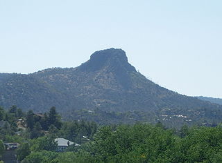
The Sierra Prieta is a 14 miles (23 km) long mountain range in central-northwest Arizona. The range is the mountainous region west of Prescott, with prominent Thumb Butte, 6,514 feet (1,985 m), a volcanic plug, on the city's west perimeter.
Wickenburg Mountains is a mountain range located in Maricopa and Yavapai Counties in Arizona. Denver Hill, at an altitude of 4,406 feet or 1,343 meters, is the tallest peak in the range. 34°02′02″N112°33′59″W
Black Draw is a valley, and tributary stream within the San Bernardino Valley of Cochise County, Arizona. Its waters are a tributary of the San Bernardino River and its mouth lies at an elevation of 3,753 feet / 1,144 meters. Its source is at an elevation of 4,740 feet, at 31°34′17″N109°10′12″W on the northwest slope of Paramore Crater in the upper San Bernardino Valley.
Steamboat Slough is an alternate branch of the Sacramento River, named for its popular use by steamboats traveling between San Francisco and Sacramento. Its mouth is found at an elevation of 3 feet (0.9 m), 2 miles (3 km) above Rio Vista, between Grand Island and Ryer Island. Its head is 11 miles (18 km) above where it leaves the Sacramento River, between Sutter Island and Grand Island, at an elevation of 26 feet (8 m) at 38°18′17″N121°34′25″W.

Waterman Wash is a tributary stream or arroyo of the Gila River, in Maricopa County, Arizona, United States. Its mouth is at its confluence with the Gila River in the Buckeye Valley at an elevation of 843 feet / 257 meters. Its source is at 33°07′11″N112°13′10″W at an elevation of 2,400 feet (730 m) on Sevenmile Mountain. Waterman Wash takes in its tributary West Prong Waterman Wash at 33°10′34″N112°22′00″W.
Buckeye Valley is a valley on the north side of the great bend in the Gila River, in Maricopa County, Arizona. Its mouth is at an elevation of 853 feet / 260 meters. Its head is at an elevation of 922 feet at 33°23′58″N112°21′25″W.

Aztec Pass is a gap and a valley between the Juniper Mountains and Santa Maria Mountains in Yavapai County, Arizona, United States. The summit of the pass is at an elevation of 6,232 feet, at 34°56′12″N112°58′12″W the divide between Muddy Wash on the west and Walnut Creek on the east. The eastern entrance to the pass is at the mouth of the valley of Walnut Creek where it emerges from the hills on the west side of Chino Valley at 34°58′54″N112°38′04″W at an elevation of 4,583 feet / 1,397 meters. The western entrance to the pass is at the top of the valley of Muddy Wash at the foot of the Juniper Mountains, located at 34°58′30″N113°02′03″W.
References
| Authority control: National |
|---|
Coordinates: 34°54′17″N112°33′30″W / 34.90472°N 112.55833°W
| | This Yavapai County, Arizona location article is a stub. You can help Wikipedia by expanding it. |