
Barbury Castle is a scheduled hillfort in Wiltshire, England. It is one of several such forts found along the ancient Ridgeway route. The site, which lies within the Wessex Downs Area of Outstanding Natural Beauty, has been managed as a country park by Swindon Borough Council since 1971. It is situated on Barbury Hill, a local vantage point, which, under ideal weather conditions, commands a view across to the Cotswolds and the River Severn. It has two deep defensive ditches and ramparts. The Old Ridgeway runs close by and the modern Ridgeway crosses through the castle. In the surrounding area are to be found round barrows, Celtic field systems and 18th-19th century flint workings.

Wincanton is a small town and electoral ward in South Somerset, southwest England. The town lies off the A303 road, a main route between London and South West England, and has some light industry. The town and electoral ward has a population of 5,272.

The Blackdown Hills are a range of hills along the Somerset-Devon border in south-western England, which were designated an Area of Outstanding Natural Beauty (AONB) in 1991.
Babcary is a village and civil parish in Somerset, England, about 5 miles (8.0 km) east of Somerton and 6 miles (9.7 km) southwest of Castle Cary, in the South Somerset district. The village has a population of 248. It lies close to the River Cary and the A37. The parish includes the hamlet of Foddington.
Stonehenge, Avebury and Associated Sites is a UNESCO World Heritage Site (WHS) in Wiltshire, England. The WHS covers two large areas of land separated by about 15 miles (24 km), rather than a specific monument or building. The sites were inscribed as co-listings in 1986. Some large and well known monuments within the WHS are listed below, but the area also has an exceptionally high density of small-scale archaeological sites, particularly from the prehistoric period. More than 700 individual archaeological features have been identified. There are 160 separate Scheduled Monuments, covering 415 items or features.

Marlborough Castle, locally known and recorded in historical documents as The Mound, was an 11th-century royal castle located in the civil parish of Marlborough, a market town in the English county of Wiltshire, on the Old Bath Road, the old main road from London to Bath. The barrow on which the fortification was built, perhaps the "barrow of Maerla", seems to be a prehistoric earthwork which formed the motte of the Norman Marlborough Castle. It survives as a tree-covered mound known as Marlborough Mound, within the site of Marlborough College.

Montacute Castle was a castle built on a hill overlooking the village of Montacute, Somerset, England.
Down End Castle, also known as Downend Castle, Chisley Mount or Chidley Mount, was a motte-and-bailey castle at Down End, north of Dunball in the parish of Puriton, Somerset, England. It has been designated as a Scheduled Ancient Monument.

The Yeovil Scarplands are a natural region in southern England in the counties of Somerset and Dorset.

Sand Point in Somerset, England, is the peninsula stretching out from Middle Hope, an 84.1-hectare (208-acre) biological and geological Site of Special Scientific Interest. It lies to the north of the village of Kewstoke, and the stretch of coastline called Sand Bay north of the town of Weston-super-Mare. On a clear day it commands views over Flat Holm, of the Bristol Channel, South Wales, Clevedon, the Second Severn Crossing and the Severn Bridge. A line drawn between Sand Point and Lavernock Point in South Wales marks the lower limit of the Severn Estuary and the start of the Bristol Channel.

Bath and North East Somerset is a unitary authority created on 1 April 1996, following the abolition of the County of Avon, which had existed since 1974. Part of the ceremonial county of Somerset, Bath and North East Somerset occupies an area of 220 square miles (570 km2), two-thirds of which is green belt. It stretches from the outskirts of Bristol, south into the Mendip Hills and east to the southern Cotswold Hills and Wiltshire border. The city of Bath is the principal settlement in the district, but BANES also covers Keynsham, Midsomer Norton, Radstock and the Chew Valley. The area has a population of 170,000, about half of whom live in Bath, making it 12 times more densely populated than the rest of the area.

Taunton Deane was a local government district with borough status in Somerset, England. It merged with West Somerset to form Somerset West and Taunton on 1 April 2019. Its council was based in Taunton. The district was formed on 1 April 1974, under the Local Government Act 1972, by a merger of the Municipal Borough of Taunton, Wellington Urban District, Taunton Rural District, and Wellington Rural District. Taunton Deane was granted borough status in 1975, enabling the mayoralty of Taunton to be continued, when other districts did not have mayors. The district was given the name of an alternate form of the Taunton Deane Hundred.

West Somerset was a local government district in the English county of Somerset. It merged with Taunton Deane to form Somerset West and Taunton on 1 April 2019. The council covered a largely rural area, with a population of 35,075 in an area of 740 square kilometres (290 sq mi). According to figures released by the Office for National Statistics in 2009, the population of West Somerset had the oldest average age in the United Kingdom at 52. The largest centres of population were the coastal towns of Minehead and Watchet (4,400).

There are over 670 scheduled monuments in the ceremonial county of Somerset in South West England. The county consists of a non-metropolitan county, administered by Somerset County Council, which is divided into five districts, and two unitary authorities. The districts of Somerset are West Somerset, South Somerset, Taunton Deane, Mendip and Sedgemoor. The two administratively independent unitary authorities, which were established on 1 April 1996 following the breakup of the county of Avon, are North Somerset and Bath and North East Somerset. These unitary authorities include areas that were once part of Somerset before the creation of Avon in 1974.
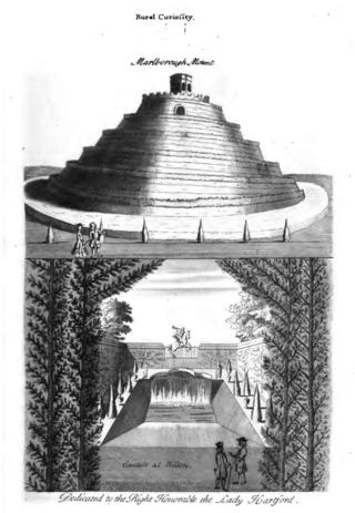
Marlborough Mound is a Neolithic monument in the town of Marlborough in the English county of Wiltshire. Standing 19 metres tall, it is second only to the nearby Silbury Hill in terms of height for such a monument. Modern study situates the construction date around 2400 BC. It was first listed as a Scheduled Monument in 1951.
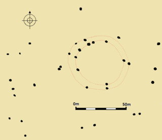
Fir Clump Stone Circle was a stone circle in Burderop Wood near Wroughton, Wiltshire, in South West England. The ring was part of a tradition of stone circle construction that spread throughout much of Britain, Ireland, and Brittany during the Late Neolithic and Early Bronze Age, over a period between 3300 and 900 BCE. The purpose of such monuments is unknown, although some archaeologists speculate that the stones represented supernatural entities for the circle's builders.

