
Apache County is a county in the northeast corner of the U.S. state of Arizona. Shaped in a long rectangle running north to south, as of the 2020 census, its population was 66,021. The county seat is St. Johns.
Fort Defiance is a census-designated place (CDP) in Apache County, Arizona, United States. It is also located within the Navajo Nation. The population was 3,624 at the 2010 census.

Sawmill is a census-designated place (CDP) in Apache County, Arizona, United States. Sawmill is a part of Fort Defiance Agency, which is on the Navajo Nation. The population was 748 at the 2010 census. It is named after and developed around a sawmill. A trading post has been present since 1907.

St. Michaels is a chapter of the Navajo Nation and a census-designated place (CDP) in Apache County, Arizona, United States. The Navajo Nation Government Campus is located within the chapter at Window Rock.

Window Rock, known in Navajo as Tségháhoodzání, is a city and census-designated place that serves as the capital of the Navajo Nation, the largest Native American tribe by both land and tribal enrollment. The capital lies within the boundaries of the St. Michaels Chapter, adjacent to the Arizona and New Mexico state line. Window Rock is the site of the Navajo Nation governmental campus, which contains the Navajo Nation Council, Navajo Nation Supreme Court, the offices of the Navajo Nation President and Vice President, and many Navajo government buildings.

Diné College is a public tribal land-grant college based in Tsaile, Arizona, serving the 27,000-square-mile (70,000 km2) Navajo Nation. It offers associate degrees, bachelor's degrees, and academic certificates.

Northern Arizona is an unofficial, colloquially defined region of the U.S. state of Arizona. Generally consisting of Apache, Coconino, Mohave, Navajo, and Yavapai counties, the region is geographically dominated by the Colorado Plateau, the southern border of which in Arizona is called the Mogollon Rim.

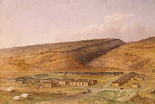
Fort Wingate was a military installation near Gallup, New Mexico, United States. There were two other locations in New Mexico called Fort Wingate: Seboyeta, New Mexico (1849–1862) and San Rafael, New Mexico (1862–1868). The most recent Fort Wingate (1868–1993) was established at the former site of Fort Lyon, on Navajo territory, initially to control and "protect" the large Navajo tribe to its north. The Fort at San Rafael was the staging point for the Navajo deportation known as the Long Walk of the Navajo. From 1870 onward the garrison near Gallup was concerned with Apaches to the south, and through 1890 hundreds of Navajo Scouts were enlisted at the fort.

Chinle High School is a public high school in Chinle, an unincorporated area of Apache County, Arizona, United States. The school is the only high school in the Chinle Unified School District, and all of the district's elementary and middle schools feed into it. Chinle High School serves several unincorporated areas in Apache County, including Chinle, Cottonwood, Del Muerto, Lukachukai, Many Farms, Nazlini, Rough Rock, Sehili, Tsaile, and small portions of Round Rock and Sawmill. The areas the school serves are within the Navajo Nation.
Chinle Unified School District No. 24 (CUSD) is a public unified school district headquartered in Chinle, a census-designated place in Apache County, Arizona, on the Navajo Nation, United States. It is managed by a five-member elected school board, each of whom is Navajo, and operates by state rules. As of 2020, nearly all of the district's 3600 students are Navajo.
Window Rock Unified School District (WRUSD) is a school district within Apache County, Arizona, United States. The district comprises seven schools within a 65-mile radius.
Rezball, short for "reservation ball," is a style of basketball associated with Native Americans, particularly at the high school level in the Southwestern United States, where many of the Indian reservations were created in the country.
Red Rock is an unincorporated community and census-designated place (CDP) in Apache County, Arizona, United States. Red Rock is located on the Navajo Nation near the New Mexico border, 16 miles (26 km) northeast of Lukachukai. Red Rock has a post office with ZIP code 86544; the post office uses the Red Valley name. As of the 2010 census, the Red Rock CDP had a population of 169.
Ganado High School is a high school in Ganado, Arizona. It is the only high school under the jurisdiction of the Ganado Unified School District.
Red Mesa High School is a high school in Red Mesa in an unincorporated area of Apache County, Arizona, near Teec Nos Pos. It is one of two high schools under the jurisdiction of the Red Mesa Unified School District, along with Red Valley/Cove High School.

Black Creek of Arizona is a 55-mi (89 km) long north tributary of the Puerco River, in northeast Arizona and northwest New Mexico.

Oak Springs is a census-designated place (CDP) in Apache County, Arizona, United States. The population was 63 at the 2010 census.

The Wood Springs 2 Fire was a wildfire in the Navajo Nation, 3 miles (4.8 km) east of Wood Springs in Apache County, Arizona in the United States. The result of a lightning strike, the fire was first reported on June 27, 2020. The fire burned a total of 12,861 acres (5,205 ha) and was 98 percent contained as of July 13, 2020. Two outbuildings and five livestock pens were destroyed. One residence was damaged. The fire threatened the area around Fluted Rock, Arizona.
Hunters Point Boarding School, Inc. is a boarding elementary school, operated by the Navajo tribe, in unincorporated Apache County, Arizona, with a St Michaels address. It is operated in partnership with the Bureau of Indian Education (BIE). A school board manages the school, which is funded with money from the federal government.
