
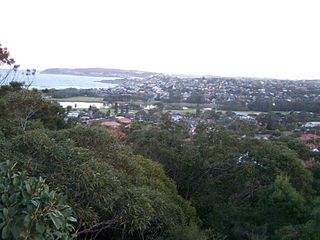
The Northern Beaches is an area in the northern coastal suburbs of Sydney, in the state of New South Wales, Australia, near the Pacific coast. This area extends south to the entrance of Port Jackson, west to Middle Harbour and north to the entrance of Broken Bay. The area was formerly inhabited by the Garigal or Caregal people in a region known as Guringai country.

Warringah Council was a local government area in the northern beaches region of Sydney, in the state of New South Wales, Australia. It was proclaimed on 7 March 1906 as the Warringah Shire Council, and became "Warringah Council" in 1993. In 1992, Pittwater Council was formed when the former A Riding of Warringah Shire voted to secede. From this point on until amalgamation, Warringah Council administered 152 square kilometres (59 sq mi) of land, including nine beaches and 14 kilometres (9 mi) of coastline. Prior to its abolition it contained 6,000 hectares of natural bushland and open space, with Narrabeen Lagoon marking Warringah's northern boundary and Manly Lagoon marking the southern boundary.

Wynyard railway station is a heritage-listed underground commuter rail station located in the north-west precinct of the Sydney central business district, in New South Wales, Australia. The station opened on 28 February 1932 to coincide with the opening of the Sydney Harbour Bridge.

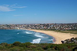
Narrabeen is a beachside suburb in northern Sydney, in the state of New South Wales, Australia. Narrabeen is 23 kilometres north-east of the Sydney central business district, in the local government area of Northern Beaches Council and is part of the Northern Beaches region. This area was named Broken Bay by James Cook as he sailed by.

Copacabana is a suburb located on the Central Coast of New South Wales, Australia, as part of the Central Coast Council local government area. Copacabana is situated at the northern end of Macmasters Beach, the two beaches divided by Cochrone Lagoon. The northern headland of Copacabana beach is Tudibaring Point, purported to mean 'place where the waves pound like a beating heart' in the local indigenous language. The bay itself is Allagai, which means "nest of snakes" in the same language.

Dee Why is a coastal suburb of northern Sydney, in the state of New South Wales, Australia, 18 kilometres north-east of the Sydney central business district. It is the administrative centre of the local government area of Northern Beaches Council and, along with Brookvale, is considered to be the main centre of the Northern Beaches region.
Elanora Heights is a suburb in northern Sydney, in the state of New South Wales, Australia. Elanora Heights is 27 kilometres north-east of the Sydney central business district, in the local government area of Northern Beaches Council. Elanora Heights is part of the Northern Beaches region.

The Division of Mackellar is an Australian electoral division in the state of New South Wales.

The Division of Warringah is an Australian electoral division in the state of New South Wales.

Queenscliff is a suburb of northern Sydney, in the state of New South Wales, Australia. Queenscliff is located 16 kilometres north-east of the Sydney central business district, in the local government area of Northern Beaches Council and is part of the Northern Beaches region.

North Narrabeen is a suburb in northern Sydney, New South Wales, Australia 25 kilometres north of the Sydney central business district, in the local government area of Northern Beaches Council. North Narrabeen is part of the Northern Beaches region.
North Curl Curl is a suburb in northern Sydney, in the state of New South Wales, Australia 19 kilometres north-east of the Sydney central business district, in the local government area of Northern Beaches Council. It is part of the Northern Beaches region.
Curl Curl is a suburb of northern Sydney in the state of New South Wales, Australia, 18 kilometres (11 mi) north-east of the Sydney central business district, in the local government area of Northern Beaches Council. It is part of the Northern Beaches region.

Brookvale is a suburb of northern Sydney, in the state of New South Wales, Australia. Brookvale is 16 kilometres north-east of the Sydney central business district, in the local government area of Northern Beaches Council. It is part of the Northern Beaches region.
Cromer is a suburb of northern Sydney, in the state of New South Wales, Australia. Cromer is 20 kilometres north-east of the Sydney central business district, in the local government area of Northern Beaches Council and is part of the Northern Beaches region. Cromer is bordered to the north by Narrabeen Lakes.

The two Dee Why class ferries, Dee Why and Curl Curl, were two identical steam ferries servicing Sydney Harbour's Circular Quay to Manly service. Both commissioned in 1928, the Curl Curl served until 1960 while Dee Why was in service until 1968. Until the introduction of the South Steyne in 1938, they were the largest and fastest ferries on Sydney Harbour.
The State Parks of New South Wales are eighteen protected areas in New South Wales, Australia reserved for camping, water sports and recreational uses. State Parks are maintained by the New South Wales Department of Lands and managed by community trust boards.

Freshwater is a suburb of northern Sydney, in the state of New South Wales, Australia. Freshwater is located 17 kilometres (11 mi) north-east of the Sydney central business district, in the local government area of Northern Beaches Council and is part of the Northern Beaches region.

HMAS Doomba was a Royal Australian Navy (RAN) warship of World War II. Built for the Royal Navy around the end of World War I as the Hunt-class minesweeper HMS Wexford, the ship only saw two years of service before she was decommissioned in 1921 and sold to the Doomba Shipping Company. The vessel was renamed SS Doomba, converted into a passenger ship, and operated in the waters around Brisbane until 1939, when she was requisitioned by the RAN for wartime service. Serving first as an auxiliary minehunter, then an auxiliary anti-submarine vessel, HMAS Doomba was purchased outright by the RAN in 1940, and served until early 1946, when she was sold and converted into a linseed oil lighter. Doomba was scuttled off Dee Why, New South Wales in 1976.

The Northern Beaches Council is a local government area located in the Northern Beaches region of Sydney, in the state of New South Wales, Australia. The Council was formed on 12 May 2016 after the amalgamation of Manly, Pittwater and Warringah Councils.