Cottage Point, New South Wales

Last updated

Cottage Point
Sydney,  New South Wales
Cottage Point Inn.jpg
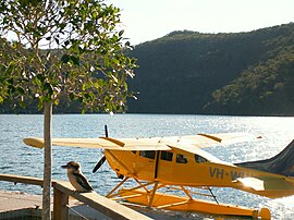
A waterplane lands next to the Cottage Point Inn
Population 98 (2016 census) [1]
Postcode(s) 2084
Location 38 km (24 mi) north of Sydney CBD
LGA(s) Northern Beaches Council
State electorate(s) Pittwater
Federal Division(s) Mackellar
Suburbs around Cottage Point:
Brooklyn Brooklyn Coasters Retreat
Berowra Cottage Point Morning Bay
Mount Kuring-gai Ku-ring-gai Chase National Park Akuna Bay


Cottage Point is a suburb of northern Sydney, in the state of New South Wales, Australia. Cottage Point is 38 kilometres north of the Sydney central business district, in the local government area of Northern Beaches Council.

Suburb Human settlement that is part of or near to a larger city

A suburb is a mixed-use or residential area, existing either as part of a city or urban area or as a separate residential community within commuting distance of a city. In most English-speaking countries, suburban areas are defined in contrast to central or inner-city areas, but in Australian English and South African English, suburb has become largely synonymous with what is called a "neighborhood" in other countries and the term extends to inner-city areas. In some areas, such as Australia, India, China, New Zealand, the United Kingdom, and a few U.S. states, new suburbs are routinely annexed by adjacent cities. In others, such as Saudi Arabia, Canada, France, and much of the United States, many suburbs remain separate municipalities or are governed as part of a larger local government area such as a county.

Sydney City in New South Wales, Australia

Sydney is the state capital of New South Wales and the most populous city in Australia and Oceania. Located on Australia's east coast, the metropolis surrounds Port Jackson and extends about 70 km (43.5 mi) on its periphery towards the Blue Mountains to the west, Hawkesbury to the north, the Royal National Park to the south and Macarthur to the south-west. Sydney is made up of 658 suburbs, 40 local government areas and 15 contiguous regions. Residents of the city are known as "Sydneysiders". As of June 2017, Sydney's estimated metropolitan population was 5,131,326, and is home to approximately 65% of the state's population.

New South Wales State of Australia

New South Wales is a state on the east coast of Australia. It borders Queensland to the north, Victoria to the south, and South Australia to the west. Its coast borders the Tasman Sea to the east. The Australian Capital Territory is an enclave within the state. New South Wales' state capital is Sydney, which is also Australia's most populous city. In March 2018, the population of New South Wales was over 7.9 million, making it Australia's most populous state. Just under two-thirds of the state's population, 5.1 million, live in the Greater Sydney area. Inhabitants of New South Wales are referred to as New South Welshmen.

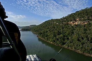
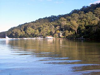
Cottage Point is located in the Ku-ring-gai Chase National Park at the confluence of Cowan Creek and Coal and Candle Creek. It is accessible by Cottage Point Road off Liberator General San Martin Drive. [2]

Ku-ring-gai Chase National Park Protected area in New South Wales, Australia

The Ku-ring-gai Chase National Park is a protected national park that is located in New South Wales, Australia. The 14,977-hectare (37,010-acre) national park is situated 25 kilometres (16 mi) north of Sydney located largely within the Ku-ring-gai, Hornsby, and the Northern Beaches Council local government areas. The villages of Cottage Point, Appletree Bay, and Bobbin Head are located within park boundaries. An isolated portion of the park, Barrenjoey Headland, is located to the north of Palm Beach east of the primary park body and is home to Barrenjoey Lighthouse.

Cowan Creek river in Australia

Cowan Creek is located in New South Wales, Australia. It is a tidal subcatchment of the Hawkesbury River. Almost all of the catchment lies within Ku-ring-gai Chase National Park. Tributaries include Coal and Candle Creek, which branches off from Cowan Creek at Cottage Point and Smiths Creek.

Coal and Candle Creek river in New South Wales, Australia

Coal and Candle Creek is a creek located in Sydney, Australia. It is a tributary of Cowan Creek which flows into the Hawkesbury River.

Related Research Articles

Sydney Cove Bay in Sydney Harbour, Australia

Sydney Cove is a small bay on the southern shore of Sydney Harbour, one of several harbours in Port Jackson, on the coast of Sydney, New South Wales, Australia. It is one of Australia's leading tourist sites.

Dundas is a suburb of the Northern Suburbs District in Sydney, New South Wales, Australia. Dundas is located 21 kilometres north-west of the Sydney central business district, in the local government area of the City of Parramatta and the electoral division of Bennelong. Dundas is a leafy green suburb, notably due to its centrepiece The Ponds Walk, which follows the Ponds Subiaco Creek.

Akuna Bay, New South Wales New South Wales, Australia

Akuna Bay is an urban place in Sydney, Australia. Akuna Bay is located 38 kilometres (24 mi) north of the Sydney central business district, in the local government area of Northern Beaches Council.

Division of Mackellar Australian federal electoral division

The Division of Mackellar is an Australian electoral division in the state of New South Wales. The division is named after Sir Charles Mackellar, a social reformer and surgeon who served in the Senate from October to November 1903, and his daughter Dorothea Mackellar, a 20th-century Australian poet. The division was proclaimed at the redistribution of 11 May 1949, and was first contested at the 1949 federal election.

Salt Pan Creek, an urban watercourse of the Georges River catchment, is located in the Canterbury-Bankstown region of Sydney, in New South Wales, Australia.

Huntleys Point, New South Wales Suburb of Sydney, New South Wales, Australia

Huntleys Point is a suburb on the Lower North Shore of Sydney, in the state of New South Wales, Australia. Huntleys Point is located 9 kilometres north-west of the Sydney central business district, in the local government area of the Municipality of Hunter's Hill. Huntleys Point sits on the northern shore of the Parramatta River.

Berowra Creek river in New South Wales, Australia

The Berowra Creek, a watercourse that is part of the Hawkesbury-Nepean catchment, is located to the north of the Sydney central business district in the Hornsby Shire of New South Wales, Australia.

Cheero Point, New South Wales Suburb of Central Coast, New South Wales, Australia

Cheero Point is a residential suburb of the Central Coast region of New South Wales, Australia, located on the west bank of the Mooney Mooney Creek 49 kilometres (30 mi) north of Sydney. It is part of the Central Coast Council local government area.

Mooney Mooney Creek, New South Wales Suburb of Central Coast, New South Wales, Australia

Mooney Mooney Creek is a suburb of the Central Coast region of New South Wales, Australia, located 60 kilometres (37 mi) north of Sydney along both sides of the river after which it is named. It is part of the Central Coast Council local government area.

Huntleys Cove, New South Wales Suburb of Sydney, New South Wales, Australia

Huntleys Cove is a suburb in the Northern Suburbs of Sydney, in the state of New South Wales, Australia. Huntleys Cove is located 9 kilometres north-west of the Sydney central business district, in the local government area of the Municipality of Hunter's Hill. Huntleys Cove sits on the peninsula between Tarban Creek and the Parramatta River.

Morning Bay, New South Wales Suburb of Sydney, New South Wales, Australia

Morning Bay is a suburb and adjoining bay in northern Sydney, in the state of New South Wales, Australia. Morning Bay is located 40 kilometres north of the Sydney central business district, in the local government area of Northern Beaches Council.

Elvina Bay, New South Wales Suburb of Sydney, New South Wales, Australia

Elvina Bay is a bay and adjacent suburb in northern Sydney, in the state of New South Wales, Australia. It is located 35 kilometres north of the Sydney central business district, in the local government area of Northern Beaches Council.

Lovett Bay, New South Wales Suburb of Sydney, New South Wales, Australia

Lovett Bay is a suburb and adjacent bay in northern Sydney, in the state of New South Wales, Australia. It is 36 kilometres north of the Sydney central business district, in the local government area of Northern Beaches Council.

Coxs Creek, a watercourse of the Cooks River catchment, is located in the Inner West of Sydney, in New South Wales, Australia.

Bare Creek river in Australia

Bare Creek, a watercourse that is part of the Middle Harbour catchment of Sydney Harbour, is located in the northern beaches region of Sydney, New South Wales, Australia.

Bilgola Creek is an urban gully or open channel that is located in the northern beaches region of Sydney, New South Wales, Australia.

Boggywell Creek, an urban gully that is part of the Georges River catchment, is located in the southern Sydney district of St George, in New South Wales, Australia.

Devlins Creek river in Australia

Devlins Creek, an urban watercourse that is part of the Parramatta River catchment, is located in Northern Suburbs region of Sydney, Australia.

Gore Creek, an urban watercourse that is part of the Parramatta River catchment, is located in Northern Suburbs region of Sydney, Australia.

References

  1. Australian Bureau of Statistics (27 June 2017). "Cottage Point". 2016 Census QuickStats. Retrieved 17 August 2018. Blue pencil.svg
  2. "Cottage Point". Geographical Names Register (GNR) of NSW. Geographical Names Board of New South Wales.

Coordinates: 33°37′15″S151°12′08″E / 33.62091°S 151.20225°E / -33.62091; 151.20225

Geographic coordinate system Coordinate system

A geographic coordinate system is a coordinate system that enables every location on Earth to be specified by a set of numbers, letters or symbols. The coordinates are often chosen such that one of the numbers represents a vertical position and two or three of the numbers represent a horizontal position; alternatively, a geographic position may be expressed in a combined three-dimensional Cartesian vector. A common choice of coordinates is latitude, longitude and elevation. To specify a location on a plane requires a map projection.