Great Mackerel Beach, New South Wales

Last updated

Great Mackerel Beach
Sydney,  New South Wales
Great Mackerel Beach from southern headland.jpg
Great Mackerel Beach, photographed from the south
Great Mackerel Beach, New South Wales
Great Mackerel Beach
Population36 (2016 census) [1]
Postcode(s) 2108
Location43 km (27 mi) north of Sydney CBD
LGA(s) Northern Beaches Council
State electorate(s) Pittwater
Federal Division(s) Mackellar
Suburbs around Great Mackerel Beach:
Ku-ring-gai Chase National Park Great Mackerel Beach Palm Beach
Currawong Beach

Great Mackerel Beach is a suburb about 43 kilometres north of the Sydney central business district, from 2016 in the local government area of Northern Beaches Council, Sydney, New South Wales, Australia, [2] formerly part of Pittwater Council. It is on the western shores of Pittwater in Ku-ring-gai Chase National Park, beside Currawong Beach, and near Coasters Retreat and Palm Beach. The population was 36 at the 2016 census; the median age was 66, with an average of 0.3 children per family and an average of 2 people per household. [1] The population was 301 at the 2011 census, [3] and 103 in 2006. [4] Currently[ when? ] there are 55 permanent residents in 27 properties, with many additional residents occupying properties throughout school holidays and weekends.

Contents

Great Mackerel Beach is frequently referred to as Mackerel Beach or [Great] Mackeral Beach, although the spelling "Mackerel" is becoming standard. [4] [3]

Nearby Currawong Beach is sometimes called Little Mackerel Beach. [5]

Geography

The Mackerel valley was formed by a creek that flows from within the National Park, passing through sub-tropical rain forest and mangroves to exit at the north end of the beach where a sand delta has been formed. The sand on the beach is the result of sandstone flowing down the Hawkesbury River and is soft and golden.

History

Mackerel was originally a dairy farm settled in 1823 by a John Clark who sold it on to Martin Burke who is known as "The Father of Pittwater". Subdivision of Mackerel took place in 1920 and since then over 100 houses have been built. Originally most of the houses were fibro shacks built as fishermen’s cottages and weekenders. However much development has occurred since and now Mackerel has a large variety of homes ranging from some of the original shacks to waterfront mansions.

Housing

At the 2016 census there were 105 dwellings. [1] of which none were apartments, with an average of 2.2 people per occupied dwelling. [3] There are no shops.

Mackerel Beach is largely considered a "holiday home haven", [6] [7] but it is increasingly seen as a beachside suburb, although access to central Sydney CBD requires a boat (private, ferry, water taxi) followed by a 43km road journey.

Median property price fluctuates (statistically, due to the small number of properties), but was around A$550,000 in 2013, significantly higher than the figure for all of NSW. [8]

Facilities

The Northern Beaches Council says "there are no public facilities at Mackerel Beach". [9] Electricity and telephone (and hence Internet) connection are available, but there is no water supply and no sewerage - houses have water tanks to collect rainwater for all purposes, and septic tanks. Residents' rubbish is collected twice weekly from containers at the wharf.

Transport

Great Mackerel Beach has no road access and no roads or vehicles; [10] access is by the Palm Beach Ferry, [11] water taxi, or private boat. Access to Sydney is normally by a short boat (private or ferry) trip to Palm Beach, then a 43km journey by car or bus. Cars may be left parked near the ferry terminal at Palm Beach.

Public facilities

There are no public facilities for use by visitors or residents at Great Mackerel Beach, including shops, toilets, barbecue or picnic facilities, or availability of drinking water. There is a public telephone booth near the wharf. Residents' rubbish is collected twice weekly, but there is no public facility. Limited shopping facilities are available via a short boat ride to Palm Beach, and there are more comprehensive shops in the surrounding area.

Recreational boating

While many residents have boats, there are no moorings available for visiting recreational boating at Great Mackerel Beach, including no Commercial/Club (orange) or Courtesy (pink) moorings. Visiting recreational boats may not tie-up on Great Mackerel Beach Wharf. [12] Private (yellow) moorings may not be used by non-owners and may not be sublet or traded in any way. [13]

Community

MBA

The Mackerel Beach Association [14] is a group of about sixty five property-owners who represent the wider community (especially with Council) on issues such as parking, garbage collection and other issues of import to the community.

Pet animals

Due to its position bordering the Ku-ring-gai National Park, pet dogs have historically been prohibited from Mackerel Beach, as they are at The Basin and Currawong and other communities positioned along the western foreshores of Pittwater. Mackerel Beach is a Wildlife Protection Area (WPA); a major concern is protection of indigenous wildlife. [15]

In 2007 some residents asked the MBA for a leash-free area on the south end of the beach. This was rejected by the MBA at the AGM; the residents then raised the request with Pittwater Council, which decided to run a six-month trial of a Public Dog Exercise Area (PDEA) at the north end of the beach. Many residents disagreed with this decision. The area defined by the PDEA prohibited dogs from being walked past the northernmost house, as this region constitutes part of Ku-ring-gai Chase National Park, home to many native mammals, reptiles and bird species.

In 2008 the National Parks and Wildlife Service submitted a report to Pittwater Council that advised against a PDEA at Mackerel Beach.

In December 2009 Pittwater Council resolved to permanently allow dogs off leads at Mackerel Beach between the public wharf north to the last house/National Park boundary, at certain times and with restrictions. [16] The regulations are difficult to enforce in sparsely-populated and isolated Mackerel Beach. A man was injured by an attack from a dog on a leash in 2012. [17]

Cats are prohibited in WPAs; [15] Pittwater Council banned pet cats from Mackerel Beach due to their impact on the native wildlife.

Related Research Articles

Garigal National Park Protected area in New South Wales, Australia

The Garigal National Park is a protected national park that is located within the North Shore and Forest District regions of Sydney, New South Wales, in eastern Australia. The 2,202-hectare (5,440-acre) national park is situated approximately 20 kilometres (12 mi) north of the Sydney central business district.

Ku-ring-gai Chase National Park Protected area in New South Wales, Australia

Ku-ring-gai Chase National Park is a national park on the northern side of Sydney in New South Wales, Australia. The 14,977-hectare (37,010-acre) park is 25 kilometres (16 mi) north of the Sydney Central Business District and generally comprises the land east of the M1 Pacific Motorway, south of the Hawkesbury River, west of Pittwater and north of Mona Vale Road. It includes Barrenjoey Headland on the eastern side of Pittwater.

Palm Beach, New South Wales Suburb of Sydney, New South Wales, Australia

Palm Beach is a suburb in the Northern Beaches region of Sydney, in the state of New South Wales, Australia. Palm Beach is located 41 kilometres (25 mi) north of the Sydney central business district, in the local government area of Northern Beaches Council. Palm Beach sits on a peninsula at the end of Barrenjoey Road, between Pittwater and Broken Bay. The population of Palm Beach was 1,593 as at the 2016 census.

Northern Beaches Region in New South Wales, Australia

The Northern Beaches is a region within Northern Sydney, in the state of New South Wales, Australia, near the Pacific coast. This area extends south to the entrance of Port Jackson, west to Middle Harbour and north to the entrance of Broken Bay. The area was formerly inhabited by the Garigal or Caregal people in a region known as Guringai country.

Pittwater Council Local government area in New South Wales, Australia

Pittwater Council was a local government area on the Northern Beaches of Sydney, in the state of New South Wales, Australia. It covered a region adjacent to the Tasman Sea about 30 kilometres (19 mi) north of the Sydney central business district. The area is named after Pittwater, the body of water adjacent to much of the area governed. First proclaimed in 1906 as the A Riding of Warringah Shire, the area was proclaimed as the Municipality of Pittwater on 1 May 1992. On 12 May 2016, the Minister for Local Government announced that Pittwater Council would be subsumed into the newly formed Northern Beaches Council. The last Mayor of Pittwater Council was Councillor Jacqui Townsend, an independent politician.

Brooklyn, New South Wales Town in New South Wales, Australia

Brooklyn is a town in the state of New South Wales, Australia, in the local government area of Hornsby Shire with a population of 722 as of the 2016 census. Brooklyn is surrounded by the Muogamarra Nature Reserve and occupies a strip of waterfront along the southern bank of the Hawkesbury River.

Elanora Heights is a suburb in northern Sydney, in the state of New South Wales, Australia. Elanora Heights is 27 kilometres north-east of the Sydney central business district, in the local government area of Northern Beaches Council. Elanora Heights is part of the Northern Beaches region.

Pittwater

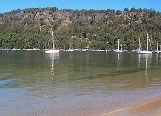
Pittwater is a semi-mature tide dominated drowned valley estuary, located about 40 kilometres (25 mi) north of the Sydney central business district, New South Wales, Australia; being one of the bodies of water that separate greater Metropolitan Sydney from the Central Coast.

Scotland Island, New South Wales Island suburb of Sydney, Australia

Scotland Island is an island and suburb on the Northern Beaches of Sydney, in the state of New South Wales, Australia. Church Point, Scotland Island's major mainland service locality, is located 32 kilometres north of the Sydney central business district, in the local government area of Northern Beaches Council.

Church Point, New South Wales Suburb of Sydney, New South Wales, Australia

Church Point is a suburb in the Northern Beaches region of Sydney, in the state of New South Wales, Australia. Church Point is 32 kilometres north of the Sydney central business district, in the local government area of Northern Beaches Council.

Coasters Retreat, New South Wales New South Wales, Australia

Coasters Retreat is an offshore suburb in northern Sydney, in the state of New South Wales, Australia, 42 kilometres north of the Sydney central business district, in the local government area of Northern Beaches Council.

Currawong Beach Suburb of Sydney, New South Wales, Australia

Currawong Beach is a suburb in northern Sydney, in the state of New South Wales, Australia. Currawong Beach is 42 kilometres (26 mi) north of the Sydney central business district, in the local government area of Northern Beaches Council.

Dodges Ferry Town in Tasmania, Australia

Dodges Ferry is a town in the local government area of Sorell, Tasmania, Australia located 38 km (23.5 mi) east of the town of Hobart.

Elvina Bay, New South Wales Suburb of Sydney, New South Wales, Australia

Elvina Bay is a bay and adjacent suburb in northern Sydney, in the state of New South Wales, Australia. It is located 35 kilometres north of the Sydney central business district, in the local government area of Northern Beaches Council.

Lovett Bay, New South Wales Suburb of Sydney, New South Wales, Australia

Lovett Bay is a suburb and adjacent bay in northern Sydney, in the state of New South Wales, Australia. It is 36 kilometres north of the Sydney central business district, in the local government area of Northern Beaches Council.

The Basin, New South Wales

The Basin is a locality in northern Sydney, in the Australian state of New South Wales. The Basin is located 42 kilometres north of the Sydney central business district, in the local government area of Pittwater Council.

Port Jackson and Manly Steamship Company

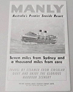
The Port Jackson and Manly Steamship Company (PJ&MSC) was a publicly listed company that operated the Manly ferries in Sydney, Australia. After being taken over by Brambles Industries, the ferry service was eventually taken over by the State Government and is now part of Sydney Ferries.

Barrenjoey Head Lighthouse Lighthouse in New South Wales, Australia

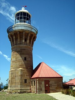
The Barrenjoey Head Lighthouse is a heritage-listed lighthouse at Barrenjoey Headland, Palm Beach, Northern Beaches Council, New South Wales, Australia. It was designed by James Barnet, the New South Wales Colonial Architect and built by Isaac Banks. It is also known as Barrenjoey Head Lightstation. The property is owned by Office of Environment and Heritage, an agency of the Government of New South Wales. The lightstation was added to the New South Wales State Heritage Register on 2 April 1999.

Northern Beaches Council Local government area in New South Wales, Australia

The Northern Beaches Council is a local government area located in the Northern Beaches region of Sydney, in the state of New South Wales, Australia. The Council was formed on 12 May 2016 after the amalgamation of Manly, Pittwater and Warringah Councils.

Currawong Workers Holiday Camp

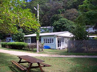
The Currawong Workers' Holiday Camp is a heritage-listed former farm and now workers' holiday camp located at Currawong Beach, Northern Beaches Council, New South Wales, Australia. It was designed by various parties including the Van Dyke Brothers, Hudsen's Homes and built in 1950. The property is also known as Little Mackerel, Labor Council's Holiday Resort, Unions NSW Currawong Holiday Cottages, and Midholme and Coaster's Retreat. The property is Crown land and owned by the Government of New South Wales. The property was added to the New South Wales State Heritage Register on 12 May 2009.

References

  1. 1 2 3 "2016 Census QuickStats: Great Mackerel Beach". Censusdata.abs.gov.au. 27 June 2016. Retrieved 11 July 2017.
  2. "Great Mackerel Beach". Geographical Names Register (GNR) of NSW. Geographical Names Board of New South Wales . Retrieved 31 May 2013. OOjs UI icon edit-ltr-progressive.svg
  3. 1 2 3 "2011 Census QuickStats: Great Mackerel Beach". Censusdata.abs.gov.au. Retrieved 3 June 2017. 2016 census data are available from mid-2017
  4. 1 2 "2006 Census QuickStats: Great Mackeral (sic) Beach". Censusdata.abs.gov.au. Retrieved 3 June 2017.
  5. Mackerel is surrounded on three sides by the Ku-ring-gai Chase National Park, with a beach leading to the water Pittwater. The suburb of Currawong Beach adjoins to the south. T and offers residents a year round holiday lifestyle, isolated from the hustle and bustle of the city, yet only a 10-minute boat ride back to "the mainland". The beach is soft golden sand and is ideal for swimming as the southern end becomes deep quite quickly and the northern end has a lovely large sandbank which gradually protrudes into the water Great Mackerel Beach Reserve. Pittwater Council. Pittwater.nsw.gov.au. Retrieved on 2012-02-01.
  6. Kate Burke (2 December 2016). "Sydneysiders look to remote Great Mackerel Beach for affordable lifestyle". domain.com. Retrieved 4 June 2017.
  7. Kathryn Welling, Manly Daily (8 August 2014). "Sydney waterfront for less than $1million". News.com. Retrieved 4 June 2017. Only 30 of the houses are permanently lived in, the rest are weekenders"
  8. "Great Mackerel Beach House Prices & Property Trends". propertyvalue.com.au. Retrieved 4 June 2017.
  9. "Pittwater-Mackerel Beach". Northern Beaches Council. Retrieved 4 June 2017.
  10. "Google Maps". Google Maps. Retrieved 4 June 2017. Google Maps shows no roads into Mackerel Beach. Mackerel Trail, and the trails in Mackerel Beach, are not suitable for motor vehicles.
  11. "Palm Beach Ferries". Fantasea Cruising. Retrieved 4 June 2017.
  12. "Mooring types". Roads and Maritime Services- New South Wales. Retrieved 3 June 2017. Only approved vessels are able to secure to a private, commercial/club or emergency mooring. Penalties apply for non-compliance.
  13. "Private Moorings". Roads and Maritime Services- New South Wales. Retrieved 3 June 2017.
  14. "Offshore Living - Associations". West Pittwater Community Association. Retrieved 4 June 2017.
  15. 1 2 Pittwater Council: Wildlife Protection Areas and Dogs in Public Areas – Mackerel Beach, 17 December 2007
  16. "Pittwater-Exercise Areas". Northern Beaches Council -. Retrieved 4 June 2017.
  17. "Man loses thumb in dog attack". Manly Daily. 18 January 2012. Archived from the original on 20 March 2012. Comments to this article complain that residents and day-trippers allow dogs off-leash without restriction, and that no action is taken.

Coordinates: 33°35′30″S151°18′3″E / 33.59167°S 151.30083°E / -33.59167; 151.30083