Avalon, New South Wales

Last updated

Avalon Beach
Sydney,  New South Wales
1avalon nsw1.jpg
Avalon Beach, looking north
Population9,905 (2016 census) [1]
Established1921
Postcode(s) 2107
Location37 km (23 mi) north of Sydney CBD
LGA(s) Northern Beaches Council
State electorate(s) Pittwater
Federal Division(s) Mackellar
Suburbs around Avalon Beach:
Careel Bay Palm Beach Whale Beach
Clareville Avalon Beach Tasman Sea
Bilgola Newport Tasman Sea

Avalon Beach is a northern beach side suburb of Sydney, in the state of New South Wales, Australia. It is 37 kilometres north of the Sydney central business district, in the local government area of Northern Beaches Council, in the Northern Beaches region. The area is also known as Avalon, with the name Avalon Beach being assigned during a change in boundaries and names in the Pittwater region in 2012. [2]

Suburb Human settlement that is part of or near to a larger city

A suburb is a mixed-use or residential area, existing either as part of a city or urban area or as a separate residential community within commuting distance of a city. In most English-speaking countries, suburban areas are defined in contrast to central or inner-city areas, but in Australian English and South African English, suburb has become largely synonymous with what is called a "neighborhood" in other countries and the term extends to inner-city areas. In some areas, such as Australia, India, China, New Zealand, the United Kingdom, and a few U.S. states, new suburbs are routinely annexed by adjacent cities. In others, such as Saudi Arabia, Canada, France, and much of the United States, many suburbs remain separate municipalities or are governed as part of a larger local government area such as a county.

Sydney City in New South Wales, Australia

Sydney is the state capital of New South Wales and the most populous city in Australia and Oceania. Located on Australia's east coast, the metropolis surrounds Port Jackson and extends about 70 km (43.5 mi) on its periphery towards the Blue Mountains to the west, Hawkesbury to the north, the Royal National Park to the south and Macarthur to the south-west. Sydney is made up of 658 suburbs, 40 local government areas and 15 contiguous regions. Residents of the city are known as "Sydneysiders". As of June 2017, Sydney's estimated metropolitan population was 5,131,326, and is home to approximately 65% of the state's population.

New South Wales State of Australia

New South Wales is a state on the east coast of Australia. It borders Queensland to the north, Victoria to the south, and South Australia to the west. Its coast borders the Tasman Sea to the east. The Australian Capital Territory is an enclave within the state. New South Wales' state capital is Sydney, which is also Australia's most populous city. In March 2018, the population of New South Wales was over 7.9 million, making it Australia's most populous state. Just under two-thirds of the state's population, 5.1 million, live in the Greater Sydney area. Inhabitants of New South Wales are referred to as New South Welshmen.

Contents

History

The Pittwater and Northern Beaches area was formerly inhabited by the Garigal or Caregal people in a region known as Guringai country. [3]

European settlement

Avalon was named after the mythical Avalon, a legendary island in Celtic languages mythology. According to legends, Avalon was an earthly paradise and the final resting place of King Arthur. [4]

Avalon legendary island featured in the Arthurian legend

Avalon, sometimes written Avallon or Avilion, is a legendary island featured in the Arthurian legend. It first appears in Geoffrey of Monmouth's 1136 pseudo-historical account Historia Regum Britanniae as the place where King Arthur's sword Excalibur was forged and later where Arthur was taken to recover from his wounds after the Battle of Camlann. Avalon was associated from an early date with mystical practices and figures such as Morgan le Fay. It is traditionally identified as the former island of Glastonbury Tor.

Celtic languages Language family

The Celtic languages are a group of related languages descended from Proto-Celtic. They form a branch of the Indo-European language family. The term "Celtic" was first used to describe this language group by Edward Lhuyd in 1707, following Paul-Yves Pezron, who made the explicit link between the Celts described by classical writers and the Welsh and Breton languages.

King Arthur legendary British leader of the late 5th and early 6th centuries

King Arthur was a legendary British leader who, according to medieval histories and romances, led the defence of Britain against Saxon invaders in the late 5th and early 6th centuries. The details of Arthur's story are mainly composed of folklore and literary invention, and his historical existence is debated and disputed by modern historians. The sparse historical background of Arthur is gleaned from various sources, including the Annales Cambriae, the Historia Brittonum, and the writings of Gildas. Arthur's name also occurs in early poetic sources such as Y Gododdin.

The first land grant in the area was 240,000 square metres (60 acres) to John Farrell in 1827. A 1.6-square-kilometre (400-acre) land grant was made to Father John Joseph Therry in 1833, who fought hard for the recognition of the Catholic Church in the colony. He built a church in this area but his plans for a settlement never eventuated. In the 1920s, the area was still known as 'Priest's Flat'. Arthur J Small handled a subdivision in 1921 and chose the name Avalon. [4]

Significant housing developments took place during the 1920s. The architect Alexander Stewart Jolly designed a number of houses that were built in the Avalon area in that period. Loggan Rock was a flamboyant log cabin combined with a stone tower; the combination of logs and rocks gave rise to the name. The house is heritage-listed. [5] Careel House is a bungalow made of stone that was quarried in the area. Nowadays it is on the Whale Beach side of the boundary. It is also heritage-listed. [6] Hy Brasil, located near Clareville, was built in 1936, but was originally known as The Gem. Later it was bought by Ted Herman, son of the painter Sali Herman, who changed the name, using the name of a mythical island west of Ireland. It is heritage-listed. [7] A sandstone cottage known as Wickham, designed by Walter Burley Griffin, was unfortunately demolished with council approval in 1994.

Alexander Stewart Jolly (1887–1957) was a Sydney-based architect, published poet and children’s author in the early 20th century. His buildings are primarily in Sydney's northern suburbs and the north coast of New South Wales. His architectural work was strongly influenced by Frank Lloyd Wright’s School in Chicago, as well as the Arts and Crafts movement of the time.

Whale Beach, New South Wales Suburb of Sydney, New South Wales, Australia

Whale Beach is a northern beachside suburb of Sydney, in the state of New South Wales, Australia. Whale Beach is located 40 kilometres north of the Sydney central business district, in the local government area of Northern Beaches Council, in the Northern Beaches region.

Clareville, New South Wales Suburb of Sydney, New South Wales, Australia

Clareville is a suburb in northern Sydney, in the state of New South Wales, Australia. Clareville is 36 kilometres north-east of the Sydney central business district, in the local government area of Northern Beaches Council. Clareville is part of the Northern Beaches region.

Another significant development was the creation of Ruskin Rowe in 1950. This street was designed as an estate by the architect Harry Ruskin Rowe, son of the architect Thomas Rowe. Rowe created covenants to preserve the character of the estate, but they have been ignored to an extent over the years. Nevertheless, the estate is heritage-listed because of its historic significance, as well as its scientific significance in preserving the bushland environment of the area. [8]

Thomas Rowe Australian architect

Thomas Rowe was a British-born architect, builder and goldminer who became one of Australia's leading architects of the Victorian era. He was also a politician, who was the first Mayor of Manly

Early Subdivision Plans

Heritage listings

Avalon has a number of heritage-listed sites, including:

Demographics

According to the 2016 census of Population, there were 9,905 residents in Avalon. 73.3% of people were born in Australia. The next most common countries of birth were England 9.6%, New Zealand 2.0% and United States of America 1.1%. 90.2% of people only spoke English at home. The most common responses for religious affiliation were No Religion 43.0%, Catholic 19.4% and Anglican 18.6%. [1]

Commercial areas

Avalon features an RSL club, bowling and sailing clubs; a golf club, a supermarket, shops, offices, cafes and a cinema. It is unique in that this large commercial centre is separated from the beach only by the road, a fact which until recently was used to argue against commercialisation of the beach side buildings themselves as restaurants and cafes were already so close to the beach.

Sport and recreation

Avalon Beach is a surfing beach and has a 25-metre salt water rock pool at the south end. Avalon Beach SLSC members patrol Avalon Beach. [11] Several former surfing world champions are also past or current Avalon residents; including Ben Player.

Avalon Soccer Club, established 1982, has over 80 teams and 1000 registered players. Avalon Junior Rugby League Club has contributed several players active in the Australian National Rugby League. Avalon also has a small nine-hole golf course.

Pittwater Council has created the Bangalley Headland Walk, which goes through part of the Careel Headland Reserve. The track starts at Whale Beach Road and goes to Marine Parade. St Michaels Cave is an interesting coastal feature.

Schools

Culture/politics

An episode of the American television show, Baywatch , was shot at Avalon Beach in the late 1990s. Producers of the show, seeking to relocate from their Californian base due to cost constraints, proposed a full relocation to Avalon and promised an upgrading of the SLSC in return, painting a huge sign saying "Avalon Beach" across the surf club. However, following complaints from residents (supported by former world surfing champion and local property owner Mark Warren), the series moved instead to Hawaii. The anti-Baywatch supporters were led by former Pittwater mayor Alex McTaggart who was subsequently elected to NSW State Parliament for two years.

In 2011-13 there was a move by the Avalon Surf Life Saving club officials, led by Christine Hopton, to replace the existing surf club. The development went ahead despite opposition from local residents in the land and environment court.

Notable residents

Related Research Articles

Ku-ring-gai Chase National Park Protected area in New South Wales, Australia

The Ku-ring-gai Chase National Park is a protected national park that is located in New South Wales, Australia. The 14,977-hectare (37,010-acre) national park is situated 25 kilometres (16 mi) north of Sydney located largely within the Ku-ring-gai, Hornsby, and the Northern Beaches Council local government areas. The villages of Cottage Point, Appletree Bay, and Bobbin Head are located within park boundaries. An isolated portion of the park, Barrenjoey Headland, is located to the north of Palm Beach east of the primary park body and is home to Barrenjoey Lighthouse.

Palm Beach, New South Wales Suburb of Sydney, New South Wales, Australia

Palm Beach is a suburb in the Northern Beaches region of Sydney, in the state of New South Wales, Australia. Palm Beach is located 41 kilometres (25 mi) north of the Sydney central business district, in the local government area of Northern Beaches Council. Palm Beach sits on a peninsula at the end of Barrenjoey Road, between Pittwater and Broken Bay. The population of Palm Beach was 1,596 as at the 2011 census.

Northern Beaches Region in New South Wales, Australia

The Northern Beaches is an area in the northern coastal suburbs of Sydney, in the state of New South Wales, Australia, near the Pacific coast. This area extends south to the entrance of Port Jackson, west to Middle Harbour and north to the entrance of Broken Bay. The area was formerly inhabited by the Garigal or Caregal people in a region known as Guringai country.

Pittwater Council Local government area in New South Wales, Australia

Pittwater Council was a local government area on the Northern Beaches of Sydney, in the state of New South Wales, Australia. It covered a region adjacent to the Tasman Sea about 30 kilometres (19 mi) north of the Sydney central business district. The area is named after Pittwater, the body of water adjacent to much of the area governed. On 12 May 2016, the Minister for Local Government announced that Pittwater Council would be subsumed into the newly formed Northern Beaches Council.

Manly, New South Wales Suburb of Sydney, New South Wales, Australia

Manly is a beach-side suburb of northern Sydney, in the state of New South Wales, Australia. It is 17 kilometres (11 mi) north-east of the Sydney central business district and is currently one of the three administrative centres of the local government area of Northern Beaches Council. Manly has a long-standing reputation as a tourist destination, owing to its attractive setting on the Pacific Ocean and easy accessibility by ferry.

Main Beach, Queensland Suburb of Gold Coast, Queensland, Australia

Main Beach is an affluent beachside suburb on the Gold Coast in Queensland, Australia. At the 2016 census, Main Beach had a population of 3,883.

Collaroy, New South Wales Suburb of Sydney, New South Wales, Australia

Collaroy is a suburb in northern Sydney, in the state of New South Wales, Australia. Collaroy is 22 kilometres north-east of the Sydney central business district, in the local government area of Northern Beaches Council. It is part of the Northern Beaches region. Nicknamed "The Roy" by many of the locals.

Dee Why Suburb of Sydney, New South Wales, Australia

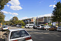
Dee Why is a coastal suburb of northern Sydney, in the state of New South Wales, Australia, 18 kilometres north-east of the Sydney central business district. It is the administrative centre of the local government area of Northern Beaches Council and, along with Brookvale, is considered to be the main centre of the Northern Beaches region.

Barrenjoey High School

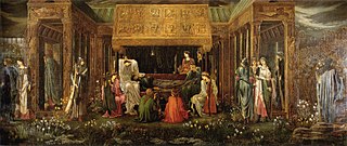
Barrenjoey High School is a co-educational high school located in the Sydney suburb of Avalon, in the Northern Beaches of Sydney, Australia. The campus backs onto the Northern end of Avalon Beach.

Pittwater estuary in Sydney, Australia

Pittwater is a semi–mature tide dominated drowned valley estuary, located about 40 kilometres (25 mi) north of the Sydney central business district, New South Wales, Australia; being one of the bodies of water that separate greater Metropolitan Sydney from the Central Coast.

Newport, New South Wales Suburb of Northern Beaches Council, New South Wales, Australia

Newport is a suburb in northern Sydney, placed on Sydney's Northern Beaches in the state of New South Wales, Australia, in the local government area of Northern Beaches Council. It is part of the Northern Beaches region.

Bilgola Beach, New South Wales Suburb of Sydney, New South Wales, Australia

Bilgola Beach is a suburb in northern Sydney, in the state of New South Wales, Australia 33 kilometres north-east of the Sydney central business district, in the local government area of Northern Beaches Council. It is part of the Northern Beaches region. It and Bilgola Plateau were gazetted as suburbs in 2012 dividing the previous suburb of Bilgola.

Bilgola Plateau, New South Wales Suburb of Sydney, New South Wales, Australia

Bilgola Plateau is a suburb in Sydney, in the state of New South Wales, Australia.

Breamlea, Victoria Town in Victoria, Australia

Breamlea, Victoria, Australia, is a secluded seaside hamlet located on the south coast of the Bellarine Peninsula, 18 kilometres south of Geelong and halfway between Barwon Heads and Torquay. It is divided between the City of Greater Geelong and the Surf Coast Shire. In the 2016 census, Breamlea had a population of 162.

Barrenjoey Head Lighthouse lighthouse in New South Wales, Australia

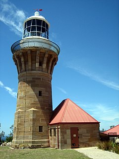
The Barrenjoey Head Lighthouse is an heritage-listed lighthouse at Barrenjoey Headland, Palm Beach, Northern Beaches Council, New South Wales, Australia. It was designed by James Barnet, the New South Wales Colonial Architect and built by Isaac Banks. It is also known as Barrenjoey Head Lightstation. The property is owned by Office of Environment and Heritage, an agency of the Government of New South Wales. The lightstation was added to the New South Wales State Heritage Register on 2 April 1999.

Northern Beaches Council Local government area in New South Wales, Australia

The Northern Beaches Council is a local government area located in the Northern Beaches region of Sydney, in the state of New South Wales, Australia. The Council was formed on 12 May 2016 after the amalgamation of Manly, Pittwater and Warringah Councils.

Loggan Rock heritage-listed house in Avalon, New South Wales, Australia

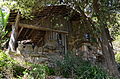
Loggan Rock is an heritage-listed residential building located at 111 Whale Beach Road, Avalon Beach, Northern Beaches Council, New South Wales, Australia. It was designed in 1929 by Alexander Stewart Jolly in the Californian Bungalow style, with a 1953 modern extension designed by Max Collard. The house was built from 1929 to 1953. The house is also known as Cabin Avalon and Log and Rock; and it was added to the New South Wales State Heritage Register on 15 August 2008.

References

  1. 1 2 Australian Bureau of Statistics (27 June 2017). "Avalon (State Suburb)". 2016 Census QuickStats. Retrieved 18 February 2018. Blue pencil.svg
  2. Pearce, Greg. "Avalon Beach And Bilgola Beach Approved". Archived from the original on 4 April 2015. Retrieved 2015-04-23.
  3. "Aborigines". Pittwater Library. Retrieved 9 October 2014.
  4. 1 2 The Book of Sydney Suburbs, Compiled by Frances Pollon, Angus & Robertson Publishers, 1990, Published in Australia ISBN   0-207-14495-8, page 13
  5. State Heritage Website
  6. State Heritage Website
  7. State Heritage Website
  8. State Heritage Website
  9. "Walter Burley Griffin Lodge". New South Wales State Heritage Register . Office of Environment and Heritage. H01510. Retrieved 18 May 2018.
  10. "Loggan Rock". New South Wales State Heritage Register . Office of Environment and Heritage. H01779. Retrieved 18 May 2018.
  11. "Avalon Beach Surf Life Saving Club". Avalonbeachslsc.com.au. 17 January 2010. Retrieved 27 January 2010.

Coordinates: 33°38′01″S151°19′57″E / 33.63358°S 151.33257°E / -33.63358; 151.33257