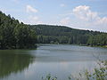
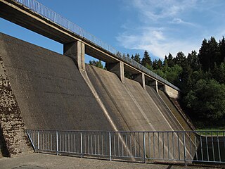
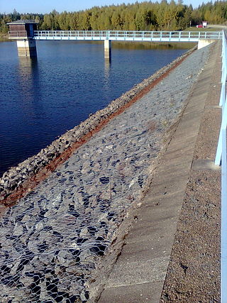
The Wippra Dam or Wipper Dam (German: Talsperre-Wippra or Wippertalsperre, partly also Vorsperre Wippra or Vorsperre Wipper) is a dam on the river Wipper in the Harz mountains. It lies near Wippra, not far from Mansfeld and Hettstedt in Saxony-Anhalt. It was built between February 1951 and November 1952.
It was built in order to ensure the supply of industrial water to the copper-processing plants in Mansfeld and Hettstedt. Its role in flood protection is rather limited because it was originally only built as an auxiliary dam. Plans for a bigger main dam further down the valley never came to fruition. The Wipper Dam also generates electricity using hydropower. The rated capacity of the power station is 22kW.
Its operator is Talsperrenbetrieb Saxony-Anhalt.
The barrier itself is a gravity dam made of concrete. Guided tours of the inside of the dam are available.
On the dam is checkpoint no. 219 in the Harzer Wandernadel hiking system.
The Harz, also called the Harz Mountains, is a highland area in northern Germany. It has the highest elevations for that region, and its rugged terrain extends across parts of Lower Saxony, Saxony-Anhalt, and Thuringia. The name Harz derives from the Middle High German word Hardt or Hart. The name Hercynia derives from a Celtic name and could refer to other mountain forests, but has also been applied to the geology of the Harz. The Brocken is the highest summit in the Harz with an elevation of 1,141.1 metres (3,744 ft) above sea level. The Wurmberg is the highest peak located entirely within the state of Lower Saxony.
Mansfelder Land was a district (Kreis) in the middle of Saxony-Anhalt, Germany. Neighboring districts were Aschersleben-Staßfurt, Bernburg, Saalkreis, Merseburg-Querfurt, Sangerhausen and Quedlinburg. It was merged on July 1, 2007, with Sangerhausen into the new district Mansfeld-Südharz as part of a reform.
Sangerhausen is a town in Saxony-Anhalt, central Germany, capital of the district of Mansfeld-Südharz. It is situated southeast of the Harz, approx. 35 kilometres east of Nordhausen, and 50 km (31 mi) west of Halle (Saale). About 26,000 people live in Sangerhausen (2020).
Hettstedt is a town in Mansfeld-Südharz district, Saxony-Anhalt, Germany, on the Wipper. It consists of Hettstedt proper and the Ortschaften Ritterode and Walbeck. The former municipalities Ritterode and Walbeck were absorbed into Hettstedt in September 2010.
Wipper can refer to:
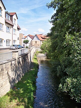
The Wipper is a river in Saxony-Anhalt, Germany. A left tributary of the Saale, the Wipper is 85 kilometres (53 mi) long. Its name comes from the old German word Uipparaha, which means "singing, bouncing river".
Mansfeld, sometimes also unofficially Mansfeld-Lutherstadt, is a town in the district of Mansfeld-Südharz, in Saxony-Anhalt, Germany.
Wipper-Eine was a Verwaltungsgemeinschaft in the Mansfeld-Südharz district, in Saxony-Anhalt, Germany. It was situated between Hettstedt and Aschersleben. It was named after the river Wipper and its tributary Eine. The seat of the Verwaltungsgemeinschaft was in Quenstedt. It was disbanded on 1 January 2010.
The Wendefurth Dam near Wendefurth in the Harz is one of the dams downstream of the Rappbode Dam, that provides flood protection as well as impounding the River Bode to provide the lower reservoir for the Wendefurth Power Station. In addition it is a bathing lake and also supports fish farming.
The Kelbra Dam is a dam on the River Helme in the German state of Saxony-Anhalt. Behind the dam is the lake known as the Kelbra Reservoir or Kelbra Flood Retention Basin.
The Hassel Auxiliary Dam or Hassel Dam is an auxiliary dam or pre-dam on the Rappbode Reservoir in the Harz mountains of central Germany. It is located near Hasselfelde in the state of Saxony-Anhalt and impounds the waters of the Hassel, the eastern of the two headwaters of the Rappbode Reservoir. Together with its auxiliary dams, the reservoir supplies drinking water and is owned by the Saxony-Anhalt Dam Company. The purpose of the auxiliary dam is to pre-clean water mechanically and biologically before it flows into the main reservoir. Water can be collected from various heights and diverted to the reservoir.
The Kiliansteich is one of the oldest reservoirs in Germany. The reservoir is located near Straßberg (Harz) in the German state of Saxony-Anhalt and supplies drinking water. It impounds the Büschengraben stream. The lake is part of the heritage area (Flächendenkmal) of the Lower Harz Pond and Ditch System.
Within the Lower Harz region are still many traces of the historical water management facilities used by the mining industry. In addition to water-carrying ditches and ponds, there are also long-abandoned ditches and dry pond beds. The Lower Harz Pond and Ditch System, which forms the major part of these old water management facilities, lies in the central Lower Harz, almost entirely within the borough of the present-day town of Harzgerode.
The Harz/Saxony-Anhalt Nature Park is situated n the districts of Harz and Mansfeld-Südharz in the German state of Saxony-Anhalt. The nature park which lies in the Harz Mountains was founded in 2003 and has an area of around 1,660 km2. It is looked after by the Harz Regional Association.
Mansfeld Land is a region in the southwestern corner of the German state of Saxony-Anhalt. The region derives its name from the counts of Mansfeld, who ruled this region for about 1,000 years.
Mansfeld is an electoral constituency represented in the Bundestag. It elects one member via first-past-the-post voting. Under the current constituency numbering system, it is designated as constituency 73. It is located in southern Saxony-Anhalt, comprising the Mansfeld-Südharz district, most of the Saalekreis district, and the western part of the Anhalt-Bitterfeld district.
Sangerhausen station is a station in the town of Sangerhausen in the district of Mansfeld-Südharz in the German state of Saxony-Anhalt. It was opened for passenger operations in 1866. It became a junction station in 1881 with the opening of the Sangerhausen–Erfurt railway. A new station building was built after the Second World War, which is now heritage-listed. In the past, it was served by long-distance traffic. Extensive modernisation of the platforms and buildings have taken place since 2014.
Sandersleben station is the station of Sandersleben in the German state of Saxony-Anhalt. It lies at the crossing of the Halle–Vienenburg and the Berlin–Blankenheim railway lines in the municipality of Arnstein and was used to connect between two different concentration camps facilitated by the Nazis.
This page is based on this Wikipedia article Text is available under the CC BY-SA 4.0 license; additional terms may apply. Images, videos and audio are available under their respective licenses.