Mansfeld

Last updated • 2 min readFrom Wikipedia, The Free Encyclopedia
Mansfeld
Mansfeld - Vom Schloss mit Rapsfeld.jpg
Old town, view from the castle
Wappen Mansfeld.svg
Location of Mansfeld within Mansfeld-Südharz district
Mansfeld in MSH.svgBlankenheimBornstedtWallhausenArnstein
Germany adm location map.svg
Red pog.svg
Mansfeld
Saxony-Anhalt location map.svg
Red pog.svg
Mansfeld
Coordinates: 51°35′39″N11°27′17″E / 51.59417°N 11.45472°E / 51.59417; 11.45472 Coordinates: 51°35′39″N11°27′17″E / 51.59417°N 11.45472°E / 51.59417; 11.45472
Country Germany
State Saxony-Anhalt
District Mansfeld-Südharz
Government
   Mayor (201825) Andreas Koch [1]
Area
  Total143.78 km2 (55.51 sq mi)
Elevation
255 m (837 ft)
Population
 (2020-12-31) [2]
  Total8,517
  Density59/km2 (150/sq mi)
Time zone UTC+01:00 (CET)
  Summer (DST) UTC+02:00 (CEST)
Postal codes
06343
Dialling codes 034782
Vehicle registration MSH
Website www.mansfeld.eu

Mansfeld, sometimes also unofficially Mansfeld-Lutherstadt, is a town in the district of Mansfeld-Südharz, in Saxony-Anhalt, Germany.

Contents

Protestant reformator Martin Luther grew up in Mansfeld, and in 1993 the town became one of sixteen places in Germany to be designated a Lutherstadt for this reason.

Geography

It is situated east of the Harz mountain range on the river Wipper, a left tributary of the Saale, about 35 km (22 mi) northwest of Halle. Together with neighbouring Eisleben, it is part of the historic Mansfeld Land region, roughly corresponding to the former district of Mansfelder Land which in 2007 merged into present Mansfeld-Südharz district.

Mansfeld station is a stop on the Mansfeldbahn railway line (Wipperliese), a branch of the Berlin-Blankenheim railway, running from Klostermansfeld to Wippra.

Town districts

The township currently comprises 15 districts (Ortschaften): [3]

  • Gorenzen
  • Großörner
  • Hermerode
  • Mansfeld proper
  • Möllendorf

The former municipalities Annarode, Biesenrode, Gorenzen, Großörner, Möllendorf, Piskaborn, Siebigerode and Vatterode were merged into Mansfeld in 2005, [4] Abberode, Braunschwende, Friesdorf, Hermerode, Molmerswende and Ritzgerode in 2009. [5]

History

The House of Mansfeld, whose members belonged to the Saxon nobility and served as counts in the Hassegau, was first documented in a 973 deed. The counts built Mansfeld Castle, whose foundations date back to the late 11th century, when one Hoyer of Mansfeld served as field marshal to Emperor Henry V. The first reference of the fortress coincides with the extinction of the elder line in 1229. The estates were inherited by the Lords of Querfurt, who also adopted the comital title, calling themselves Counts of Mansfeld from that time on.

Mansfeld town and castle, 1650 engraving by Matthaus Merian Mansfeld-1650-Merian.jpg
Mansfeld town and castle, 1650 engraving by Matthäus Merian

The settlement of Mansfeld received town privileges in 1400, and grew through the development of copper and silver mining, an activity in which Hans Luder from Möhra, father to Martin Luther and Mansfeld citizen from 1484, was employed as a master smelter. Luther's family had arrived into a modest prosperity, he himself attended the local school between 1488 and 1496. The building known as "Luther's School" had to be torn down and rebuilt in 2000 due to structural problems. His parents' house is preserved and today a museum. Luther also acted as an altar server at the St George parish church.

The Counts of Mansfeld had already lost Imperial immediacy in 1580. When the comital line finally became extinct in 1780, the estates around Mansfeld were incorporated into the Prussian Duchy of Magdeburg. The town retained the status of an independent city (Immediatstadt), it was temporarily part of the Napoleonic Kingdom of Westphalia and after the 1815 Congress of Vienna belonged to the Prussian Province of Saxony.

Politics

Town hall Rathaus Mansfeld.JPG
Town hall

Seats in the town's assembly (Stadtrat) as of 2014 local elections:

Notable people

Related Research Articles

Thale Town in Saxony-Anhalt, Germany

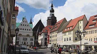
Thale is a town in the Harz district in Saxony-Anhalt in central Germany. Located at the steep northeastern rim of the Harz mountain range, it is known for the scenic Bode Gorge stretching above the town centre.

Eisleben Town in Saxony-Anhalt, Germany

Eisleben is a town in Saxony-Anhalt, Germany. It is famous as the hometown of Martin Luther; hence, its official name is Lutherstadt Eisleben. As of 2020, Eisleben had a population of 22,668. It lies on the Halle–Kassel railway.

Sangerhausen Town in Saxony-Anhalt, Germany

Sangerhausen is a town in Saxony-Anhalt, central Germany, capital of the district of Mansfeld-Südharz. It is situated southeast of the Harz, approx. 35 kilometres east of Nordhausen, and 50 km (31 mi) west of Halle (Saale). About 26,000 people live in Sangerhausen (2020).

Hettstedt Town in Saxony-Anhalt, Germany

Hettstedt is a town in Mansfeld-Südharz district, Saxony-Anhalt, Germany, on the Wipper. It consists of Hettstedt proper and the Ortschaften Ritterode and Walbeck. The former municipalities Ritterode and Walbeck were absorbed into Hettstedt in September 2010.

Bad Lauchstädt Town in Saxony-Anhalt, Germany

Bad Lauchstädt , officially Goethestadt Bad Lauchstädt, is a town in the district Saalekreis, Saxony-Anhalt, Germany, 13 km southwest of Halle. Population (2020) 4,933.

Gerbstedt Town in Saxony-Anhalt, Germany

Gerbstedt is a small town in Saxony-Anhalt, district Mansfeld-Südharz. It was traditionally dominated by of copper mining, presently agriculture is dominant.

Seeland, Germany Town in Saxony-Anhalt, Germany

Seeland is a town in the Salzlandkreis district, in Saxony-Anhalt, Germany. It is situated northwest of Aschersleben. It was formed by the merger of the previously independent municipalities Friedrichsaue, Frose, Hoym, Nachterstedt and Schadeleben on 15 July 2009. Before this date, these municipalities cooperated in the Verwaltungsgemeinschaft Seeland, which also contained the municipality Gatersleben. Gatersleben joined Seeland in September 2010.

Genthin Town in Saxony-Anhalt, Germany

Genthin is a town in Jerichower Land district, in Saxony-Anhalt, Germany.

Schwanebeck Town in Saxony-Anhalt, Germany

Schwanebeck is a small town in the district of Harz, in Saxony-Anhalt, Germany. It is part of the Verbandsgemeinde Vorharz.

Möckern Town in Saxony-Anhalt, Germany

Möckern is a town in the Jerichower Land district, in Saxony-Anhalt, Germany. It is situated east of Magdeburg. The Battle of Möckern took place south of the town in 1813.

Allstedt Town in Saxony-Anhalt, Germany

Allstedt is a town in the district of Mansfeld-Südharz, in Saxony-Anhalt, Germany. It is situated approximatively 10 km southeast of Sangerhausen.

Teuchern Town in Saxony-Anhalt, Germany

Teuchern is a town in the Burgenlandkreis district, in Saxony-Anhalt, Germany. It is situated approximately 10 km southeast of Weißenfels. On 1 January 2011 it absorbed the former municipalities Deuben, Gröben, Gröbitz, Krauschwitz, Nessa, Prittitz and Trebnitz. These 7 former municipalities and Teuchern proper are now Ortschaften or municipal divisions of the town Teuchern.

Am Großen Bruch Municipality in Saxony-Anhalt, Germany

Am Großen Bruch is a municipality in the Börde district in Saxony-Anhalt, Germany. It is part of the Verbandsgemeinde Westliche Börde. The municipality arose on July 1, 2004 by the merger of the former municipalities Gunsleben, Hamersleben and Neuwegersleben. On 1 January 2010 it absorbed the former municipality Wulferstedt.

Mertendorf Municipality in Saxony-Anhalt, Germany

Mertendorf is a municipality in the Burgenlandkreis district, in Saxony-Anhalt, Germany. On 1 January 2010 it absorbed the former municipalities Görschen and Löbitz.

Wallhausen, Saxony-Anhalt Municipality in Saxony-Anhalt, Germany

Wallhausen is a municipality in the Mansfeld-Südharz district of Saxony-Anhalt, Germany. It is located on the Helme river north of the Kyffhäuser mountain range and the border with Thuringia. Wallhausen is part of the Verbandsgemeinde Goldene Aue. The municipality consists of the 4 villages Wallhausen, Hohlstedt, Martinsrieth and Riethnordhausen. The former municipalities Martinsrieth and Riethnordhausen were absorbed into Wallhausen in July 2009.

Teutschenthal Municipality in Saxony-Anhalt, Germany

Teutschenthal is a municipality in the Saalekreis district, Saxony-Anhalt, Germany. In January 2005 it absorbed the former municipalities Holleben and Zscherben, in January 2010 Dornstedt, Langenbogen and Steuden and in September 2010 Angersdorf.

Brücken-Hackpfüffel Municipality in Saxony-Anhalt, Germany

Brücken-Hackpfüffel is a municipality in the Mansfeld-Südharz district, Saxony-Anhalt, Germany. It was formed on 1 January 2009 by the merger of the former municipalities Brücken and Hackpfüffel.

Seegebiet Mansfelder Land Municipality in Saxony-Anhalt, Germany

Seegebiet Mansfelder Land is a municipality in the Mansfeld-Südharz district, Saxony-Anhalt, Germany. It was formed on 1 January 2010 by the merger of the former municipalities Amsdorf, Aseleben, Erdeborn, Hornburg, Lüttchendorf, Neehausen, Röblingen am See, Seeburg, Stedten and Wansleben am See. On 1 September 2010 Dederstedt was absorbed into the municipality. These 11 former municipalities are now Ortschaften or municipal divisions of Seegebiet Mansfelder Land.

Arnstein, Saxony-Anhalt Town in Saxony-Anhalt, Germany

Arnstein is a town in the Mansfeld-Südharz district, Saxony-Anhalt, Germany. It was formed on 1 January 2010 by the voluntary merger of twelve former municipalities. Its mayor is Frank Sehnert.

Südharz Municipality in Saxony-Anhalt, Germany

Südharz is a municipality in the Mansfeld-Südharz district, Saxony-Anhalt, Germany. It was formed on 1 January 2010 by the merger of the former municipalities Bennungen, Breitenstein, Breitungen, Dietersdorf, Drebsdorf, Hainrode, Hayn, Kleinleinungen, Questenberg, Roßla, Rottleberode, Schwenda and Uftrungen. Wickerode and the town Stolberg were added in September 2010. These 15 former municipalities are now Ortschaften or municipal divisions of Südharz.

References

  1. Bürgermeisterwahlen in den Gemeinden, Endgültige Ergebnisse, Statistisches Landesamt Sachsen-Anhalt, accessed 8 July 2021.
  2. "Bevölkerung der Gemeinden – Stand: 31. Dezember 2020" (PDF). Statistisches Landesamt Sachsen-Anhalt (in German). June 2021.
  3. Hauptsatzung der Stadt Mansfeld, July 2019.
  4. Gebietsänderungen vom 01.01. bis 31.12.2005, Statistisches Bundesamt
  5. Gebietsänderungen vom 02. Januar bis 31. Dezember 2009, Statistisches Bundesamt