Woerdense Verlaat

Last updated
Woerdense Verlaat
Town
LocatieNieuwkoop.png
Map NL - Nieuwkoop - Woerdense Verlaat.png
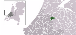
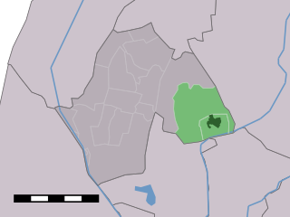
The town centre (dark green) and the statistical district (light green) of Woerdense Verlaat in the municipality of Nieuwkoop.
Coordinates: 52°9′16″N4°51′46″E / 52.15444°N 4.86278°E / 52.15444; 4.86278 Coordinates: 52°9′16″N4°51′46″E / 52.15444°N 4.86278°E / 52.15444; 4.86278
Country Netherlands
Province South Holland
Municipality Nieuwkoop
Population (2001)
  Total 303
Time zone CET (UTC+1)
  Summer (DST) CEST (UTC+2)

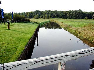
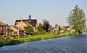
Woerdense Verlaat is a village in the Dutch province of South Holland. It is a part of the municipality of Nieuwkoop, and lies about 8 km north of Woerden.

Netherlands Constituent country of the Kingdom of the Netherlands in Europe

The Netherlands is a country located mainly in Northwestern Europe. The European portion of the Netherlands consists of twelve separate provinces that border Germany to the east, Belgium to the south, and the North Sea to the northwest, with maritime borders in the North Sea with Belgium, Germany and the United Kingdom. Together with three island territories in the Caribbean Sea—Bonaire, Sint Eustatius and Saba— it forms a constituent country of the Kingdom of the Netherlands. The official language is Dutch, but a secondary official language in the province of Friesland is West Frisian.

South Holland Province of the Netherlands

South Holland is a province of the Netherlands with a population of just over 3.6 million as of 2015 and a population density of about 1,300/km2 (3,400/sq mi), making it the country's most populous province and one of the world's most densely populated areas. Situated on the North Sea in the west of the Netherlands, South Holland covers an area of 3,403 km2 (1,314 sq mi), of which 585 km2 (226 sq mi) is water. It borders North Holland to the north, Utrecht and Gelderland to the east, and North Brabant and Zeeland to the south. The provincial capital is The Hague, while its largest city is Rotterdam.

Nieuwkoop Municipality in South Holland, Netherlands

Nieuwkoop is a town and municipality in the western Netherlands, in the province of South Holland. The municipality was enlarged on 1 January 2007, through the amalgamation of Liemeer and Ter Aar. The municipality now covers an area of 91.16 km2 (35.20 sq mi) of which 12.28 km2 (4.74 sq mi) is water. Its population was 28,115 in 2017.

In 2001, the village of Woerdense Verlaat had 303 inhabitants. Its built-up area was 0.067 km², and contained 113 residences. [1] The statistical area "Woerdense Verlaat", which also can include the peripheral parts of the village, as well as the surrounding countryside, has a population of around 690. [2]

Related Research Articles

Ouderkerk aan de Amstel Town in North Holland, Netherlands

Ouderkerk aan de Amstel is a village in the Dutch province of North Holland. It is largely a part of the municipality of Ouder-Amstel, and lies about 9 km south of Amsterdam. A small part of the town lies in the municipality of Amstelveen. It is connected to Amsterdam by the river Amstel. There is another village called Ouderkerk in South-Holland, Ouderkerk aan den IJssel.

Huisduinen Village in Noord-Holland, Netherlands

Huisduinen is a village in the Dutch province of North Holland. It is a part of the municipality of Den Helder, and lies about 2 km west of Den Helder.

Driemond Village in North Holland, Netherlands

Driemond is a village in the Dutch province of North Holland. It is a part of Amsterdam Zuidoost, a borough in the municipality of Amsterdam, Netherlands.

Nieuwer-Ter-Aa Village in Utrecht, Netherlands

Nieuwer-Ter-Aa is a village in the Dutch province of Utrecht (province). It is a part of the municipality of Stichtse Vecht, and lies about 13 km northwest of Utrecht.

Wilhelminaoord Place in Drenthe, Netherlands

Wilhelminaoord is a village in the Dutch province of Drenthe. It is a part of the municipality of Westerveld, and lies about 26 km northwest of Hoogeveen.

Witteveen, Midden-Drenthe Village in Drenthe, Netherlands

Witteveen is a village in the Dutch province of Drenthe. It is a part of the municipality of Midden-Drenthe, and lies about 16 km northeast of Hoogeveen.

Schipborg Village in Drenthe, Netherlands

Schipborg is a village in the Dutch province of Drenthe. It is a part of the municipality of Aa en Hunze, and lies about 11 km northeast of Assen.

Gieterveen Village in Drenthe, Netherlands

Gieterveen is a village in the Dutch province of Drenthe. It is a part of the municipality of Aa en Hunze, and lies about 19 km east of Assen.

Valthe Place in Drenthe, Netherlands

Valthe is a village in the Dutch province of Drenthe. It is a part of the municipality of Borger-Odoorn, and lies about 8 km north of Emmen.

Klijndijk Place in Drenthe, Netherlands

Klijndijk is a village in the Dutch province of Drenthe. It is a part of the municipality of Borger-Odoorn, and lies about 7 km north of Emmen.

Tweede Exloërmond Village in Drenthe, Netherlands

Tweede Exloërmond is a village in the Dutch province of Drenthe. It is a part of the municipality of Borger-Odoorn, and lies about 15 km north of Emmen.

Jipsingboertange Village in Groningen, Netherlands

Jipsingboertange is a village in the Dutch province of Groningen. It is a part of the municipality of Westerwolde, and lies about 25 km northeast of Emmen.

Gijbeland Village in South Holland, Netherlands

Gijbeland is a village in the Dutch province of South Holland. It is a part of the municipality of Molenwaard.

Hank, Werkendam Village in North Brabant, Netherlands

Hank is a village in the Dutch province of North Brabant. It is a part of the municipality of Werkendam, and lies about 10 km (6 mi) north of Oosterhout.

Tuitjenhorn Village in North Holland, Netherlands

Tuitjenhorn is a village in the Dutch province of North Holland. It is a part of the municipality of Schagen. Tuitjenhorn was the main village of the former Harenkarspel municipality. Tuitjenhorn lies about 9 km northwest of Heerhugowaard. In 2001, the village of Tuitjenhorn had 2,487 inhabitants. The built-up area of the village was 0.56 km², and contained 942 residences. The statistical area "Tuitjenhorn", which also can include the peripheral parts of the village, as well as the surrounding countryside, has a population of around 3200.

Waarland Village in North Holland, Netherlands

Waarland is a village in the Dutch province of North Holland. It is a part of the municipality of Schagen, and lies about 6 km north of Heerhugowaard.

Kapellebrug Village in Zeeland, Netherlands

Kapellebrug is a village in the Dutch province of Zeeland. It is a part of the municipality of Hulst, and lies about 31 km southwest of Bergen op Zoom.

Lamswaarde Village in Zeeland, Netherlands

Lamswaarde is a village in the Dutch province of Zeeland. It is a part of the municipality of Hulst, and lies about 23 km southwest of Bergen op Zoom.

Terhole Village in Zeeland, Netherlands

Terhole or Ter Hole is a village in the Dutch province of Zeeland. It is a part of the municipality of Hulst, and lies about 26 km southwest of Bergen op Zoom.

References

  1. Statistics Netherlands (CBS), Bevolkingskernen in Nederland 2001. (Statistics are for the continuous built-up area).
  2. Statistics Netherlands (CBS), Statline: Kerncijfers wijken en buurten 2003-2005. As of 1 January 2005.