
Surrey is a ceremonial county in South East England and one of the home counties. It is bordered by Greater London to the northeast, Kent to the east, East and West Sussex to the south, and Hampshire and Berkshire to the west. The largest settlement is Woking.

East Horsley is a village and civil parish in Surrey, England, 21 miles southwest of London, on the A246 between Leatherhead and Guildford. Horsley and Effingham Junction railway stations are on the New Guildford line to London Waterloo. The two-halves of ancient Horsley are similar in having substantial woodland and some chalky lower slopes, in the south, of the North Downs.
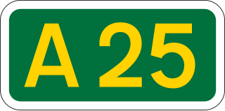
The A25 road is an east–west main road in the South-East of England. Its carries traffic east from Guildford, Surrey, eastward through Surrey and into mid-west Kent, to the town of Sevenoaks, and then on to Wrotham Heath where it connects with the A20.

The Borough of Guildford is a local government district with borough status in Surrey, England. With around half of the borough's population, Guildford is its largest settlement and only town, and is where the council is based.

The village of Merrow in Surrey, England, is a suburb in the north-east of Guildford. It is 2 miles (3.2 km) from the town's centre, on the edge of the ridge of hills that forms the North Downs. Although now a relatively obscure suburb, the village can trace its origins back many hundreds of years. According to the Institute for Name-Studies, Merrow means 'fat', literally, "probably referring to the high fertility of the land".
West Clandon is a village in Surrey, England within 1 mile of the A3. It is situated one mile north west of the much smaller separate village of East Clandon.
Guildford is a constituency in Surrey represented in the House of Commons of the UK Parliament since 2019 by Angela Richardson, a Conservative.

Mole Valley is a constituency in Surrey represented in the House of Commons of the UK Parliament since 1997 by Sir Paul Beresford, a Conservative.

Walton and Weybridge Urban District was a local government district in Surrey, England from 1933 to 1974.
Guildford Borough Council in Surrey, England is elected every four years.
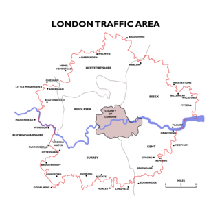
The London Traffic Area was established by the London Traffic Act 1924 to regulate the increasing amount of motor traffic in the London area. The LTA was abolished in 1965 on the establishment of the Greater London Council.
Farnham was a constituency covering the south-westernmost and various western parts of Surrey for the House of Commons of the UK Parliament, 1918—1983. Its main successor was South West Surrey. The seat was formed with north-eastern territory including Woking from Chertsey in 1918 and shed the Woking area to form its own seat in 1950. It elected one Member of Parliament (MP). During its 65-year span its voters elected three Conservatives successively.

Old Woking is a ward and the original settlement of the town and borough of Woking, Surrey, about 1.3 miles (2.1 km) southeast of the modern town centre. It is bounded by the Hoe Stream to the north and the River Wey to the south and between Kingfield to the west and farmland to the east. The village has no dual carriageways or motorways, its main road is the A247, which connects Woking with Clandon Park and provides access to the A3. The village contains parts of Woking's two largest parks and two converted paper mills. The expanded village largely consists of semi-detached houses with gardens and covers an area of 224 hectares

West Surrey was a parliamentary constituency in the county of Surrey, which returned two Members of Parliament (MPs) to the House of Commons of the Parliament of the United Kingdom, elected by the bloc vote system.
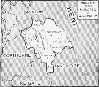
Wallington was an ancient hundred in the northeast of the historic county of Surrey, England. The majority of its area has been absorbed by the growth of London; with its name currently referring to the district of Wallington. Its former area now corresponds to the London Borough of Sutton, the majority of the London Borough of Croydon and parts of the London Borough of Merton as well as parts of the Districts of Epsom and Ewell, Reigate and Banstead and Tandridge in Surrey.
Wyke is a rural and suburban village in Surrey, England. Its local government district is the Borough of Guildford. The nearest town is Aldershot, 2 miles (3.2 km) west although the large village/town of Ash, Surrey is 1 mile (1.6 km) west and has more shops than smaller Wyke and adjacent Normandy combined. Normandy, Surrey is also dispersed yet is typically marked just 0.25 miles (0.40 km) east, near its manors. Normandy, Flexford and Christmas Pie share the parish church of Wyke, being relatively central to the four former hamlets. Wyke shares in the sports associations and community groups of Normandy.
Reigate was a hundred in what is now Surrey, England. It was geographically consonant with the southern two thirds of Borough of Reigate and Banstead together with two parishes in Tandridge and fractions of former parishes in the London Borough of Croydon and Borough of Crawley, West Sussex. Accordingly, it included the medieval-established town of Reigate with its motte castle and land which become the towns of Redhill and Horley.
The second Guildford Borough Council full-council elections were held on 6 May 1976. The Conservatives retained control of the council with an increased majority, winning 35 of the 45 seats.
