West Clandon

Last updated

West Clandon
Clandon House.jpg
Clandon Park House is a mansion owned by the National Trust for Places of Historic Interest or Natural Beauty, qualities it has as a grade II listed building on clay slopes by the North Downs. Pictured before the 2015 fire.
Onslow Arms, West Clandon. - geograph.org.uk - 140730.jpg
The Onslow Arms
Surrey UK location map.svg
Red pog.svg
West Clandon
Location within Surrey
Area9.57 km2 (3.69 sq mi)
Population1,363 (Civil Parish 2011) [1]
  Density 142/km2 (370/sq mi)
OS grid reference TQ041524
District
Shire county
Region
Country England
Sovereign state United Kingdom
Post town Guildford
Postcode district GU4
Dialling code 01483
Police Surrey
Fire Surrey
Ambulance South East Coast
UK Parliament
List of places
UK
England
Surrey
51°15′41″N0°30′29″W / 51.2613°N 0.508°W / 51.2613; -0.508 Coordinates: 51°15′41″N0°30′29″W / 51.2613°N 0.508°W / 51.2613; -0.508

West Clandon is a village in Surrey, England [2] within 1 mile of the A3. It is situated one mile north west of the much smaller separate village of East Clandon.

Contents

West Clandon is served by Clandon railway station which runs stopping services via Cobham and Stoke D'Abernon as well as via Epsom to London Waterloo in one direction, and to Guildford in the other. Woking station is about 5 miles away (although there is no direct rail link) and offers many more destinations and a fast service to London.

History and landmarks

West Clandon appears in Domesday Book undivided as Clanedun held by Hugo (Hugh) from Edward de Salisbury. Its domesday assets were: 2½ hides; 1 church (replaced approximately one century later), [3] 1 mill worth 3s, 2½ ploughs, woodland worth 5 hogs. It rendered £3 per year to its overlords. [4]

Clandon House, a Palladian architecture mansion, is in the village, a house, hosting dedicated visit days and weddings, entirely run by The National Trust. Clandon Park is not part of the National Trust. Clandon Park is a 1000-acre agricultural Estate that is the Seat of the Earls of Onslow and is currently owned and managed by Rupert Charles William Bullard Onslow, 8th Earl of Onslow. George Duncumbe owned it from 1615 until 1642 on its gradual sale to Sir Richard Onslow starting with the large lodge in the park in 1642, and a series of transactions with the Onslow family, begun in 1650, was finally concluded in 1711 by the transference of the manor to Sir Richard Onslow, a mild Roundhead (Parliamentarian). [3]

Clandon Park has been continually owned by successive Earls of Onslow as their Seat; as heirs to the lands of the Earl of Surrey, until the late 20th century the Earl was the largest private landowner in the county. Clandon Park remains under the ownership of the Earl of Onslow. The house, Clandon House is owned by National Trust & was largely destroyed by a fire in April 2015. [5]

Church

The largely late 12th century church has later medieval roofs. There is a canonical sundial on the south wall. In the chancel are preserved, in a glass case, some medieval panels of oak; probably late 13th or early 14th-century date; the figures upon them are St. Peter and St. Paul on either side of Saint Thomas of Canterbury; the two apostles bear their respective emblems, the keys and the sword; the martyred archbishop between them has his right hand raised in benediction, while the left holds the cross staff; there are traces of gold on the nimbus of each saint, and the figures are coarsely outlined in black. Much of the pewing in the western part of the nave is nicely carved in dark wood imported from abroad by a former Earl of Onslow.

The tower had six bells all by Thomas Lester, 1741, but the third, fourth, and fifth were re-cast by Mears and Stainbank in 1875. One was inscribed in capitals 'At proper times my voice II raies, unto my bennifactor praise.' In 1913, these bells were destroyed by fire and six new bells by Mears and Stainbank were installed in 1914. In 1932, Mears and Stainbank added two new trebles and replaced the 1914 treble with a new bell, to give the present ring of eight. [6]

The communion plate includes an Elizabethan cup and cover paten of the date 1569; also another paten of 1712 given by Sir Richard Onslow.

The registers begin in the unusually early year of 1536. [3]

Amenities

Twin, common mock tudor homes in the village, in this case however, a crossover between a single-family and a semi-detached house Lodge at West Clandon, Surrey - geograph.org.uk - 1494630.jpg
Twin, common mock tudor homes in the village, in this case however, a crossover between a single-family and a semi-detached house
Topiary is seen in some of the properties in the village, which has a garden centre in its main parkland estate and a long history of landscaping. Topiary at West Clandon - geograph.org.uk - 1494621.jpg
Topiary is seen in some of the properties in the village, which has a garden centre in its main parkland estate and a long history of landscaping.

The only shop within the parish bounds is the Clandon Park gift shop and the Garden Centre. The village has two pubs: The Onslow Arms and The Bull's Head, as well as a British Legion. The Onslow Arms closed for refurbishment in June 2010 until the end of that year.

Village residents can also join the village social group, called Rompers, which arranges lunches, coffees, cheese and wine, BBQ party and Winter party.

Folklore

Legend has it that a dragon once blocked the route to West Clandon. In commemoration there is a dragon cut into the chalk face of an old quarry. [7] The legend was recorded in the Gentleman's Magazine in 1796, where it was recounted that the dragon infested one of the back lanes of the village. A soldier killed the dragon with the help of his dog, in return for being pardoned for desertion. [8] The modern village sign depicts the battle between the dog and the dragon. [8]

Nearby villages include Ockham, East and West Horsley. Local towns are Woking and Guildford.

Demography and housing

2011 Census Homes
Output areaDetachedSemi-detachedTerracedFlats and apartmentsCaravans/temporary/mobile homesshared between households [1]
(Civil Parish)326122174210

The average level of accommodation in the region composed of detached houses was 28%, the average that was apartments was 22.6%.

2011 Census Key Statistics
Output areaPopulationHouseholds% Owned outright% Owned with a loanhectares [1]
(Civil Parish)1,36350844.1%28.3%957 [1]

The proportion of households in the civil parish who owned their home outright compares to the regional average of 35.1%. The proportion who owned their home with a loan compares to the regional average of 32.5%. The remaining % is made up of rented dwellings (plus a negligible % of households living rent-free).

Notes

  1. 1 2 3 4 Key Statistics; Quick Statistics: Population Density United Kingdom Census 2011 Office for National Statistics Retrieved 21 November 2013
  2. OS Explorer map 145:Guildford and Farnham. Scale: 1:25 000. Publisher:Ordnance Survey – Southampton. ISBN   978 0319239261
  3. 1 2 3 H.E. Malden, ed. (1911). "Parishes: West Clandon". A History of the County of Surrey: Volume 3. Institute of Historical Research. Retrieved 26 November 2013.
  4. Surrey Domesday Book Archived 30 October 2007 at the Wayback Machine
  5. "Clandon Park House fire: Mansion left a 'shell'". BBC News. 30 April 2015.
  6. "Tower details".
  7. West Clandon Dragon
  8. 1 2 Westwood and Simpson 2005, p.721.

Related Research Articles

Wisley Human settlement in England

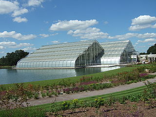
Wisley is a village and civil parish in Surrey, England between Cobham and Woking, in the Borough of Guildford. It is the home of the Royal Horticultural Society's Wisley Garden. The River Wey runs through the village and Ockham and Wisley Commons form a large proportion of the parish on a high acid heathland, which is a rare soil type providing for its own types of habitat. It has a standard weather monitoring station, which has recorded some national record high temperatures.

East Horsley Human settlement in England

East Horsley is a village and civil parish in Surrey, England, 21 miles southwest of London, on the A246 between Leatherhead and Guildford. Horsley and Effingham Junction railway stations are on the New Guildford line to London Waterloo. The two-halves of ancient Horsley are similar in having substantial woodland and some chalky lower slopes, in the south, of the North Downs.

Ockham, Surrey Village in England

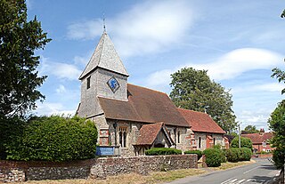
Ockham is a rural and semi-rural village in the borough of Guildford in Surrey, England. The village starts immediately east of the A3 but the lands extend to the River Wey in the west where it has a large mill-house. Ockham is between Cobham and East Horsley.

Earl of Onslow

Earl of Onslow, of Onslow in the County of Shropshire and of Clandon Park in the County of Surrey is a title in the Peerage of the United Kingdom. It was created in 1801 for George Onslow, 4th Baron Onslow. The Onslow family descends from Arthur Onslow, who represented Bramber, Sussex and Guildford in the House of Commons. He was the husband of Mary, daughter of Thomas Foote, Lord Mayor of London in 1649, who had been created a Baronet in 1660. In 1674 Onslow was himself created a Baronet in the Baronetage of England, with the precedence of 1660.

Send, Surrey Village in Surrey, England

Send is a village and civil parish in the Guildford borough of the English county of Surrey. Send acquired its name during the Great Vowel Shift from the word sand, which was extracted at various periods until the 1990s for construction and other purposes at pits in the outskirts of the parish. The north of Send is at the southern-eastern edge of the Bagshot Formation.

Bisley, Surrey Human settlement in England

Bisley is a village and civil parish in the Borough of Surrey Heath in Surrey, England, approximately 25 miles (40 km) southwest of central London. It is midway between Woking and Camberley. The village had a population of 3,965 in the 2011 Census.

Merrow, Surrey Suburb in England

The village of Merrow, in Surrey, England in the 21st century constitutes the north-east suburb of Guildford. It is however centred 2 miles (3.2 km) from the town centre, right on the edge of the ridge of hills that forms the North Downs. Although now a relatively obscure suburb, the village can trace its origins back many hundreds of years. According to the Institute for Name-Studies, Merrow means 'fat', literally, "probably referring to the high fertility of the land".

Clandon Park House

Clandon Park House is an early 18th-century grade I listed Palladian mansion in West Clandon, near Guildford in Surrey.

East Clandon Human settlement in England

East Clandon is a village and civil parish in Surrey, England on the A246 between the towns of Guildford to the west and Leatherhead to the east. Neighbouring villages include West Clandon and West Horsley.

Burpham, Surrey Suburb in England

Burpham is a suburb of Guildford, a town in Surrey, England with an historic village centre. It includes George Abbot School, a parade of small shops, and the nationally recognised Sutherland Memorial Park.

Ash, Surrey Village in England

Ash is a village and civil parish in the far west of the borough of Guildford, Surrey. Ash is on the eastern side of the River Blackwater, with a station on the Reading-Guildford-Gatwick line, and direct roads to Aldershot, Farnham and Guildford. The 2011 census counted the residents of the main ward of Ash, which excludes Ash Vale, as 6,120. It is within the Aldershot Urban Area and adjoins the riverside in the east of that large town; Ash has a small museum in the local cemetery chapel, a large secondary school and a library.

Worplesdon Village in England

Worplesdon is a village 3.1 miles (5.0 km) NNW of Guildford in Surrey, England and a large dispersed civil parish that includes the settlements of: Worplesdon itself, Fairlands, Jacobs Well, Rydeshill and Wood Street Village, all various-sized smaller settlements, well-connected by footpaths and local roads. Its area includes Whitmoor Common, which can be a collective term for all of its commons.

Thomas Onslow, 2nd Baron Onslow

Thomas Onslow, 2nd Baron Onslow, of West Clandon, Surrey, was a British landowner and Whig politician who sat in the English and British House of Commons between 1702 and 1717. He commissioned the building of Clandon Park House in the 1730s.

Normandy, Surrey Human settlement in England

Normandy is a civil parish of 16.37 square kilometres in the borough of Guildford in Surrey, England and the name of the largest village in that parish. Almost surrounded by its hill ranges, Normandy is in the plain west of Guildford, straddles the A323 'Aldershot Road' and is north of the narrowest part the North Downs known as the Hog's Back which carries a dual carriageway. The parish in 2011 had a population of 2,981 living in 1,310 households, has woods, a public common and four government-operated commons to the north that are an SSSI heath. Normandy has been home to a number of notable residents, including William Cobbett.

Jacobs Well, Surrey Village in England

Jacobs Well or Jacobswell is a small village in Surrey, England, of 20th century creation, with a population of 1,171. The village forms a northern outskirt of Guildford, in the civil parish of Worplesdon which can be considered the mother village of medieval date to the west. The Stoke Hill part of Stringers Common, Slyfield Industrial Estate and a Surrey County Council general waste transfer station to the south form the narrowest of its buffer zones to all sides, separating the Slyfield part of Guildford from the village.

Old Woking Ward in England

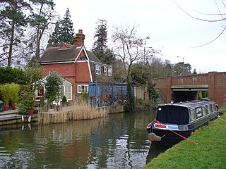
Old Woking is a ward and the original settlement of the town and borough of Woking, Surrey, about 1.3 miles (2.1 km) southeast of the modern town centre. It is bounded by the Hoe Stream to the north and the River Wey to the south and between Kingfield to the west and farmland to the east. The village has no dual carriageways or motorways, its main road is the A247, which connects Woking with Clandon Park and provides access to the A3. The village contains parts of Woking's two largest parks and two converted paper mills. The expanded village largely consists of semi-detached houses with gardens and covers an area of 224 hectares

Richard Onslow, 3rd Baron Onslow

Richard Onslow, 3rd Baron Onslow KB was a British peer and politician, styled Hon. Richard Onslow from 1717 to 1740.

Coleshill, Oxfordshire Human settlement in England

Coleshill is a village and civil parish in the Vale of White Horse district of Oxfordshire, England. Coleshill was part of Berkshire until the 1974 boundary changes transferred it to Oxfordshire. The village is beside the River Cole, which forms both the western boundary of the parish and also the county boundary with Wiltshire. Coleshill is about 3 miles (5 km) west of the market town of Faringdon, about 2 miles (3 km) east of the Wiltshire town of Highworth. The village is on the B4019 road that links the two towns. The 2011 Census recorded the population of the parish as 156.

The Manor of Papworth is located in the parish of Send with Ripley, Surrey, England. It has also been known historically as the Manor of Papeworth, Paperworth, Paperworth Court, and Papeworth Cross, among other names. Its history is intricately connected with that of the manors of Send, Dedswell, and West Clandon.

The Manor of Dedswell is located in the parish of Send with Ripley, Surrey, England. It has also been known historically as the Manor of Dodswell, Dadswell, and Dadswell Court. Its history is intricately connected with that of the manors of Send, Papworth, and West Clandon.

References