
Surrey is a county in South East England which borders Kent to the east, East Sussex to the southeast, West Sussex to the south, Hampshire to the west, Berkshire to the northwest, and Greater London to the northeast. With about 1.2 million people, Surrey is the 12th-most populous English county, the third-most populous home county, after Kent and Essex, and the third-most populous in the Southeast, after Hampshire and Kent.

Guildford is a town in Surrey, England. It lies 28 miles (45 km) southwest of London on the A3 trunk road between the capital and Portsmouth. As of the 2011 census, the town has a population of about 80,000 and is the seat of the wider Borough of Guildford which had an estimated 147,889 inhabitants in 2018.

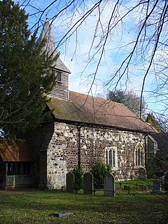
Shackleford is a village and civil parish in the Borough of Guildford, Surrey, England centred to the west of the A3 between Guildford and Petersfield 32 miles (51 km) southwest of London and 5.2 miles (8.4 km) southwest of Guildford. Shackleford includes the localities of Eashing, Hurtmore, Norney and Gatwick.
Bisley is a village and civil parish in the Borough of Surrey Heath in Surrey, England, approximately 25 miles (40 km) southwest of central London. It is midway between Woking and Camberley. The village had a population of 3,965 in the 2011 Census.

Alfold is a village and civil parish in Surrey, England on the West Sussex border. Alfold is a dispersed or polyfocal village in the Green Belt, which is buffered from all other settlements. The Greensand Way runs north of the village along the Greensand Ridge and two named localities exist to the north and south of the historic village centre which features pubs, a set of stocks and a whipping post.
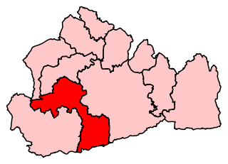
Guildford is a constituency in Surrey represented in the House of Commons of the UK Parliament since 2019 by Angela Richardson, a Conservative.
Burpham is a suburb of Guildford, a town in Surrey, England with an historic village centre. It includes George Abbot School, a parade of small shops, and the nationally recognised Sutherland Memorial Park.

Ash is a village and civil parish in the far west of the borough of Guildford, Surrey. Ash is on the eastern side of the River Blackwater, with a station on the Reading-Guildford-Gatwick line, and direct roads to Aldershot, Farnham and Guildford. The 2011 census counted the residents of the main ward of Ash, which excludes Ash Vale, as 6,120. It is within the Aldershot Urban Area and adjoins the riverside in the east of that large town; Ash has a small museum in the local cemetery chapel, a large secondary school and a library.
King's College Guildford is an academy comprising a secondary school in Guildford, Surrey, England. It has around 500 pupils.

Worplesdon is a village 3.1 miles (5.0 km) NNW of Guildford in Surrey, England and a large dispersed civil parish that includes the settlements of: Worplesdon itself, Fairlands, Jacobs Well, Rydeshill and Wood Street Village, all various-sized smaller settlements, well-connected by footpaths and local roads. Its area includes Whitmoor Common, which can be a collective term for all of its commons.

Normandy is a civil parish of 16.37 square kilometres in the borough of Guildford in Surrey, England and the name of the largest village in that parish. Almost surrounded by its hill ranges, Normandy is in the plain west of Guildford, straddles the A323 'Aldershot Road' and is north of the narrowest part the North Downs known as the Hog's Back which carries a dual carriageway. The parish in 2011 had a population of 2,981 living in 1,310 households, has woods, a public common and four government-operated commons to the north that are an SSSI heath. Normandy has been home to a number of notable residents, including William Cobbett.

Wanborough is a rural village and civil parish in Surrey approximately 4 miles (6 km) west of Guildford on the northern slopes of the Hog's Back. Wanborough lies between Puttenham and Normandy. Wanborough village grew around and to service Wanborough Manor which is on the site of ancient springs.

Jacobs Well or Jacobswell is a small village in Surrey, England, of 20th century creation, with a population of 1,171. The village forms a northern outskirt of Guildford, in the civil parish of Worplesdon which can be considered the mother village of medieval date to the west. The Stoke Hill part of Stringers Common, Slyfield Industrial Estate and a Surrey County Council general waste transfer station to the south form the narrowest of its buffer zones to all sides, separating the Slyfield part of Guildford from the village.

West Surrey was a parliamentary constituency in the county of Surrey, which returned two Members of Parliament (MPs) to the House of Commons of the Parliament of the United Kingdom, elected by the bloc vote system.

Chelsham is a village in the civil parish of Chelsham and Farleigh and the Tandridge District of Surrey, England. It is located in the Metropolitan Green Belt, 15.3 miles (24.6 km) from London, 3 miles (4.8 km) from Oxted and 23.8 miles (38.3 km) from Guildford.
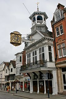
The Guildford Guildhall is a Guildhall located on the High Street of the town of Guildford, Surrey. It is a Grade I listed building.

Wanborough Manor is an Elizabethan manor house on the Hog's Back in Wanborough in the Borough of Guildford, Surrey. During World War II the manor house was requisitioned by the Special Operations Executive (SOE) to train secret agents and was known as Special Training School 5 and later returned to private ownership.
Thomas Dalmahoy was an English politician as the (co-)Member of Parliament for Guildford, 1664-1679. His left-handed marriage is notable in that he married the widow of his family's patron, killed at the final foray of the English Civil War, the Battle of Worcester, having served as his master of the horse attending to his travel arrangements — the patron was the Duke of Hamilton.


