Nowa Sarzyna is a town in Poland, with 6,187 inhabitants (02.06.2009).
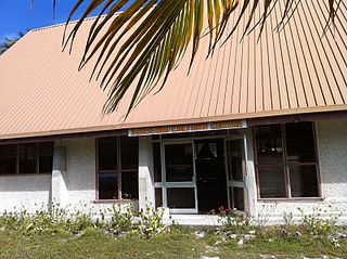
Te Umanibong or the Kiribati Cultural Museum is a museum in Bikenibeu on the atoll of Tarawa in Kiribati. It displays artifacts and other items of cultural and historic significance.
Kierz is a village in the administrative district of Gmina Skępe, within Lipno County, Kuyavian-Pomeranian Voivodeship, in north-central Poland.

Bieniów is a village in the administrative district of Gmina Rejowiec, within Chełm County, Lublin Voivodeship, in eastern Poland. It lies approximately 9 kilometres (6 mi) north-east of Rejowiec, 12 km (7 mi) west of Chełm, and 54 km (34 mi) east of the regional capital Lublin.
Janówek is a village in the administrative district of Gmina Drużbice, within Bełchatów County, Łódź Voivodeship, in central Poland.

Şükürbəyli is a village in the Jabrayil Rayon of Azerbaijan.
Yusifbəyli is a village in the Qubadli Rayon of Azerbaijan.
Bağlıpəyə is a village in the Kalbajar Rayon of Azerbaijan.
Kębło is a village in the administrative district of Gmina Wąwolnica, within Puławy County, Lublin Voivodeship, in eastern Poland.
Parkoszowice is a village in the administrative district of Gmina Miechów, within Miechów County, Lesser Poland Voivodeship, in southern Poland. It lies approximately 5 kilometres (3 mi) south-east of Miechów and 30 km (19 mi) north of the regional capital Kraków.
Bliżów is a village in the administrative district of Gmina Adamów, within Zamość County, Lublin Voivodeship, in eastern Poland. It lies approximately 3 kilometres (2 mi) west of Adamów, 17 km (11 mi) south-west of Zamość, and 82 km (51 mi) south-east of the regional capital Lublin.
Rakówka is a village in the administrative district of Gmina Raków, within Kielce County, Świętokrzyskie Voivodeship, in south-central Poland. It lies approximately 6 kilometres (4 mi) east of Raków and 43 km (27 mi) south-east of the regional capital Kielce.
Ostra Górka is a village in the administrative district of Gmina Krasocin, within Włoszczowa County, Świętokrzyskie Voivodeship, in south-central Poland.
Choszczewka is a village in the administrative district of Gmina Dzierzgowo, within Mława County, Masovian Voivodeship, in east-central Poland.
Andrzejów is a village in the administrative district of Gmina Brochów, within Sochaczew County, Masovian Voivodeship, in east-central Poland.
Poręba is a village in the administrative district of Gmina Jaraczewo, within Jarocin County, Greater Poland Voivodeship, in west-central Poland.

Ryki is a village in the administrative district of Gmina Nowy Dwór Gdański, within Nowy Dwór Gdański County, Pomeranian Voivodeship, in northern Poland. It lies approximately 3 kilometres (2 mi) south of Nowy Dwór Gdański and 37 km (23 mi) south-east of the regional capital Gdańsk.
Nowotna is a village in the administrative district of Gmina Stegna, within Nowy Dwór Gdański County, Pomeranian Voivodeship, in northern Poland. It lies approximately 6 kilometres (4 mi) north of Nowy Dwór Gdański and 34 km (21 mi) east of the regional capital Gdańsk.
Karolewo is a village in the administrative district of Gmina Susz, within Iława County, Warmian-Masurian Voivodeship, in northern Poland. It lies approximately 2 kilometres (1 mi) west of Susz, 22 km (14 mi) north-west of Iława, and 79 km (49 mi) west of the regional capital Olsztyn.
Podławki is a village in the administrative district of Gmina Barciany, within Kętrzyn County, Warmian-Masurian Voivodeship, in northern Poland, close to the border with the Kaliningrad Oblast of Russia. It lies approximately 9 kilometres (6 mi) south of Barciany, 8 km (5 mi) north-west of Kętrzyn, and 67 km (42 mi) north-east of the regional capital Olsztyn.