Related Research Articles

The Potomac River is a major river in the Mid-Atlantic region of the United States that flows from the Potomac Highlands in West Virginia to the Chesapeake Bay in Maryland. It is 405 miles (652 km) long, with a drainage area of 14,700 square miles (38,000 km2), and is the fourth-largest river along the East Coast of the United States and the 21st-largest in the United States. More than 5 million people live within its watershed.

Oktibbeha County is a county in the east central portion of the U.S. state of Mississippi. As of the 2020 census the population was 51,788. The county seat is Starkville. The county's name is derived from a local Native American word meaning either "bloody water" or "icy creek". The Choctaw had long occupied much of this territory prior to European exploration and United States acquisition.
Harrison County is a county located in the U.S. state of Mississippi. As of the 2020 census, the population was 208,621, making it the second-most populous county in Mississippi. Its county seats are Biloxi and Gulfport. The county is named after U.S. President William Henry Harrison.
Bay St. Louis is a city in and the county seat of Hancock County, Mississippi, in the United States. Located on the Gulf Coast on the west side of the Bay of St. Louis, it is part of the Gulfport–Biloxi Metropolitan Statistical Area. The population was 9,284 at the 2020 census, up from 9,260 at the 2010 census.

Gulfport is the 2nd most populous city in the U.S. state of Mississippi after the state capital, Jackson. Along with Biloxi, Gulfport is the co-county seat of Harrison County and the larger of the two principal cities of the Gulfport–Biloxi metropolitan area. As of the 2020 census, the city of Gulfport had a total population of 72,926, with 416,259 residents in its metro area. The city lies along the Gulf Coast in southern Mississippi, taking its name from its port on the Mississippi Sound. It is also home to the U.S. Navy Atlantic Fleet Seabees.

Pass Christian, nicknamed The Pass, is a city in Harrison County, Mississippi, United States. It is part of the Gulfport–Biloxi Metropolitan Statistical Area. The population was 6,307 at the 2019 census.

Laurel is a city in and the second county seat of Jones County, Mississippi, United States. As of the 2020 census, the city had a population of 17,161. Laurel is northeast of Ellisville, the first county seat, which contains the first county courthouse. It has the second county courthouse, as Jones County has two judicial districts. Laurel is the headquarters of the Jones County Sheriff's Department, which administers in the county. Laurel is the principal city of a micropolitan statistical area named for it. Major employers include Howard Industries, Sanderson Farms, Masonite International, Family Health Center, Howse Implement, Thermo-Kool, and South Central Regional Medical Center. Laurel is home to the Lauren Rogers Museum of Art, Mississippi's oldest art museum, established by the family of Lauren Eastman Rogers.

The Pearl River is a river in the U.S. states of Mississippi and Louisiana. It forms in Neshoba County, Mississippi from the confluence of Nanih Waiya and Tallahaga creeks, and has a meander length of 444 miles (715 km). The lower part of the river forms part of the boundary between Mississippi and Louisiana.
The Olentangy River is a 97-mile-long (156 km) tributary of the Scioto River in Ohio, United States.

Mississippi Highway 12 is a state highway in northern Mississippi that runs 198.7 miles (319.8 km) west–east from MS 1 west of Hollandale at the Mississippi River to State Route 18 at the Alabama state line northeast of Columbus. MS 12 traverses three major regions of the state, the Mississippi Delta, the North Central Hills, and the Golden Triangle.
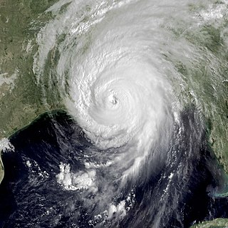
Hurricane Katrina's winds and storm surge reached the Mississippi coastline on the morning of August 29, 2005. beginning a two-day path of destruction through central Mississippi; by 10 a.m. CDT on August 29, 2005, the eye of Katrina began traveling up the entire state, only slowing from hurricane-force winds at Meridian near 7 p.m. and entering Tennessee as a tropical storm. Many coastal towns of Mississippi had already been obliterated, in a single night. Hurricane-force winds reached coastal Mississippi by 2 a.m. and lasted over 17 hours, spawning 11 tornadoes and a 28-foot (8.5 m) storm surge flooding 6–12 miles (9.7–19.3 km) inland. Many, unable to evacuate, survived by climbing to attics or rooftops, or swimming to higher buildings and trees. The worst property damage from Katrina occurred in coastal Mississippi, where all towns flooded over 90% in hours, and waves destroyed many historic buildings, with others gutted to the 3rd story. Afterward, 238 people died in Mississippi, and all counties in Mississippi were declared disaster areas, 49 for full federal assistance. Regulations were changed later for emergency centers and casinos. The emergency command centers were moved higher because all 3 coastal centers flooded at 30 ft (9.1 m) above sea level. Casinos were allowed on land rather than limited to floating casino barges as in 2005.
The Potomac Highlands of West Virginia centers on five West Virginian counties in the upper Potomac River watershed in the western portion of the state's Eastern Panhandle, bordering Maryland and Virginia. Because of geographical proximity, similar topography and landscapes, and shared culture and history, the Potomac Highlands region also includes Pocahontas, Randolph, and Tucker counties, even though they are in the Monongahela River or New River watersheds and not that of the Potomac River.

Mississippi Highway 7 runs generally north–south from the Tennessee state line in Benton County to Belzoni, Mississippi. It travels approximately 168 miles (270 km), serving Humphreys, Leflore, Carroll, Grenada, Yalobusha, Lafayette, Marshall, and Benton counties while serving several points of interest, including Florewood River Plantation State Park, the University of Mississippi, and Wall Doxey State Park. MS 7 runs nearly parallel to the rarely used Mississippi Central Railroad.

The Fairfield Osborn Preserve is a 450-acre nature reserve situated on the northwest flank of Sonoma Mountain in Sonoma County, California. There are eight plant communities within the property, oak woodland being the dominant type. Other communities include chaparral, Douglas fir woodland, native Bunch grass, freshwater marsh, vernal pool, pond and riparian woodland. The flora is extremely diverse including many native trees, shrubs, wildflowers, grasses, lichens and mosses. A diverse fauna inhabits this area including black-tailed deer, coyote, bobcat and an occasional mountain lion; moreover, there are abundant avifauna, amphibians, reptiles and insects.

Interstate 10 (I-10), a major east–west Interstate Highway in the southern areas of the United States, has a section of about 77 miles (124 km) in Mississippi.
A Mississippi Landmark is a building officially nominated by the Mississippi Department of Archives and History and approved by each county's chancery clerk. The Mississippi Landmark designation is the highest form of recognition bestowed on properties by the state of Mississippi, and designated properties are protected from changes that may alter the property's historic character. Currently there are 890 designated landmarks in the state. Mississippi Landmarks are spread out between eighty-one of Mississippi's eighty-two counties; only Issaquena County has no such landmarks.

Ramsey Springs is an unincorporated community in Stone County, Mississippi, United States. It is part of the Gulfport–Biloxi, Mississippi Metropolitan Statistical Area.
The 83rd Indiana Infantry Regiment, sometimes called 83rd Indiana Volunteer Infantry Regiment, was an infantry regiment that served in the Union Army during the American Civil War.
Pat Harrison Waterway District (PHWD) is a Mississippi State Agency with headquarters in Hattiesburg. The agency was created in 1962 with a directive of flood control in southeastern and east central Mississippi.
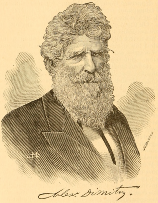
Alexander Dimitry was a mixed race Louisiana Creole. He was the first state superintendent of public instruction in Louisiana, an author, diplomat, educator, journalist, lawyer, orator, and publicist. He spoke eleven languages. He was the first person of color to represent the United States as Ambassador to Costa Rica and Nicaragua. He was also one of the few people of color to serve in the bureaucracy of the Confederate Government. He was the first person of color to attend Georgetown University. Alexander's family passed as white and witnessed countless incidents of racism. Two major incidents involving his family were documented in court entitled Forstall, f.p.c. v. Dimitry (1833) and Pandelly v. Wiltz (1854). Throughout his entire life, Alexander underwent constant persecution and was always reminded of his skin color and ethnic background.
References
- ↑ U.S. Geological Survey Geographic Names Information System: Wolf River (Mississippi)
- ↑ Mary Helen Schaeffer (June 3, 2013). "Short History of Pass Christian 1931" (PDF). Pass Christian, MS: Pass Christian Historical Society. Archived (PDF) from the original on December 7, 2023. Retrieved December 7, 2023.
- ↑ Damrell 1893.
- ↑ Staff Writers (December 7, 2023). "Wolf River" (PDF). Biloxi, MS: Mississippi Gulf Coast National Heritage Area. Archived (PDF) from the original on July 17, 2023. Retrieved December 7, 2023.
- ↑ Williams, Diane (4 March 2014). Mississippi Folk and the Tales They Tell: Myths, Legends and Bald-Faced Lies. The History Press. p. 47. ISBN 978-1-60949-932-7.