The municipality of Au in der Hallertau is located in the north of the district of Freising and in the southern part of the Hallertau, in Bavaria, Germany. Au is famous for its important role in hop planting and hop distribution.

The Hallertau or Holledau is an area in Bavaria, Germany. With an area of 178 km2, it is listed as the largest continuous hop-planting area in the world. According to the International Hop Growing Convention, Germany produces roughly one third of the world's hops, over 80% of which are grown in the Hallertau.
Pfaffenhofen is a Landkreis (district) in Bavaria, Germany. It is bounded by the districts of Eichstätt, Kelheim, Freising, Dachau and Neuburg-Schrobenhausen, and the city of Ingolstadt.
is a Landkreis (district) in the west of Bavaria, Germany with a population of 95,000. Neighbouring districts are Ansbach, Roth, Eichstätt and Donau-Ries. It is located in the south of Middle Franconia, 50 kilometres south of Nuremberg. Largest city and the administrative center is Weißenburg in Bayern.
Solnhofen is a municipality in the district of Weißenburg-Gunzenhausen in the region of Middle Franconia in the Land of Bavaria in Germany. It is in the Altmühl valley.

Hersbruck is a small town in Middle Franconia, Bavaria, Germany, belonging to the district Nürnberger Land. It is best known for the late-gothic artwork of the Hersbruck altar, the "Hirtenmuseum" and the landscape of Hersbruck Switzerland.

Kochel am See is a municipality and a town in the district of Bad Tölz-Wolfratshausen in Bavaria, on the shores of Kochelsee. The municipality consists of the Altjoch, Brunnenbach, Ort, Pessenbach, Pfisterberg, Walchensee and Ried districts.

Regen is a town in Bavaria, Germany, and the district town of the district of Regen.
Kolbermoor is a town in the district of Rosenheim, in Bavaria, Germany.

Immenstadt im Allgäu is a town in Oberallgäu, the southernmost district of Bavaria, Germany, in the German Alps. First mentioned in a 1275 administrative tract, it was granted town privileges in 1360, which makes it one of the oldest towns in the area. It was the seat of the counts of Königsegg-Rothenfels until 1804.

Hilpoltstein is a town in the district of Roth, in Bavaria, Germany. It is situated 10 km southeast of Roth bei Nürnberg and 30 km south of Nuremberg, close to the lake 'Rothsee.

Gräfenberg is a Franconian town in the district of Forchheim, in Bavaria, Germany. It is situated 16km southeast of Forchheim and 25km northeast of Nuremberg.

Heideck is a town with full legal town charter in the district of Roth, in Bavaria, Germany. It is situated in the Metropolitan Area of Nuremberg and at the same time in the Franconian Lake District.

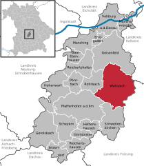
Spalt is a town in the district of Roth, in Bavaria, Germany. It is situated 19 km southwest of Schwabach. Spalt is famous for growing hops for brewing beer.
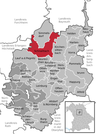
Schnaittach is a market town in Middle Franconia, Bavaria, Germany.

Eckersdorf is a municipality in the district of Bayreuth in Bavaria in Germany.

Nandlstadt is a municipality in the district of Freising in Bavaria in Germany. Nandlstadt is said to be the oldest hop-growing area in the world, having grown them since the year 860. The town lies in a triangle between Freising, Moosburg and Mainburg.

Ruhmannsfelden is a larger municipality in the district of Regen, in Bavaria, Germany.

Babenhausen is a municipality in the district of Unterallgäu in Bavaria, Germany. It is seat of a municipal association with Egg an der Günz, Kettershausen, Kirchhaslach, Oberschönegg and Winterrieden. The view of Babenhausen is dominated by the Fugger Castle, a local attraction with a museum, and the Sankt Andreas Church. It is the seat of the Fuggers, a merchant family from Augsburg which played an important role during the Middle Ages and the Renaissance.

Hohenfels is a municipality in the district of Neumarkt in the region of Upper Palatinate in Bavaria, Germany. The town is host to the United States Army Garrison Hohenfels, which operates the Joint Multinational Readiness Center for training of North Atlantic Treaty Organization (NATO) armed forces.