Woodlawn-Oakdale, Kentucky

Last updated

Farley (formerly Woodlawn-Oakdale), Kentucky
CDP
KYMap-doton-Woodlawn-Oakdale.PNG
Location of Farley (Woodlawn-Oakdale), Kentucky
Coordinates: 37°2′38″N88°34′16″W / 37.04389°N 88.57111°W / 37.04389; -88.57111
Country United States
State Kentucky
County McCracken
Area
  Total5.9 sq mi (15.4 km2)
  Land5.9 sq mi (15.4 km2)
  Water0.0 sq mi (0.0 km2)
Population
 (2000)
  Total4,937
  Density831.8/sq mi (321.2/km2)
Time zone UTC-6 (Central (CST))
  Summer (DST) UTC-5 (CDT)
FIPS code 21-84567

Farley (formerly Woodlawn-Oakdale) is a census-designated place (CDP) in McCracken County, Kentucky, United States. The population was 4,701 at the 2010 census, a decline from 4,937 in 2000. It is part of the Paducah, KY-IL Micropolitan Statistical Area.

Contents

Geography

Farley (Woodlawn-Oakdale) is located at 37°2′38″N88°34′16″W / 37.04389°N 88.57111°W / 37.04389; -88.57111 (37.043786, -88.571223). [1]

According to the United States Census Bureau, the CDP has a total area of 5.9 square miles (15 km2), of which 5.9 square miles (15 km2) is land and 0.17% is water.

Demographics

As of the census [2] of 2000, there were 4,937 people, 2,049 households, and 1,407 families residing in the CDP. The population density was 831.8 inhabitants per square mile (321.2/km2). There were 2,243 housing units at an average density of 377.9 per square mile (145.9/km2). The racial makeup of the CDP was 94.55% White, 2.51% African American, 0.41% Native American, 0.41% Asian, 0.10% Pacific Islander, 0.34% from other races, and 1.68% from two or more races. Hispanic or Latino of any race were 0.87% of the population.

There were 2,049 households, out of which 32.2% had children under the age of 18 living with them, 51.0% were married couples living together, 13.2% had a female householder with no husband present, and 31.3% were non-families. 26.7% of all households were made up of individuals, and 9.7% had someone living alone who was 65 years of age or older. The average household size was 2.41 and the average family size was 2.89.

In the CDP, the population was spread out, with 25.1% under the age of 18, 8.9% from 18 to 24, 30.4% from 25 to 44, 23.5% from 45 to 64, and 12.0% who were 65 years of age or older. The median age was 35 years. For every 100 females, there were 92.6 males. For every 100 females age 18 and over, there were 89.8 males.

The median income for a household in the CDP was $27,313, and the median income for a family was $31,658. Males had a median income of $28,789 versus $17,316 for females. The per capita income for the CDP was $13,344. About 17.6% of families and 21.3% of the population were below the poverty line, including 27.8% of those under age 18 and 14.0% of those age 65 or over.

Related Research Articles

<span class="mw-page-title-main">Kipnuk, Alaska</span> CDP in Alaska, United States

Kipnuk is a census-designated place (CDP) in Bethel Census Area, Alaska, United States. At the 2010 census the population was 639, down from 644 in 2000.

<span class="mw-page-title-main">Rosedale, California</span> Census-designated place in California, United States

Rosedale is a census-designated place (CDP) in Kern County, California, United States. The population was 14,058 at the 2010 census, up from 8,445 at the 2000 census. Formerly a country town 10 miles (16 km) west of Bakersfield, it is now surrounded by suburban housing and currently has the highest household income in Kern County, according to Census estimates.

<span class="mw-page-title-main">East Oakdale, California</span> Census-designated place in California, United States

East Oakdale is an unincorporated census-designated place (CDP) on the Stanislaus River, located east of the city of Oakdale in Stanislaus County, California.

<span class="mw-page-title-main">Riverdale Park, California</span> Census-designated place in California, United States

Riverdale Park is a census-designated place (CDP) in Stanislaus County, California, United States. The population was 1,128 at the 2010 census, up from 1,094 at the 2000 census. It is part of the Modesto Metropolitan Statistical Area.

<span class="mw-page-title-main">Kukuihaele, Hawaii</span> Census-designated place in Hawaii, U.S.

Kukuihaele is a census-designated place (CDP) in Hawaiʻi County, Hawaiʻi, United States. The population was 281 at the 2020 census.

<span class="mw-page-title-main">Paauilo, Hawaii</span> Census-designated place in Hawaii, U.S.

Pa'auilo is a census-designated place (CDP) in Hawaiʻi County, Hawaii, United States. The population was 618 at the 2020 census.

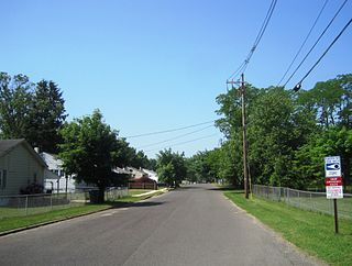
Reidland is an unincorporated community and census-designated place (CDP) in McCracken County, Kentucky, United States. The population was 4,526 at the 2020 census. It is part of the Paducah, KY-IL Micropolitan Statistical Area.

<span class="mw-page-title-main">Inniswold, Louisiana</span> Census-designated place in Louisiana, United States

Inniswold is an unincorporated area and census-designated place (CDP) in East Baton Rouge Parish, Louisiana, United States. The population was 6,180 at the 2010 census, up from 4,944 in 2000. In 2020, its population was 5,987. It is part of the Baton Rouge metropolitan statistical area.

<span class="mw-page-title-main">Oak Hills Place, Louisiana</span> Census-designated place in Louisiana, United States

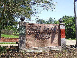
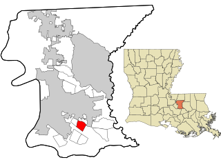
Oak Hills Place is a census-designated place (CDP) in East Baton Rouge Parish, Louisiana, United States. The population was 8,195 at the 2010 census. It is part of the Baton Rouge Metropolitan Statistical Area, and one of the most affluent suburbs of Baton Rouge.

<span class="mw-page-title-main">Village St. George, Louisiana</span> Census-designated place in Louisiana, United States

Village St. George is a census-designated place (CDP) in East Baton Rouge Parish, Louisiana, United States. The population was 7,104 at the 2010 census. It is part of the Baton Rouge Metropolitan Statistical Area.

<span class="mw-page-title-main">Maugansville, Maryland</span> CDP in Maryland, United States

Maugansville is a census-designated place (CDP) in Washington County, Maryland, United States. The population was 2,295 at the 2000 census.

<span class="mw-page-title-main">Helena Valley Northwest, Montana</span> CDP in Montana, United States

Helena Valley Northwest is a census-designated place (CDP) in Lewis and Clark County, Montana, United States. The population was 3,482 at the 2010 census. It is part of the Helena Micropolitan Statistical Area.

<span class="mw-page-title-main">Pemberton Heights, New Jersey</span> Populated place in Burlington County, New Jersey, US

Pemberton Heights is an unincorporated community and census-designated place (CDP) located within Pemberton Township, in Burlington County, in the U.S. state of New Jersey. As of the 2010 United States Census, the CDP's population was 2,423.

<span class="mw-page-title-main">Fairview, Dutchess County, New York</span> Census-designated place in New York, United States

Fairview is a hamlet and census-designated place (CDP) in Dutchess County, New York, United States. The population was 5,515 at the 2010 census. It is part of the Poughkeepsie–Newburgh–Middletown, NY Metropolitan Statistical Area as well as the larger New York–Newark–Bridgeport, NY-NJ-CT-PA Combined Statistical Area.

<span class="mw-page-title-main">Woodlawn, North Carolina</span> Census-designated place in North Carolina, United States

Woodlawn is a census-designated place in Alamance County, North Carolina, United States.

<span class="mw-page-title-main">Valley Hill, North Carolina</span> Census-designated place in North Carolina, United States

Valley Hill is an unincorporated community and census-designated place (CDP) in Henderson County, North Carolina, United States. The population was 2,070 at the 2010 census. It is part of the Asheville Metropolitan Statistical Area.

<span class="mw-page-title-main">West Lake Sammamish, Bellevue, Washington</span> Neighborhood in King, Washington, United States

West Lake Sammamish was a census-designated place (CDP) in King County, Washington, United States. The population was 5,937 at the 2000 census. The census area was annexed by Bellevue in 2001.

<span class="mw-page-title-main">Coal City, West Virginia</span> Census-designated place in West Virginia, United States

Coal City is a census-designated place (CDP) in Raleigh County, West Virginia, United States. The population was 1,815 at the 2010 census. Coal City's population is composed of other surrounding unincorporated communities.

<span class="mw-page-title-main">Van Buren (CDP), Maine</span> Census-designated place in Maine, United States

Van Buren is a census-designated place (CDP) comprising the main village within the town of Van Buren in Aroostook County, Maine, United States. The population of the CDP was 1,937 at the 2010 census, out of a population of 2,171 for the entire town.

<span class="mw-page-title-main">Farley, Kentucky</span> Census-designated place in Kentucky, United States

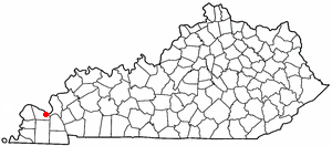
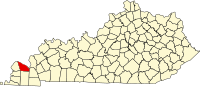
Farley is a census-designated place (CDP) in McCracken County, Kentucky, United States. The population was 4,374 as of the 2020 census, down from 4,701 in 2010. It is part of the Paducah, KY-IL Micropolitan Statistical Area. The area was listed by the U.S. Census Bureau as Woodlawn-Oakdale starting with the 1980 census and as Farley starting with the 2010 census.

References

  1. "US Gazetteer files: 2010, 2000, and 1990". United States Census Bureau. February 12, 2011. Retrieved April 23, 2011.
  2. "U.S. Census website". United States Census Bureau . Retrieved January 31, 2008.