
Sool is a disputed administrative region (gobol). It borders Togdheer to the west, Sanaag to the north, Ethiopia to the south and Nugal, Bari to the east. Its capital city is Las Anod. The region is disputed by the self-declared Republic of Somaliland and SSC-Khatumo. The region is partially controlled by both polities.

Marodi Jeh is an administrative region (gobol) in western Somaliland. It is the most populous region of the country. It is bordered by Awdal to the west, Sahil to the north, Togdheer to the east and Ethiopia to the south. Marodi Jeh was created by splitting the previously existing region (gobolka). In 2007 the region of Woqooyi Galbeed was renamed to Maroodi Jeex.

Bari is an administrative region (gobol) in northeastern Somalia that consists of six districts: Qandala, Iskushuban, Aluula, Bosaso, Bandarbeyla, and Qardho. The port city of Bosaso is the capital of the region and the largest city in Bari. The region is part of the autonomous Somali state of Puntland.

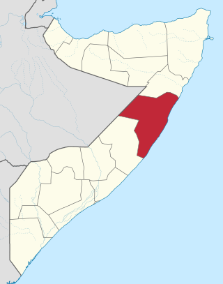
Nugal, traditionally known as Nugaaleed-Bari or Bari-Nugaal meaning eastern Nugaal, or Nugaal xaggeeda hoose meaning lower Nugaal, is an administrative region (gobol) in northern Somalia.
Mudug is an administrative region (gobol) in north-central Somalia. The population of Mudug is 131,455 as of 2005.

Galguduud is an administrative region (gobol) of Galmudug state in central Somalia. Its administrative capital is Dusmareb. The largest town in the region is El Buur, which lies at the centre of the region.

Bakool is a region (gobol) in southwestern Somalia.

Middle Shabelle is an administrative region (gobol) in southern Somalia.

Lower Shabelle is an administrative region (gobol) in southern Somalia.

Banaadir is an administrative region (gobol) in southeastern Somalia. It covers the same area as the city of Mogadishu, which serves as the capital. It is the only region in the country not belonging to any of the six states. It is bordered to the northwest by the Shabelle river, and to the southeast by the Indian Ocean. Although by far the smallest administrative region in Somalia, it has the largest population, estimated at 1,650,227 in 2014.

Bay is an administrative region (gobol) in southern Somalia.
Gedo is an administrative region (gobol) in Jubaland, southern Somalia. Its regional capital is Garbahaarreey. The region was formed during 1974 and is bordered by the Ogaden in Ethiopia, the North Eastern Province in Kenya, and the Somali regions of Bakool, Bay, Jubbada Dhexe, and Jubbada Hoose further down east. The southern parts of Gedo, west of the Jubba River, used to be part of the old British Trans-Juba region during half of the seventy years of colonial era in Africa from 1890 to 1960. The British and Italians fought twice over this area.

Middle Juba is an administrative region (gobol) in southern Somalia. With its capital at Bu'aale, it is located in the autonomous Jubaland region.

Lower Juba is an administrative region (gobol) in southern Somalia. With its capital at Kismayo, it lies in the autonomous Jubaland region.

The Human Development Index (HDI) is a statistical composite index of life expectancy, education, and per capita income indicators, which is used to rank countries into four tiers of human development. A country scores a higher level of HDI when the lifespan is higher, the education level is higher, and the gross national income GNI (PPP) per capita is higher. It was developed by Pakistani economist Mahbub ul-Haq and was further used to measure a country's development by the United Nations Development Programme (UNDP)'s Human Development Report Office.

According to Article 168 of the Constitution of Costa Rica, the political divisions are officially classified into 3 tiers of sub-national entities.

Pemba South Region or South Pemba Region is one of the 31 regions of Tanzania, covering an area of 332 km2 (128 sq mi). The region is comparable in size to the combined land area of the nation state of Grenada. and the administrative region is located entirely on Pemba island. Pemba South Region is bordered to the south by Indian Ocean, north by Pemba North Region and the west by Pemba channel. The regional capital is Mkoani.. The region has the fifth highest HDI in the country, making one of the most developed regions in the country. The region has the highest standard of living on Pemba Island. According to the 2022 census, the region has a total population of 271,350.

Unguja North Region, Zanzibar North Region or North Zanzibar Region is one of the 31 regions of Tanzania. The region covers an area of 407 km2 (157 sq mi). The region is comparable in size to the combined land area of the nation state of Andorra. and the administrative region is located entirely on the island of Zanzibar. Unguja North Region is bordered on three sides to the north by Indian Ocean, southeast by Unguja South Region and southwest by Mjini Magharibi Region. The regional capital is the town of Mkokotoni. The region has the fifth highest HDI in the country, making one of the most developed regions in the country. According to the 2012 census, the region has a total population of 187, 455. Zanzibar North is divided into two districts, Kaskazini A and Kaskazini B.

Somalia is officially divided into 18 administrative regions. These are in turn subdivided into seventy-two districts

The following outline is provided as an overview and topical guide to Gabon :
