Christchurch is the largest city in the South Island and the second-largest city by urban area population in New Zealand. Christchurch has an urban population of 415,100, and a metropolitan population of over half a million. It is located in the Canterbury Region, near the centre of the east coast of the South Island, east of the Canterbury Plains. It is located near the southern end of Pegasus Bay, and is bounded to the east by the Pacific Ocean and to the south by the ancient volcanic complex of the Banks Peninsula. The Avon River (Ōtākaro) winds through the centre of the city, with a large urban park along its banks. With the exception of the Port Hills, it is a relatively flat city, on an average around 20 m (66 ft) above sea level. Christchurch has a reputation for being an English city, with its architectural identity and nickname the 'Garden City' due to similarities with garden cities in England, but also has a historic Māori heritage. Christchurch has a temperate oceanic climate with regular moderate rainfall.

Cathedral Square, locally known simply as the Square, is the geographical centre and heart of Christchurch, New Zealand, where the city's Anglican cathedral, ChristChurch Cathedral is located. The square stands at the theoretical crossing of the city's two main orthogonal streets, Colombo Street and Worcester Street, though in practice both have been either blocked off or detoured around the square itself. The square was badly damaged in the February 2011 Christchurch earthquake.

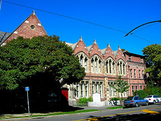
TheArts Centre Te Matatiki Toi Ora is a hub for arts, culture, education, creativity and entrepreneurship in Christchurch, New Zealand. It is located in the Gothic Revival former Canterbury College, Christchurch Boys' High School and Christchurch Girls' High School buildings, many of which were designed by Benjamin Mountfort. The centre is a national landmark and taonga as it is home to New Zealand's largest collection of category one heritage buildings with 21 of the 23 buildings covered by Heritage New Zealand listings.

Rolleston is the seat and largest town in the Selwyn District, in the Canterbury region of New Zealand's South Island. It is located on the Canterbury Plains 22 kilometres (14 mi) south-west of Christchurch, and is part of the wider Christchurch metropolitan area.
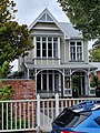
Linwood is an inner suburb of the city of Christchurch, New Zealand. It lies to the east of the city centre, mostly between Ferry Road and Linwood Avenue, two of the major arterial roads to the eastern suburbs of Christchurch. It is one of the city's older suburbs, established in 1850.

Christchurch City Libraries is a network of 21 libraries and a mobile book bus. operated by the Christchurch City Council and Following the 2011 Christchurch earthquake the previous Christchurch Central Library building was demolished, and was replaced by a new central library building in Cathedral Square, Tūranga, which opened in 2018. A number of community libraries were also rebuilt post earthquake.

Christchurch Central City or Christchurch City Centre is the geographical centre and the heart of Christchurch, New Zealand. It is defined as the area within the Four Avenues and thus includes the densely built up central city, some less dense surrounding areas of residential, educational and industrial usage, and green space including Hagley Park, the Christchurch Botanic Gardens and the Barbadoes Street Cemetery.
Christchurch tramway routes have developed from lines that were first established by a troika of private tramway companies in the latter part of the 19th century, through to a significantly expanded system under the municipal Christchurch Tramway Board, to the City Council-built heritage circuit. These routes have been worked by all three main forms of tramway motive power and have significantly contributed to the development of Christchurch City in New Zealand's South Island.
Our City, more formally Our City O-Tautahi, also known as the Old Municipal Chambers, is a Queen Anne style building on the corner of Worcester Street and Oxford Terrace in the Christchurch Central City. It is a Category I heritage building registered with Heritage New Zealand. From 1887 to 1924 it was used by Christchurch City Council as their civic offices, providing room for meetings of the council and for housing staff, before they moved to the Civic. It was then used for many decades by the Canterbury Chamber of Commerce and served as the main tourist information. It was last used as an exhibition and events centre before being damaged in the Christchurch earthquakes. It is due to be reopened in June 2024.
The Cranmer Centre was a historic building in Christchurch, New Zealand. Its original use, until 1986, was as the Christchurch Girls' High School, the second high school for girls in the country. Registered with the New Zealand Historic Places Trust as a Category I heritage building, it was purchased by Arts Centre of Christchurch Trust in 2001, and demolished in May 2011 following the February 2011 Christchurch earthquake.

The Dux de Lux, originally called Llanmaes, was a popular beer garden and restaurant in Christchurch, New Zealand, that was part of the Arts Centre.

Clarendon Tower was a high rise building on Worcester Street at Oxford Terrace in the Christchurch Central City, New Zealand. Built on the site of the former Clarendon Hotel, the façade of the historic building was kept in the redevelopment and was protected by the New Zealand Historic Places Trust as a Category II heritage structure. Following damage from the February 2011 Christchurch earthquake, the 17-storey building has been demolished.
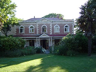
Linwood House was built as the homestead for Joseph Brittan, who, as surgeon, newspaper editor and provincial councillor, was one of the dominant figures in early Christchurch, New Zealand. The suburb of Linwood was named after Brittan's farm and homestead. Brittan's daughter Mary married William Rolleston, and they lived at Linwood House following Joseph Brittan's death. During that time, Rolleston was the 4th Superintendent of the Canterbury Province, and Linwood House served for many important political and public functions.

City Mall is the main pedestrian mall in the central city of Christchurch, New Zealand, comprising two sections of Cashel Street plus the Bridge of Remembrance and one section of High Street. It is also known colloquially as Cashel Mall. The Bridge of Remembrance was pedestrianised in 1976. The main mall was closed to traffic on 11 January 1982 and formally reopened as a pedestrian mall on 7 August, but it was not until 1992 that the entire mall was paved. The mall was redeveloped between 2006 and 2009, and track was installed for an expansion of the heritage tram network.

TheTrinity Church or Trinity Congregational Church designed by Benjamin Mountfort, later called the State Trinity Centre, is a Category I heritage building listed with Heritage New Zealand. Damaged in the 2010 Canterbury earthquake and red-stickered after the February 2011 Christchurch earthquake, the building was threatened with demolition like most other central city heritage buildings. In June 2012, it was announced that the building would be saved, repaired and earthquake strengthened. The building, post its church status, has housed some commercial operations, including the State Trinity Centre; 'The Octagon' (2006–2010); and later, following earthquake repairs, a business called 'The Church Brew Pub' (2023–present).

New Regent Street is a pedestrian mall in Christchurch. Built as a private development in the early 1930s with 40 shops in Spanish Mission architectural style, it is one of the city's major tourist attractions. Providing a number of small shops as a comprehensive development was an advanced idea at the time, and New Regent Street is regarded as a forerunner to modern shopping malls. Due to its coherent architectural character, the buildings in the streets are listed as Category I heritage items by Heritage New Zealand, and in addition, the entire street has a historic area listing. The street was pedestrianised in 1994 in preparation for the introduction of the Christchurch heritage tram, which began operation in February 1995. Damaged in the February 2011 Christchurch earthquake, the street and buildings reopened in April 2013, and the tram returned from November of that year. Following the 2016 Valentine's Day earthquake, five of the buildings that had not been repaired after the previous earthquakes had been cordoned off, which stopped the tram from operating on its original heritage loop until May.
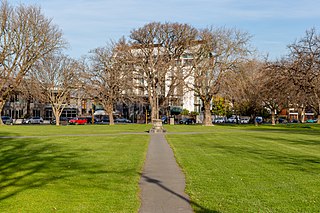
Latimer Square is an urban park in central Christchurch, New Zealand. It is located 400 metres (440 yd) east of the city's centre, Cathedral Square. Many commemorative events take place in Latimer Square. The square lies between the major urban thoroughfares of Gloucester Street and Worcester Street. Madras Street runs north and south to Latimer Square. The square is grassed and crossed by concrete paths and edged by mature trees. It covers an area of a little over 1.8 hectares.

Gloucester Street is a major urban street in central Christchurch in the South Island of New Zealand. It runs for approximately 4.9 kilometres (3.0 mi) from a junction with Rolleston Avenue at its western end, directly opposite Christ's College, to the suburbs of Linwood and Avonside in the east. For the majority of its length it runs due west-east, with the section from the central city's eastern edge to Linwood veering to the northeast.