Wordie Bay (Greenland)

Last updated
Wordie Bay
Wordie Bugt
Greenland edcp relief location map.jpg
Red pog.svg
Wordie Bay
Location in Greenland
Location Arctic
Coordinates 74°3.7′N22°20.09′W / 74.0617°N 22.33483°W / 74.0617; -22.33483
Ocean/sea sources Godthab Gulf
Gael Hamke Bay
Greenland Sea
Basin  countries Greenland
Max. length7 kilometres (4.3 mi)
Max. width5 kilometres (3.1 mi)

Wordie Bay (Danish : Wordie Bugt) is a bay in eastern Greenland. Administratively it is part of the Northeast Greenland National Park zone.

Contents

History

The bay appeared as "Wordiebukta" on the 1932 Norwegian Svalbard and Arctic Ocean Survey Norges Svalbard og Ishavsundersøkelser (NSIU) map. Like the glacier at its head, it was named after Scottish polar explorer James Wordie (1889–1962). [1]

Geography

Wordie Bay is a section of fjord at the head of the Godthab Gulf. It is located at the terminus of the Wordie Glacier, between Stromtangen and Cape Ruth. There are several nunataks rising above the shore. Cape Ruth is at the southeastern end of Jordanhill, a conspicuous 1,410 metres (4,630 ft) high promontory rising by the shore of the bay on the northern side. [2] The bay has a width of about 3 kilometres (1.9 mi) at the head, widening to almost 5 kilometres (3.1 mi) south of Cape Ruth. [3]

Besides the great Wordie Glacier in the west, A. Schmidt Glacier, Nippoldt Glacier and Haussman Glacier are small glaciers flowing north into Wordie Bay from the Norlund Alps. [1] Hudson Land lies to the south and further to the west is Steno Land. [3]

Map of Northeastern Greenland Operational Navigation Chart B-9, 1st edition.jpg
Map of Northeastern Greenland
East Greenland Terra/MODIS satellite image Greenland.A2003233.1340.250m.jpg
East Greenland Terra/MODIS satellite image

Related Research Articles

<span class="mw-page-title-main">Kaiser Franz Joseph Fjord</span> Major fjord system in the NE Greenland National Park area, East Greenland

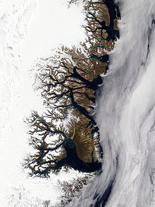
Kaiser Franz Joseph Fjord is a major fjord system in the NE Greenland National Park area, East Greenland.

Drygalski Glacier is a broad glacier, 18 nautical miles long which flows southeast from Herbert Plateau through a rectangular re-entrant to a point immediately north of Sentinel Nunatak on the east coast of Graham Land, Antarctica.

<span class="mw-page-title-main">Gael Hamke Bay</span>

Gael Hamke Bay is a large bay in King Christian X Land, East Greenland. Administratively it is part of the Northeast Greenland National Park zone.

Charcot Bay is a bay about 10 nautical miles wide between Cape Kater and Cape Kjellman along the Davis Coast of Graham Land, Antarctica.

<span class="mw-page-title-main">Wordie Glacier</span> Glacier in Greenland

Wordie Glacier is a glacier in northeastern Greenland. It has its terminus on the east coast of the Greenland ice sheet.

<span class="mw-page-title-main">Dove Bay</span> Bay in King Frederick VIII Land, Greenland

Dove Bay is a bay in King Frederick VIII Land, northeastern Greenland. It is part of the Northeast Greenland National Park area.

<span class="mw-page-title-main">Bliss Bay</span>

Bliss Bay is a bay in the Wandel Sea, Northern Greenland. The area of the bay is uninhabited. Administratively Bliss Bay and its surroundings belong to the Northeast Greenland National Park.

<span class="mw-page-title-main">Constable Bay</span>

Constable Bay is a bay in the Wandel Sea, Northern Greenland. Administratively Constable Bay and its surroundings belong to the Northeast Greenland National Park.

<span class="mw-page-title-main">Nordvestfjord</span> Fjord in Greenland

Nordvestfjord, meaning 'Northwest Fjord', is a fjord in King Christian X Land, eastern Greenland.

<span class="mw-page-title-main">Geologfjord</span>

Geologfjord is a fjord in King Christian X Land, East Greenland. Administratively it belongs to the Northeast Greenland National Park.

Segelsällskapet Fjord is a fjord in King Christian X Land, eastern Greenland.

<span class="mw-page-title-main">Dusen Fjord</span>

Dusen Fjord or Dusén Fjord is a fjord in the NE Greenland National Park area, East Greenland.

Loch Fyne is a fjord in the NE Greenland National Park area, East Greenland.

<span class="mw-page-title-main">Godthab Gulf</span>

Godthab Gulf, also known as Godthaab Golf, Clavering Fjord, Clavering Sound and Inner Bay, is a fjord in King Christian X Land, East Greenland. Administratively it is part of the Northeast Greenland National Park zone.

<span class="mw-page-title-main">Young Sound</span> Sound in Greenland

Young Sound is a marine channel with a fjord structure in King Christian X Land, East Greenland. Administratively it is part of the Northeast Greenland National Park zone.

<span class="mw-page-title-main">Tyrolerfjord</span>

Tyrolerfjord is a fjord in King Christian X Land, East Greenland. Administratively it is part of the Northeast Greenland National Park zone.

<span class="mw-page-title-main">Norlund Alps</span> Mountain range in Greenland

The Norlund Alps are a mountain range in King Christian X Land, East Greenland. Administratively these mountains are part of the Northeast Greenland National Park.

<span class="mw-page-title-main">Grandjean Fjord</span>

Grandjean Fjord is a fjord in King Christian X Land, East Greenland. Administratively it is part of the Northeast Greenland National Park zone.

<span class="mw-page-title-main">Muskox Fjord</span>

Muskox Fjord is a fjord in King Christian X Land, East Greenland. Administratively it lies in the Northeast Greenland National Park area. This fjord is part of the Kaiser Franz Joseph Fjord system.

Kjerulf Fjord is a fjord in King Christian X Land, eastern Greenland.

References

  1. 1 2 "Catalogue of place names in northern East Greenland". Geological Survey of Denmark. Retrieved 20 September 2019.
  2. Prostar Sailing Directions 2005 Greenland and Iceland Enroute, p. 122
  3. 1 2 "Kap Ruth". Mapcarta. Retrieved 20 September 2019.