World Botanical Gardens

Last updated

Coordinates: 19°54′13.7052″N155°8′11.9076″W / 19.903807000°N 155.136641000°W / 19.903807000; -155.136641000

Geographic coordinate system Coordinate system

A geographic coordinate system is a coordinate system that enables every location on Earth to be specified by a set of numbers, letters or symbols. The coordinates are often chosen such that one of the numbers represents a vertical position and two or three of the numbers represent a horizontal position; alternatively, a geographic position may be expressed in a combined three-dimensional Cartesian vector. A common choice of coordinates is latitude, longitude and elevation. To specify a location on a plane requires a map projection.

Contents

World Botanical Gardens Heliconia hilo.JPG
World Botanical Gardens

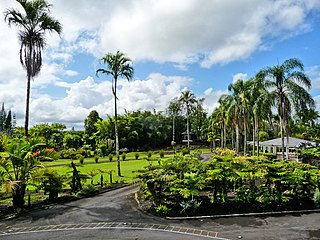
World Botanical Gardens and Waterfalls is a commercial botanical gardens with a large waterfall, located between Umauma and Hakalau, at the corner of Leopolino Road and Hawaii Belt Road, State Highway 19, 16 miles north of Hilo, Island of Hawaiʻi, Hawaii. The gardens are open daily with an admission fee. Major features include Kamaʻeʻe Falls, a 100-foot (30 m) waterfall, the second largest maze in Hawaii known as the Children's Maze, over 10 acres (0.040 km2) of arboretum, and many specialized garden areas.

Botanical garden well-tended area displaying a wide range of plants labelled with their botanical names

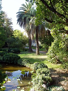
A botanical garden or botanic garden is a garden dedicated to the collection, cultivation, preservation and display of a wide range of plants labelled with their botanical names. It may contain specialist plant collections such as cacti and other succulent plants, herb gardens, plants from particular parts of the world, and so on; there may be greenhouses, shadehouses, again with special collections such as tropical plants, alpine plants, or other exotic plants. Visitor services at a botanical garden might include tours, educational displays, art exhibitions, book rooms, open-air theatrical and musical performances, and other entertainment.

Waterfall Place where water flows over a vertical drop in the course of a river

A waterfall is an area where water flows over a vertical drop or a series of steep drops in the course of a stream or river. Waterfalls also occur where meltwater drops over the edge of a tabular iceberg or ice shelf.

Hawaii Belt Road highway in Hawaii

The Hawaiʻi Belt Road is a modern name for the Māmalahoa Highway and consists of Hawaiʻi state Routes 11, 19, and 190 that encircle the Island of Hawaiʻi. The southern section, between Hilo and Kailua-Kona is numbered as Route 11. The section between Hilo and Waimea is Route 19. Between Waimea and Kailua-Kona, the road is split in two: the original "mauka" route and a "makai" Route 19, completed in 1975, which serves as access to the Kona and Kohala Coast resorts. In the Hawaiian language, mauka means "towards the mountain" and makai means "towards the sea". These terms are commonly used in travel directions.

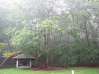
The gardens were founded in 1995 by Walter L. Wagner on 300 acres (1.2 km2) of agricultural land bordered by the Umauma River and extending up Mauna Kea's slope. The Rainforest Walk was the first portion open to public touring on July 4, 1995. [1]

Agricultural land land used for agricultural purposes

Agricultural land is typically land devoted to agriculture, the systematic and controlled use of other forms of life—particularly the rearing of livestock and production of crops—to produce food for humans. It is thus generally synonymous with both farmland or cropland, as well as pasture or rangeland.

Mauna Kea Hawaiian volcano

Mauna Kea is a dormant volcano on the island of Hawaii. Its peak is 4,207.3 m (13,803 ft) above sea level, making it the highest point in the state of Hawaii. Most of the mountain is under water, and when measured from its oceanic base, Mauna Kea is the tallest mountain in the world measuring over 10,000 m (33,000 ft). Mauna Kea is about a million years old, and has thus passed the most active shield stage of life hundreds of thousands of years ago. In its current post-shield state, its lava is more viscous, resulting in a steeper profile. Late volcanism has also given it a much rougher appearance than its neighboring volcanoes due to construction of cinder cones, decentralization of its rift zones, glaciation on its peak, and weathering by the prevailing trade winds. Mauna Kea last erupted 6,000 to 4,000 years ago and is now considered dormant. The peak is about 38 m (125 ft) higher than Mauna Loa, its more massive neighbor.

Rainforest type of forest with high rainfall

Rainforests are forests characterized by high rainfall, with annual rainfall in the case of tropical rainforests between 250 and 450 centimetres, and definitions varying by region for temperate rainforests. The monsoon trough, alternatively known as the intertropical convergence zone, plays a significant role in creating the climatic conditions necessary for the Earth's tropical rainforests.

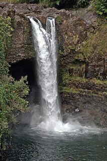
On September 2, 2004, a change of management of World Botanical Gardens took place, and in 2008 the Umauma Falls overlook and its surrounding 90 acres was sold to Umauma Experience. [2]

The Umauma Falls are located on the Umauma River on the Big Island of Hawaii, approximately 16 miles north of Hilo.

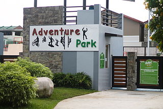
In 2009 the garden officially opened [3] a zip-line tour known as Zip Isle Zip Line Adventure descending into the Hanapueo stream gulch. This was to become one of many adventures that would initiate the collection known as Botanical World Adventures. The adventures include World Botanical Gardens, Zip Isle Zip Line and in 2011 the addition or Segway Off-Road Rainforest Adventure.

Stream A body of surface water flowing down a channel

A stream is a body of water with surface water flowing within the bed and banks of a channel. The stream encompasses surface and groundwater fluxes that respond to geological, geomorphological, hydrological and biotic controls.

Gulch Deep V-shaped valley formed by erosion

In xeric lands, a gulch is a deep V-shaped valley formed by erosion. It may contain a small stream or dry creek bed and is usually larger in size than a gully. Sudden intense rainfall upstream may produce flash floods in the bed of the gulch.

See also

Related Research Articles

Hawaii (island) Largest of the Hawaiian islands

Hawaiʻi is the largest island located in the U.S. state of Hawaii. It is the largest and the southeasternmost of the Hawaiian Islands, a chain of volcanic islands in the North Pacific Ocean. With an area of 4,028 square miles (10,430 km2), it has 63% of the Hawaiian archipelago's combined landmass, and is the largest island in the United States. However, it has only 13% of Hawaiʻi's people. The island of Hawaiʻi is the third largest island in Polynesia, behind the two main islands of New Zealand.

Hawaiian Ocean View, Hawaii Census-designated place in Hawaii, United States

Hawaiian Ocean View is a census-designated place (CDP) in Hawaiʻi County, Hawaiʻi, United States located in the District of Kaʻū. It includes the subdivisions of Hawaiian Ocean View Estates (HOVE), Hawaiian Ocean View Ranchos, Kahuku Country Gardens, Kula Kai View Estates, Kona Gardens, Keone's Ranchos, and Kona View Estates. The population was 4,437 at the 2010 census, up from 2,178 at the 2000 census.

Hilo, Hawaii Census-designated place in Hawaii, United States

Hilo is the largest town and census-designated place (CDP) in Hawaii County, Hawaii, United States, which encompasses the Island of Hawaiʻi. The population was 43,263 at the 2010 census.

Hawaii Route 200 highway in Hawaii

Route 200, known locally as Saddle Road, traverses the width of the Island of Hawaiʻi, from downtown Hilo to its junction with Hawaii Route 190 near Waimea. The road was once considered one of the most dangerous paved roads in the state, with many one-lane bridges and areas of marginally maintained pavement. Most of the road has now been repaved, and major parts have new re-alignments to modern standards. The highway is mostly one-lane in each direction, but there are two lanes on the uphill portions. The highway reaches a maximum elevation of 6,632 feet (2,021 m) and is subject to fog and low visibility. Many rental car companies used to prohibit use of their cars on Saddle Road, but now allow use of the road. The highway experiences heavy use as it provides the shortest driving route from Hilo to Kailua-Kona and access to the slopes of Mauna Loa and the Mauna Kea Observatories.

Hakalau, Hawaii unincorporated community in Hawaii

Hakalau is a small unincorporated community located along the Hamakua coast about 15 miles (24 km) north of Hilo on the Big Island of Hawaii in the U.S. state of Hawaii at 19°53′49″N155°7′35″W.

Hamakua

Hāmākua is a district on the northeast coast of Hawaiʻi's Big Island, administered by the County of Hawaiʻi in the state of Hawaiʻi. It is also the name given for the coastline in the region, the "Hāmākua Coast".

Liliuokalani Park and Gardens

Liliʻuokalani Park and Gardens is a 24.14-acre (97,700 m2) park with Japanese gardens, located on Banyan Drive in Hilo on the island of Hawaiʻi.

Hilo Tropical Gardens, located at 1477 Kalanianaole Avenue, Hilo, Hawaii, Hawaii was a privately run botanical garden with a guest house for budget travelers.

Hawaii Tropical Botanical Garden

The Hawaii Tropical Botanical Garden is a nonprofit botanical garden and nature preserve located on the 4 mile scenic route off of Route 19 at 27-717 Old Māmalahoa Highway, Pāpa'ikou, Hawaii (island), Hawaii. It is open daily except Thanksgiving, Christmas, and New Year's Day. An admission fee is charged to the general public, those with a military I.D. are admitted free of charge.

The University of Hawaiʻi at Hilo Botanical Gardens are botanical gardens on the University of Hawaiʻi at Hilo campus, located at 200 West Kawili Street, Hilo, Hawaiʻi on the island of Hawaiʻi. They are open daily without charge.

Pua Mau Place Arboretum and Botanical Garden is an early-stage, nonprofit arboretum and botanical garden located off Highway 270 at 10 Ala Kahua, Kawaihae, on the dry slopes of the Kohala Mountain Range on Hawaii (island), Hawaii. It is open daily with an admission fee.

Nani Mau Gardens

Nani Mau Gardens are commercial botanical gardens located at 421 Makalika Street, Hilo, Hawaiʻi on the island of Hawaiʻi, coordinates 19°40′20″N155°3′17″W. They are open daily, and an admission fee is charged. The gardens' name, Nani Mau, means "forever beautiful". They were established by Makato Nitahara and opened to the public in 1972.

Rainbow Falls (Hawaii) Waterfall in Hawaii

Rainbow (Waiānuenue) Falls is a waterfall located in Hilo, Hawaii. It is 80 ft (24 m) tall and almost 100 ft (30 m) in diameter. The falls are part of the Hawai'i State Parks. There is no fee to see the falls.

Kalopa State Recreation Area state park in Hawaiʻi

The Kalōpā Native Forest State Park and Recreation Area is a state park with an arboretum of native trees located approximately 40 mi (64 km) northwest of Hilo, near the village of Honokaʻa, a few miles inland from the Mamalahoa Highway section of the Hawaii Belt Road, Island of Hawaiʻi, Hawaiʻi.

Kolekole Beach Park

Kolekole Beach Park is a Hawaii county park on the island of Hawaii. As of April 2017, it is currently closed due to lead contamination found in the soil of the lawn areas. It will remain closed as further testing is done.

Animal theme park

An animal theme park, also known as a zoological theme park, is a combination of a theme park and a zoological park, mainly for entertainment, amusement, and commercial purposes. Many animal theme parks combine classic theme park elements, such as themed entertainment and amusement rides, with classic zoo elements such as live animals confined within enclosures for display. Many times, live animals are utilized and featured as part of amusement rides and attractions found at animal theme parks.

Pasig Rainforest Park

Pasig Rainforest Park, also known as Pasig City Rainforest Adventure Experience and Pasig Central Park, is a public park in Pasig, eastern Metro Manila, Philippines. It spans 8 hectares, and is a mixed recreational and natural park with a mini-zoo. The rainforest park was opened to the public in 1977 with an initial area of 4.8 hectares. It had an Olympic-sized swimming pool, jogging oval, children's playground, tennis courts and a fitness center. In 1996, the park was enlarged with the acquisition of an additional 2.1 hectares. The park was relaunched as the Rainforest Adventure Experience (RAVE) in 2013 with the completion of the boating lagoon, zip line, obstacle course, and skating rink.

Experience Based Learning, also known as EBL, is an Illinois-based Zip-line tour and installation company founded in 1993 by Steven Gustafson. Gustafson served on the board of directors for the standards developer for zip-lines, the Professional Ropes Course Association, as its president until 2015.

References