World Clock (Alexanderplatz)

Last updated
A night view of the World Clock, taken on 22 April 2016 Reloj Mundial, Berlin, Alemania, 2016-04-22, DD 46-48 HDR.jpg
A night view of the World Clock, taken on 22 April 2016

The World Clock (German : Weltzeituhr), also known as the Urania World Clock (German: Urania-Weltzeituhr), is a large turret-style world clock located in the public square of Alexanderplatz in Mitte, Berlin. By reading the markings on its metal rotunda, the current time in 148 major cities from around the world can be determined. [1] Since its erection in 1969, it has become a tourist attraction and meeting place. In July 2015, the German government declared the clock as a historically and culturally significant monument. [2]

Contents

History

Commemorative coin featuring the World Clock 5 Mark DDR 1987 - Alexanderplatz-vs.jpg
Commemorative coin featuring the World Clock
The World Clock shortly after it was opened to the public, photo taken on 3 October 1969 Bundesarchiv Bild 183-E1003-0001-001, Berlin, Weltzeituhr am Alexanderplatz.jpg
The World Clock shortly after it was opened to the public, photo taken on 3 October 1969

The sixteen ton world clock was opened to the public on 30 September 1969, shortly before the twentieth anniversary of the German Democratic Republic, along with the Berlin TV Tower (Fernsehturm). The erection of the clock was part of a larger plan to expand and reorganize Alexanderplatz as a whole. At the end of the renovations, the public square was four times larger than it was at the end of the World War II.

The clock was designed by the designer Erich John, who at the time was an employee of the planning group for the transformation of Alexanderplatz under the direction of Walter Womacka. Before designing the clock and managing its construction, John was a lecturer at Kunsthochschule Berlin-Weißensee (then called the Hochschule für bildende und angewandte Kunst, "College of Fine and Applied Arts"), where he taught product design. The idea to erect a clock in Alexanderplatz was had when the wreckage of the Uraniasäule (a.k.a. Wettersäule), a pre-World War II public clock, was found during the restoration of the square in 1966. [3]

The construction of the clock required more than 120 engineers and other experts, including the sculptor Hans-Joachim Kunsch; the Getriebefabrik Coswig company was also instrumental in its construction. [4] In Germany at the time, there was no widely recognized design award, so John did not receive one for his work. However, he received a design award for a different design of his in 1982.

In 1987, a commemorative coin was released with the image of the World Clock. In 1997, the cities of Tel Aviv and Jerusalem were added to the clock during a necessary repair to the mechanism – when it was erected, the cities were omitted due to the political sensibilities surrounding the nation of Israel of the time. [5] [6] Two cities which had changed their names since the clock was erected were also changed: Leningrad (to Saint Petersburg) and Alma Ata (to Almaty).

Function

The main feature of the World Clock is a large twenty-four sided column (the cross-section of which is a regular icositetragon). Each side of the column represents one of the twenty-four main time zones of the Earth, and has the names of major cities which use that time zone engraved into it. A windrose is painted onto the pavement below the column which holds up the clock. Four smaller analog clocks are located on the sides of the narrow column which holds up the rotunda, and the entire clock is more than large enough for people to stand under it and read the smaller clocks.

The clock is mechanical, and in normal operation is constantly in motion, although the motion is too slow to be seen by a human observer – it is only readily apparent in timelapse recordings. Numbers – in a line from one through twenty-four  – revolve around the outside of the clock throughout the day. To read the clock, a user finds the side of the icositetragon which corresponds to the city or time zone they are interested in and notes the number under it. The number corresponds to the current hour in that city. If the number is not directly under the side, but is instead off-set by some fraction, that can be used as a way to estimate the number of minutes past the hour it is in that city. This is made easier because each number is in a different-colored rectangle, the length of which corresponds to one side of the icositetragon.

Cities in time zones which are not exact hours offset from UTC, such as New Delhi which is situated in the Indian Standard Time (IST) zone (UTC+05:30), have their offset in minutes engraved next to them. For New Delhi, the engraving is "NEW DELHI +30`".

Once per minute, an artistic sculptural rendering of the Solar System made of steel rings and spheres rotates. Including the sculpture, the World Clock is 10 metres (33 ft) high. [3]

The clock is driven by an electric motor which resides in a space of 5 metres (16 ft) × 5 metres (16 ft) × 1.9 metres (6 ft 3 in). [3] This motor drives the gearbox, which was rebuilt from one made by Trabant. [3] [7] During the 1997 renovation of the clock, Aurotec GmbH replaced parts of the original equipment which were failing. [3]

Social relevance

The clock has become since the 1970s the scene of protests, as well as a landmark which Berliners living near the area use to meet others.

On 12 May 1983 the Bundestag deputies of The Greens, including Petra Kelly, Gert Bastian and three other deputies, unrolled a banner with the inscription "The Greens swords to plowshares" before the world clock and were arrested. [8]

On the occasion of the 40th anniversary of the German Democratic Republic on 7 October 1989, opposition political groups formed a demonstration which began at the clock and ended at the Palace of the Republic. The state responded by arresting over 1,200 of the protesters. Thirty-three days later, the Berlin Wall fell.

Related Research Articles

<span title="German-language text"><span lang="de" style="font-style: normal;">Alexanderplatz</span></span> Square in Berlin, Germany

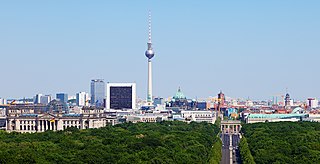
The Fernsehturm in central Berlin was constructed between 1965 and 1969 by the government of the German Democratic Republic, or East Germany, as both a functional broadcasting facility and a symbol of Communist power.

<span class="mw-page-title-main">Berlin U-Bahn</span> Rapid transport system of Berlin, Germany

The Berlin U-Bahn is a rapid transit system in Berlin, the capital and largest city of Germany, and a major part of the city's public transport system. Together with the S-Bahn, a network of suburban train lines, and a tram network that operates mostly in the eastern parts of the city, it serves as the main means of transport in the capital.

<span class="mw-page-title-main">U2 (Berlin U-Bahn)</span> Underground line in Berlin

U2 is a line of the Berlin U-Bahn. The U2 line starts at Pankow S-Bahn station, runs through the eastern city centre (Alexanderplatz) to Potsdamer Platz, the western city centre and finally to the Ruhleben terminal station.

<span class="mw-page-title-main">U5 (Berlin U-Bahn)</span>

U5 is a line on the Berlin U-Bahn. It runs from Hauptbahnhof in Mitte eastwards through Alexanderplatz, Friedrichshain, Lichtenberg and Friedrichsfelde, surfaces in Biesdorf-Süd to pass Kaulsdorf and Hellersdorf above ground and finally reaches city limits at Hönow.

<span class="mw-page-title-main">U6 (Berlin U-Bahn)</span>

U6 is a 19.9 km (12.4 mi) long rapid transit line on the Berlin U-Bahn with 29 stations. It runs in a north-south direction from the Berlin locality of Tegel in the north via Friedrichstraße to Mariendorf, a locality in the southern part of the city. It is one of the five large profile ("Großprofil") lines.

<span class="mw-page-title-main">Berlin Victory Column</span> Monument in Germany

The Victory Column is a monument in Berlin, Germany. Designed by Heinrich Strack after 1864 to commemorate the Prussian victory in the Second Schleswig War, by the time it was inaugurated on 2 September 1873, Prussia had also defeated Austria and its German allies in the Austro-Prussian War (1866) and France in the Franco-Prussian War (1870–71), giving the statue a new purpose. Different from the original plans, these later victories in the unification wars inspired the addition of the bronze sculpture of Victoria, the Roman goddess of victory, 8.3 metres (27 ft) high, designed by Friedrich Drake.

<span class="mw-page-title-main">Trams in Berlin</span> Overview of the tram system of Berlin, Germany

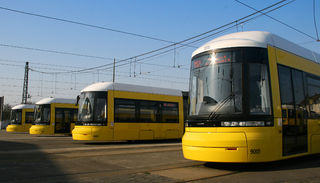
The Berlin tramway is the main tram system in Berlin, Germany. It is one of the oldest tram networks in the world having its origins in 1865 and is operated by Berliner Verkehrsbetriebe (BVG), which was founded in 1929. It is notable for being the third-largest tram system in the world, after Melbourne and St. Petersburg. Berlin's tram system is made up of 22 lines that operate across a standard gauge network, with almost 800 stops and measuring almost 190 kilometres (120 mi) in route length and 430 kilometres (270 mi) in line length. Nine of the lines, called Metrotram, operate 24 hours a day and are identified with the letter "M" before their number; the other thirteen lines are regular city tram lines and are identified by just a line number.

<span class="mw-page-title-main">World clock</span> Clock that displays the times in various locations around the globe

A world clock is a clock which displays the time for various cities around the world. The display can take various forms:

<span class="mw-page-title-main">Park Inn by Radisson Berlin Alexanderplatz</span> Tallest building and the eleventh-tallest structure in Berlin

The Park Inn by Radisson Berlin Alexanderplatz is the tallest building and the eleventh-tallest structure in Berlin and the 29th-tallest building and tallest hotel-only building in Germany. The 37-floor skyscraper is in the northeast of Alexanderplatz in the central Mitte district and has a height of 125 metres.

<span class="mw-page-title-main">Berlin Hauptbahnhof</span> Main railway station of Berlin, Germany

Berlin Hauptbahnhof is the main railway station in Berlin, Germany. It came into full operation two days after a ceremonial opening on 26 May 2006. It is located on the site of the historic Lehrter Bahnhof, and on the Berlin S-Bahn suburban railway. The station is operated by DB Station&Service, a subsidiary of Deutsche Bahn AG, and is classified as a Category 1 station, one of 21 in Germany and four in Berlin, the others being Berlin Gesundbrunnen, Berlin Südkreuz and Berlin Ostbahnhof.

<span class="mw-page-title-main">Karl-Liebknecht-Straße</span> Major street in the Berlin Mitte district

Karl-Liebknecht-Straße is a major street in the central Mitte district of the German capital Berlin. It is named after Karl Liebknecht (1871–1919), one of the founders of the Communist Party of Germany. The street connects the Unter den Linden boulevard with the Prenzlauer Allee arterial road leading to the northern city limits. Although part of the street dates back to medieval times, most of the buildings at its side were built in the 1960s, when East Berlin's centre was redesigned as the capital of East Germany.

<span class="mw-page-title-main">Berlin Ostkreuz station</span> Train station in Berlin

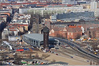
Berlin Ostkreuz station is a station on the Berlin S-Bahn suburban railway and the busiest interchange station in Berlin. It is in the former East Berlin district of Friedrichshain, now part of the borough of Friedrichshain-Kreuzberg. A smaller part of the station is in Rummelsburg, part of the borough of Lichtenberg. The station is a Turmbahnhof with the Berlin–Frankfurt (Oder) railway and the Prussian Eastern Railway on the lower level and the Berlin Ringbahn on the upper level. It is used by a total of around 235,000 passengers every day on eight lines, entering or leaving.

<span class="mw-page-title-main">Europa-Center</span> Building complex on Breitscheidplatz in the Charlottenburg district of Berlin

The Europa-Center is a building complex on Breitscheidplatz in the Charlottenburg district of Berlin, with a shopping mall and a high-rise tower 86 metres (282 ft) tall. Built between 1963 and 1965, by 2003 it had been designated as a historically preserved building.

<span class="mw-page-title-main">Mühlendamm</span>

Mühlendamm is a major thoroughfare in the central Mitte district of Berlin, Germany. It runs from the historic Cölln and Fischerinsel quarters to the Molkenmarkt square of Alt-Berlin via the Mühlendammbrücke crossing the Spree river. Named after several watermills at the site, a historic causeway was first laid out at this location about 1200 and became the nucleus of the late medieval city foundation. The current prestressed concrete bridge was built in 1968. It is part of an east–west road link to Berlin's city centre and the Bundesstraße 1 highway.

<span class="mw-page-title-main">Altes Stadthaus, Berlin</span> German administration building

Altes Stadthaus is a former administrative building in Berlin, Germany, currently used by the Senate. It faces the Molkenmarkt and is bound by four roads; Jüdenstraße, Klosterstraße, Parochialstraße, and Stralauer Straße. Designed by Ludwig Hoffmann, chief of construction for the city, it was built in 1902–11 at a cost of 7 million marks (US$1,750,000) to supplement the Rotes Rathaus.

<span class="mw-page-title-main">Embassy of France, Berlin</span> Diplomatic mission of France in Germany

The Embassy of France in Berlin is the diplomatic mission of the French Republic in Germany. Designed by Christian de Portzamparc and completed in 2002, it is at the same address, Pariser Platz 5, as the former embassy which was destroyed in World War II. Prior to German reunification, France had an embassy in the German Democratic Republic at a different address in Berlin and an embassy in the Federal Republic in Bonn.

<span class="mw-page-title-main">Geography of Berlin</span> Overview of the geography of Berlin

Berlin is the capital city of Germany and one of the 16 states of Germany. With a population of 3.4 million people, Berlin is the most populous city proper, the sixth most populous urban area in the European Union, and the largest German city.

<span class="mw-page-title-main">Architecture of Berlin</span> Overview of the architecture in Berlin

Berlin's history has left the city with an eclectic assortment of architecture. The city's appearance in the 21st century has been shaped by the key role the city played in Germany's 20th-century history. Each of the governments based in Berlin—the Kingdom of Prussia, the 1871 German Empire, the Weimar Republic, Nazi Germany, East Germany and the reunified Federal Republic of Germany—initiated ambitious construction programs, with each adding its distinct flavour to the city's architecture.

<span class="mw-page-title-main">Bamberg-Refraktor</span>

The Bamberg-Refraktor is a large telescope. The refracting telescope has an aperture of 320 millimetres, a focal length of five metres and is located in the Wilhelm Foerster Observatory in the Berlin district of Schöneberg.

References

  1. Helmut Caspar: Ärger mit der Weltzeituhr am Alex. Städtenamen sind nicht korrekt. In: Märkische Allgemeine Zeitung , 24/25 December 1997.
  2. Uwe Aulich: Denkmalschutz für DDR-Häuser am Alex. In: Berliner Zeitung , 14 July 2015, S. 15.
  3. 1 2 3 4 5 Auskunft des Gestalters der Weltzeituhr, Erich John.
  4. Homepage von Weltzeituhr Berlin Alexanderplatz Kunsch Metallbau; Referenzobjekte, retrieved 23 July 2018.
  5. Frisch poliert: Die Weltzeituhr dreht sich bald. In: Berliner Zeitung , 12 December 1997, retrieved 3 July 2013.
  6. Weltzeituhr tickt jetzt wieder richtig. In: taz , 20 December 1997.
  7. Weltzeituhr – Treffpunkt mit Innenleben. In: Berliner Zeitung , 30 January 2007, Retrieved 3 July 2013.
  8. Udo Baron: Kalter Krieg und heißer Frieden. Lit Verlag, Münster 2003, ISBN   3-8258-6108-2, S. 188

52°31′16″N13°24′48″E / 52.52117°N 13.41332°E / 52.52117; 13.41332