
The Desolation Wilderness is a 63,960-acre (258.8 km2) federally protected wilderness area in the Eldorado National Forest and Lake Tahoe Basin Management Unit, in El Dorado County, California. The crest of the Sierra Nevada runs through it, just west of Lake Tahoe.

West Sister Island is an island of the U.S. state of Ohio located in the Western Basin of Lake Erie. The 82 acres (33 ha) island, jointly managed by the United States Coast Guard and the U.S. Fish and Wildlife Service, is Ohio's only designated Wilderness Area, the West Sister Island National Wildlife Refuge.

Ross Lake National Recreation Area is a US national recreation area in north central Washington just south of the Canada–US border. It is the most accessible part of the North Cascades National Park Complex which also includes North Cascades National Park and Lake Chelan National Recreation Area. Ross Lake NRA follows the Skagit River corridor from the Canada–US border to the western foothills of the Cascades. The NRA contains a portion of scenic Washington State Route 20, the North Cascades Highway, and includes three reservoirs: 12,000-acre (4,900 ha) Ross Lake, 910-acre (370 ha) Diablo Lake, and 210-acre (85 ha) Gorge Lake. These reservoirs make up the Skagit River Hydroelectric Project operated by Seattle City Light. Nestled in the "American Alps" the Ross Lake NRA bisects the north and south units of North Cascades National Park.

Eldorado National Forest is a U.S. National Forest located in the central Sierra Nevada mountain range, in eastern California.

The Alpine Lakes Wilderness is a large wilderness area spanning the Central Cascades of Washington state in the United States. The wilderness is located in parts of Wenatchee National Forest and Snoqualmie National Forest, and is approximately bounded by Interstate 90 and Snoqualmie Pass to the south and U.S. Route 2 and Stevens Pass to the north. The Alpine Lakes is the largest wilderness area near the population centers of Puget Sound, counted at 414,161 acres (167,605 ha) following the 2014 expansion.

Glacier Peak Wilderness is a 566,057-acre (229,075 ha), 35-mile-long (56 km), 20-mile-wide (32 km) wilderness area located within portions of Chelan, Snohomish, and Skagit counties in the North Cascades of Washington. The area lies within parts of Wenatchee National Forest and Mount Baker National Forest and is characterized by heavily forested stream courses, steep-sided valleys, and dramatic glacier-crowned peaks. The dominant geologic feature of the area is 10,541-foot (3,213 m) Glacier Peak. It is the most remote major volcanic peak in the Cascade Range and is the third most heavily glaciated volcano in the lower forty-eight states behind Mount Rainier and Mount Baker. Glacier Peak is a volcanic cone of basalt, pumice, and ash which erupted during periods of heavy glaciation.

Hell Hole Reservoir is an artificial, crescent-shaped lake in the Sierra Nevada mountain range 10 miles (16 km) west of Lake Tahoe in California, United States. The lake is about 3.5 miles (5.6 km) long when at full capacity.
Pyramid Peak is a mountain in the California's Sierra Nevada in the Crystal Range to the west of Lake Tahoe. It is the highest point in the Desolation Wilderness. With an elevation gain of almost 4,100 feet (1,250 m), the Rocky Canyon route is the mountain's most popular approach although it is very arduous. To the east, at the base of the peak, lies Pyramid Lake.
Merrymeeting Lake is a 1,233-acre (4.99 km2) water body located in Strafford County in eastern New Hampshire, United States, in the town of New Durham. Its outlet is the Merrymeeting River, flowing south and then northwest to Lake Winnipesaukee.
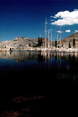
Lake Aloha is a large shallow backcountry reservoir located at an elevation of 8,116 ft (2,474 m) in the Sierra Nevada Range, west of Lake Tahoe in El Dorado County, in eastern California.

The Crystal Range is a small chain of mountain peaks in the Desolation Wilderness in the U.S. state of California. It is a subrange of the Sierra Nevada. The highest and most southerly peak is Pyramid Peak at 9985 ft; Mount Agassiz is next north at 9967 ft, with Mount Price (9975 ft) rounding out the southern group of peaks. Tells Peak is the northernmost named peak in the range.

Gilmore Lake in California is a backcountry lake in the Sierra Nevada mountain range, to the west of Lake Tahoe in the Desolation Wilderness. It can be reached by hiking west out of the Glen Alpine Springs trailhead near the town of South Lake Tahoe. This lake offers great fishing for Lake trout.
The Lyons trailhead or Lyons Creek trailhead is located on Wrights Lake Road off Highway 50 about halfway to Wrights Lake.

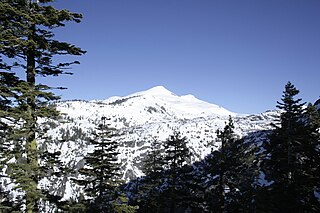
Mount Tallac is a mountain peak southwest of Lake Tahoe, in El Dorado County, California. The peak lies within the Desolation Wilderness in the Eldorado National Forest. It is quite visible from State Routes 89 and 28, and U.S. Route 50. A "cross of snow" is clearly visible on the mountain's face during the winter, spring, and early summer months.

The Mount Washington Wilderness is a wilderness area located on and around Mount Washington in the central Cascade Range of Oregon in the United States. The wilderness was established in 1964 and comprises 54,278 acres (219.66 km2) of the Willamette National Forest and Deschutes National Forest. It is administered by the U.S. Forest Service.

Mount Agassiz, at 13,899 feet (4,236 m), is one of the 20 highest peaks of California. It is the northernmost and easiest to climb of the major Palisades summits. This peak is not to be confused with the 9,967-foot (3,038 m) peak by the same name in Desolation Wilderness, also in the California Sierra.

The Dinkey Lakes Wilderness is a federally designated wilderness area located 45 miles (72 km) northeast of Fresno, in the state of California, United States. It comprises 30,000 acres (12,141 ha) within the Sierra National Forest and was added to the National Wilderness Preservation System by the California Wilderness Act of 1984. Elevations range from 8,200 feet (2,500 m) to 10,619 feet (3,237 m). Recreational activities in the wilderness include day hiking, backpacking, horseback riding, fishing, rock climbing and cross-country skiing.
The Harcuvar Mountains are a narrow mountain range in western-central Arizona, United States. The range lies just east of the north–south Colorado River, and south of the east–west, west-flowing Bill Williams River, from Alamo Lake.
Desolation Peak is located in the northern Wind River Range in the U.S. state of Wyoming. Situated .66 mi (1.06 km) west of Rampart Peak, Desolation Peak is within the Bridger Wilderness of Bridger-Teton National Forest and west of the Continental Divide. Desolation Peak is the 22nd tallest peak in Wyoming.
Silver Creek is a major tributary of the South Fork American River in the Sierra Nevada mountain range.


