Wum is the third biggest town in the north west region of Cameroon. It lies on a plateau at an elevation of about 1100 m near the edge of the western highlands of Cameroon. It is 80 kilometres (50mi) north of the regional capital Bamenda (by dirt road). It lies near Lake Wum, one of five small crater lakes within 15km of the town in the hilly, volcanic landscape. Lake Nyos, a crater lake from which a limnic eruption killed nearly 2,000 people in 1986, is 25km to the east.
Population and language
In 2012 Wum's estimated population was 80,123 inhabitants.[1]
The Aghem language, spoken in Wum, is also called Wum.[2]
Domestic Science Centre at Wum (old photograph)
Culture
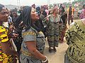
Traditional clothing
Notable people
AkuBai (Ningamai Akubai Nnam), singer and entrepreneur
This page is based on this Wikipedia article Text is available under the CC BY-SA 4.0 license; additional terms may apply. Images, videos and audio are available under their respective licenses.