
A weather station is a facility, either on land or sea, with instruments and equipment for measuring atmospheric conditions to provide information for weather forecasts and to study the weather and climate. The measurements taken include temperature, atmospheric pressure, humidity, wind speed, wind direction, and precipitation amounts. Wind measurements are taken with as few other obstructions as possible, while temperature and humidity measurements are kept free from direct solar radiation, or insolation. Manual observations are taken at least once daily, while automated measurements are taken at least once an hour. Weather conditions out at sea are taken by ships and buoys, which measure slightly different meteorological quantities such as sea surface temperature (SST), wave height, and wave period. Drifting weather buoys outnumber their moored versions by a significant amount.

Mount Mitchell is the highest peak of the Appalachian Mountains and the highest peak in mainland North America east of the Mississippi River. It is located near Burnsville in Yancey County, North Carolina in the Black Mountain subrange of the Appalachians about 19 miles (31 km) northeast of Asheville. It is protected by Mount Mitchell State Park and surrounded by the Pisgah National Forest. Mount Mitchell's elevation is 6,684 feet (2,037 m) above sea level. Mount Mitchell is ranked 31st by topographic isolation.

In meteorology, precipitation is any product of the condensation of atmospheric water vapor that falls from clouds due to gravitational pull. The main forms of precipitation include drizzle, rain, sleet, snow, ice pellets, graupel and hail. Precipitation occurs when a portion of the atmosphere becomes saturated with water vapor, so that the water condenses and "precipitates" or falls. Thus, fog and mist are not precipitation; their water vapor does not condense sufficiently to precipitate, so fog and mist do not fall. Two processes, possibly acting together, can lead to air becoming saturated with water vapor: cooling the air or adding water vapor to the air. Precipitation forms as smaller droplets coalesce via collision with other rain drops or ice crystals within a cloud. Short, intense periods of rain in scattered locations are called showers.

METAR is a format for reporting weather information. A METAR weather report is predominantly used by aircraft pilots, and by meteorologists, who use aggregated METAR information to assist in weather forecasting.

Numerical weather prediction (NWP) uses mathematical models of the atmosphere and oceans to predict the weather based on current weather conditions. Though first attempted in the 1920s, it was not until the advent of computer simulation in the 1950s that numerical weather predictions produced realistic results. A number of global and regional forecast models are run in different countries worldwide, using current weather observations relayed from radiosondes, weather satellites and other observing systems as inputs.
The National Collegiate Weather Forecasting Contest, or NCWFC, was a yearly competition among colleges and Universities in the US run by Penn State. There were over 1000 participants from about 45 institutions. In 2006, the competition was transferred to the University of Oklahoma and run as the WxChallenge.
In weather forecasting, model output statistics (MOS) is a multiple linear regression technique in which predictands, often near-surface quantities, are related statistically to one or more predictors. The predictors are typically forecasts from a numerical weather prediction (NWP) model, climatic data, and, if applicable, recent surface observations. Thus, output from NWP models can be transformed by the MOS technique into sensible weather parameters that are familiar to a layperson.

The characteristics of United States rainfall climatology differ significantly across the United States and those under United States sovereignty. Summer and early fall bring brief, but frequent thundershowers and tropical cyclones which create a wet summer and drier winter in the eastern Gulf and lower East Coast. During the winter, and spring, Pacific storm systems bring Hawaii and the western United States most of their precipitation. Low pressure systems moving up the East Coast and through the Great Lakes, bring cold season precipitation to from the Midwest to New England, as well as Great Salt Lake. The snow to liquid ratio across the contiguous United States averages 13:1, meaning 13 inches (330 mm) of snow melts down to 1 inch (25 mm) of water.

The quantitative precipitation forecast is the expected amount of melted precipitation accumulated over a specified time period over a specified area. A QPF will be created when precipitation amounts reaching a minimum threshold are expected during the forecast's valid period. Valid periods of precipitation forecasts are normally synoptic hours such as 00:00, 06:00, 12:00 and 18:00 GMT. Terrain is considered in QPFs by use of topography or based upon climatological precipitation patterns from observations with fine detail. Starting in the mid-to-late 1990s, QPFs were used within hydrologic forecast models to simulate impact to rivers throughout the United States. Forecast models show significant sensitivity to humidity levels within the planetary boundary layer, or in the lowest levels of the atmosphere, which decreases with height. QPF can be generated on a quantitative, forecasting amounts, or a qualitative, forecasting the probability of a specific amount, basis. Radar imagery forecasting techniques show higher skill than model forecasts within 6 to 7 hours of the time of the radar image. The forecasts can be verified through use of rain gauge measurements, weather radar estimates, or a combination of both. Various skill scores can be determined to measure the value of the rainfall forecast.

Kentucky is situated in the Upland South region of the United States. A significant portion of eastern Kentucky is part of Appalachia.

Arizona is a landlocked state situated in the southwestern region of the United States of America. It has a vast and diverse geography famous for its deep canyons, high- and low-elevation deserts, numerous natural rock formations, and volcanic mountain ranges. Arizona shares land borders with Utah to the north, the Mexican state of Sonora to the south, New Mexico to the east, and Nevada to the northwest, as well as water borders with California and the Mexican state of Baja California to the southwest along the Colorado River. Arizona is also one of the Four Corners states and is diagonally adjacent to Colorado.

The climate of New York (state) is generally humid continental, while the extreme southeastern portion of the state lies in the warmer humid subtropical climate zone. Winter temperatures average below freezing during January and February in much of the state of New York, but several degrees above freezing along the Atlantic coastline, including New York City and Long Island.
A prognostic chart is a map displaying the likely weather forecast for a future time. Such charts generated by atmospheric models as output from numerical weather prediction and contain a variety of information such as temperature, wind, precipitation and weather fronts. They can also indicate derived atmospheric fields such as vorticity, stability indices, or frontogenesis. Forecast errors need to be taken into account and can be determined either via absolute error, or by considering persistence and absolute error combined.

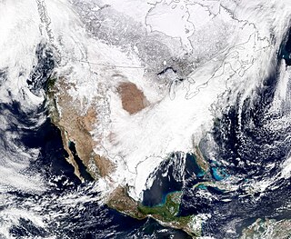
The 2014–15 North American winter was frigid and prolifically wintry, especially across the eastern half of North America in the months of January–March, in addition to having the most amount of storms rated on the Regional Snowfall Index (RSI), with 11 such storms being designated. The season began early, with many places in North America experiencing their first wintry weather during mid-November. A period of below-average temperatures affected much of the contiguous United States, and several records were broken. A quasi-permanent phenomenon referred to as the polar vortex may have been partly responsible for the cold weather. Temperatures in much of the United States dropped 15 to 35 °F below average by November 19, following a southward "dip" of the polar vortex into the eastern two-thirds of the country. The effects of this dip were widespread, bringing about temperatures as low as 28 °F (−2 °C) in Pensacola, Florida. Following a significant snowstorm there, Buffalo, New York received several feet of snow from November 17–21. In addition, significant winter weather occurred throughout the season, including a major blizzard that struck the Northeastern United States at the end of January, another blizzard that affected much of the Northern United States days later in early February, and several significant snow events paired with very frigid temperatures for much of February.

The 2015–16 North American winter was not as frigid across North America and the United States as compared to the 2013–14 and 2014–15 winters. This was mainly due to a strong El Niño, which caused generally warmer-than-average conditions. However, despite the warmth, significant weather systems still occurred, including a snowstorm and flash flooding in Texas at the end of December and a large tornado outbreak at the end of February. The main event of the winter season, by far and large, was when a crippling and historic blizzard struck the Northeastern United States in late January, dumping up to 3 feet of snow in and around the metropolitan areas. Several other smaller snow events affected the Northeast as well, but for the most part the heaviest snowstorms and ice stayed out further west, such as a severe blizzard in western Texas in late December, and a major late-season snowstorm in Colorado in mid-April.

The 2011–12 North American winter by and large saw above normal average temperatures across the continent, with the Contiguous United States encountering its fourth-warmest winter on record, along with an unusually low number of significant winter precipitation events. The primary outlier was Alaska, parts of which experienced their coldest January on record.

The 2019–20 North American winter was unusually warm for many parts of the United States; in many areas, neutral ENSO conditions controlled the weather patterns, resulting in strong El Niño like conditions and the sixth-warmest winter on record, and many areas in the Northeastern United States saw one of the least snowy winters in years. In fact, Baltimore and Islip saw no snow in February for the first time. Some notable events still occurred, such as a powerful blizzard that impacted the Western United States in late November, a series of cold shots in January and February, a snowstorm within the Texas Panhandle and a late-season blizzard in the High Plains.
The 2021–22 North American winter was not as significant and record-breaking as the previous winter season. Despite this, several notable and significant events still occurred, including two separate record-breaking tornado outbreaks in mid-December, a significant winter storm in the South in mid-January, a powerful blizzard that impacted the Northeast coast at the end of January and a wide-ranging, significant winter storm that affected most of the eastern half of the country in early February. Additional significant events included a late-season winter storm in March that affected the Appalachian Mountains, and a major blizzard that affected North and South Dakota in mid-April. Additionally, a very late out-of-season snowstorm struck the Rocky Mountains in late May. During the season, four storms have been ranked on the Regional Snowfall Index (RSI), although none attained the “Major” category. Similar to the previous winter, a developing La Niña was expected to influence weather patterns across the continent.
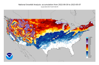
The 2022–23 North American winter was an unusually warm winter for the east and an unusually cold winter for the west in North America, as it occurred across the continent from late 2022 to early 2023. The winter season in North America began at the winter solstice, which occurred on December 21, 2022, and it ended at the March equinox, which occurred on March 20, 2023. The first day of meteorological winter began on December 1 and unofficially ended on February 28; winter storms may still occur outside of these limits.
