
Modesto, officially the City of Modesto, is the county seat and largest city of Stanislaus County, California, United States. With a population of approximately 201,165 at the 2010 census, it is the 18th largest city in the state of California and forms part of the San Jose-San Francisco-Oakland Combined Statistical Area.

The Tuolumne River flows for 149 miles (240 km) through Central California, from the high Sierra Nevada to join the San Joaquin River in the Central Valley. Originating at over 8,000 feet (2,400 m) above sea level in Yosemite National Park, the Tuolumne drains a rugged watershed of 1,958 square miles (5,070 km2), carving a series of canyons through the western slope of the Sierra. While the upper Tuolumne is a fast-flowing mountain stream, the lower river crosses a broad, fertile and extensively cultivated alluvial plain. Like most other central California rivers, the Tuolumne is dammed multiple times for irrigation and the generation of hydroelectricity.

A body of water or waterbody is any significant accumulation of water, generally on a planet's surface. The term most often refers to oceans, seas, and lakes, but it includes smaller pools of water such as ponds, wetlands, or more rarely, puddles. A body of water does not have to be still or contained; rivers, streams, canals, and other geographical features where water moves from one place to another are also considered bodies of water.

Rock Creek is a free-flowing tributary of the Potomac River that empties into the Atlantic Ocean via the Chesapeake Bay. The 32.6-mile (52.5 km) creek drains about 76.5 square miles (198 km2). Its final quarter-mile is affected by tides.
Peachtree Creek is a major stream in Atlanta. It flows for 7.5 miles (12.1 km) almost due west into the Chattahoochee River just south of Vinings.
Mill Creek is an 8.7-mile-long (14.0 km) tributary stream of Patterson Creek in Mineral County, West Virginia. It is also known as Mill Run.

The Chowchilla River is a river in central California, United States and a minor tributary of the San Joaquin River. It flows for 54.2 miles (87.2 km) from the western side of the Sierra Nevada Range to the San Joaquin River system in the San Joaquin Valley.

Clear Creek is a stream in northeast Atlanta that is a tributary to Peachtree Creek and part of the Chattahoochee River watershed. It has two main branches, one originating east of the high ground along which Boulevard runs and another to the west originating on the northeast side of downtown Atlanta. The easterly branch of Clear Creek begins in several springs and branches in what are now Inman Park and the Old Fourth Ward. Flowing north, the creek was joined by other branches and springs, including Angier Springs near the end of Belgrade Avenue and the so-called Ponce de Leon Springs, which were “discovered” during railroad construction in the 1860s and gave rise to the eponymous park and avenue.
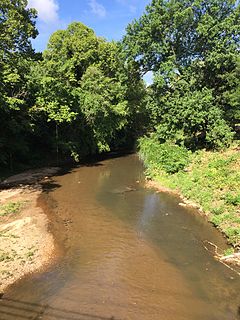
Dry Creek is a stream in Stanislaus County, California, that is a tributary to the Tuolumne River.

Town Creek is a neighborhood in the Lake Highlands area of Dallas, Texas (USA). It is generally bounded by Royal Lane on the south, Abrams Road on the west, Whitehurst Drive and Atherton Drive on the north, and a tributary of White Rock Creek on the east. However, it generally excludes the apartments and shopping center located within those boundaries.

Iron Cove Creek, a southern tributary of the Parramatta River, is an urban stream west of Sydney Harbour, located in the inner-western Sydney suburbs of Croydon, Ashfield, Haberfield and Five Dock in New South Wales, Australia.
The Tuolumne River Regional Park is a large urban park under development along a seven-mile (11 km) stretch of the Tuolumne River between the cities of Ceres, California and Modesto, California consisting of 500 acres(.78 mi2, 2.02 km2) of public grounds in Stanislaus County, California.
Saleyards Creek is a canalised urban stream, acting as a stormwater channel, located in Sydney, Australia. Its upstream course follows approximately the boundary between the suburbs of Homebush and Homebush West. North of Parramatta Road, both sides of the creek fall within Homebush.

Villa Park is a neighborhood of Denver, Colorado.

Adobe Creek is a 14.2-mile-long (22.9 km) northward-flowing stream originating on Black Mountain in Santa Clara County, California, United States. It courses through the cities of Los Altos Hills, Los Altos, and Palo Alto. Historically, Adobe Creek was perennial and hosted runs of steelhead trout entering from southwestern San Francisco Bay.
Piney Branch is a tributary of Rock Creek in Washington, D.C. It is the largest tributary located entirely within the Washington city limits.
Leach Creek is a tributary of Leggetts Creek in Lackawanna County, Pennsylvania, in the United States. It is approximately 1.9 miles (3.1 km) long and flows through Scranton. The watershed of the creek has an area of 2.55 square miles (6.6 km2). The creek loses substantial amounts of water to underground mine pools. The creek is in the Coal Region and has been channelized and/or culvertized in some reaches. It flows alongside Pennsylvania Route 307 for a substantial part of its length. The creek has a riparian buffer in its upper and middle reaches, but various invasive plants grow along its banks in its lower reaches.