Related Research Articles

Lismore is a city in northeastern New South Wales, Australia and the main population centre in the City of Lismore local government area; it is also a regional centre in the Northern Rivers region of the State. It is situated on a low flood plain on the banks of the Wilsons River near the latter's junction with Leycester Creek, both tributaries of the Richmond River which enters the Pacific Ocean at Ballina, 30 km to the east. The original settlement initially developed as a grazing property, then became a timber and agricultural based town and inland port based around substantial river traffic, which declined and then ceased around the mid twentieth century. The city is also located on the Bruxner Highway which crosses the Wilsons River at Lismore, and was formerly a stop on the Casino-Murwillumbah railway line. It is the home of one of the three campuses of Southern Cross University.

Northern Rivers is the most north-easterly region of the Australian state of New South Wales, located between 590 kilometres (370 mi) and 820 kilometres (510 mi) north of the state capital, Sydney, and encompasses the catchments and fertile valleys of the Clarence, Richmond and Tweed rivers. It extends from Tweed Heads in the north to the southern extent of the Clarence river catchment which lies between Grafton and Coffs Harbour, and includes the main towns of Tweed Heads, Byron Bay, Ballina, Kyogle, Lismore, Casino and Grafton. At its most northern point, the region is 102 kilometres (63 mi) south south–east of the Queensland capital, Brisbane.

Casino is a town in the Northern Rivers area of New South Wales, Australia, with a population of 10,914 people at the 2016 census. It lies on the banks of the Richmond River and is situated at the junction of the Bruxner Highway and the Summerland Way.
The Richmond River is a river with a mature wave dominated, barrier estuary, situated in the Northern Rivers region of New South Wales, Australia.

Evans Head is a town in Richmond Valley Council of the Northern Rivers region of New South Wales, Australia. At the 2016 census, Evans Head had a population of 2,843 people. It is 726 kilometres north of Sydney, and 11 kilometres east off the Pacific Highway from Woodburn.

The Division of Richmond is an Australian electoral division in the state of New South Wales.

Woodburn is a small highway town on the banks of the Richmond River in New South Wales, Australia. The busy Pacific Highway passes through the centre of town. Woodburn is 712 km north of the state capital, Sydney, and 34 km south of the regional city of Lismore.

The City of Lismore is a local government area in the Northern Rivers region of New South Wales, Australia. The seat of the local government area is Lismore, a major regional centre of the state.

The Channon is a village in the Northern Rivers area of New South Wales, Australia. It is about 18 kilometres northwest of Lismore and about 21 km from Nimbin, NSW. It is part of the City of Lismore. The name of the village, Channon, comes from a local Aboriginal term for the Burrawang palm, a type of cycad that proliferates along the ridgelines in the area.

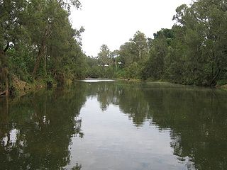
Wilsons River, a perennial river and part of the Richmond River catchment, is situated in the Northern Rivers district of New South Wales, Australia.
Barcoongere River, a watercourse of the Wooli Wooli River catchment, is located in the Northern Rivers region of New South Wales, Australia.
The Leycester Creek, a perennial stream of the Richmond River catchment, is located in Northern Rivers region in the state of New South Wales, Australia.

New Italy is a village near Woodburn in the Northern Rivers district in New South Wales, Australia. The busy Pacific Highway passes nearby. New Italy is 693 km north-east of the state capital, Sydney, and 12 km south of Woodburn.
Lismore High Campus, part of The Rivers Secondary College, is a government-funded co-educational comprehensive secondary day school campus, located on Dalley Street, East Lismore, in the Northern Rivers region of New South Wales, Australia.
Oakes Oval is a cricket ground in Lismore, New South Wales, Australia. The first recorded match on the ground came in 1934 when Richmond River Colts played New South Wales Colts. The ground held matches in the 1978 and 1979 World Series Cricket. It held its first first-class match in 1979 when New South Wales played Queensland in the Sheffield Shield. The next first-class match to be staged there came in 1991 when New South Wales played the touring Indians. A further first-class match was held there in the 2006 Pura Cup between New South Wales and Victoria. A single List A match has been played there, which came in 1992 when New South Wales played the touring West Indians.
Evans River, an open and trained youthful wave dominated, interbarrier estuary, is located in the Northern Rivers region of New South Wales, Australia.

The Back Creek, a perennial stream of the Richmond River catchment, is located in Northern Rivers region in the state of New South Wales, Australia.
The Coopers Creek, a perennial stream of the Richmond River catchment, is located in Northern Rivers region in the state of New South Wales, Australia.
The Eden Creek, a perennial stream of the Richmond River catchment, is located in Northern Rivers region in the state of New South Wales, Australia.

The Nightcap Range is a mountain range located in the Northern Rivers region of New South Wales, Australia, in the area between Lismore and the New South Wales-Queensland border. It includes Mount Burrell and Mount Nardi as well as containing the Nightcap National Park. The range is mainly covered with relict warm temperate rainforest and contains several rare and/or endemic species, most notably the Nightcap oak and the Minyon quandong.
References
- ↑ "Wyrallah". Geographical Names Register (GNR) of NSW. Geographical Names Board of New South Wales . Retrieved 24 May 2011.

Coordinates: 28°54′S153°18′E / 28.900°S 153.300°E
| This Northern Rivers geography article is a stub. You can help Wikipedia by expanding it. |