
The Grand Union Canal in England is part of the British canal system. It is the principal navigable waterway between London and the Midlands. Starting in London, one arm runs to Leicester and another ends in Birmingham, with latter stretching for 137 miles (220 km) with 166 locks from London. The Birmingham line has a number of short branches to places including Slough, Aylesbury, Wendover, and Northampton. The Leicester line has two short arms of its own, to Market Harborough and Welford.
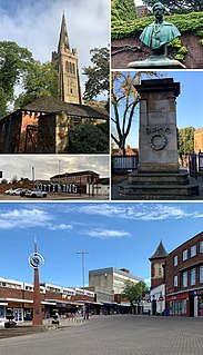
Kettering is a market and industrial town in North Northamptonshire, England. It is located 83 miles (134 km) north of London and 15 miles (24 km) north-east of Northampton, west of the River Ise, a tributary of the River Nene. The name means "the place of Ketter's people ".
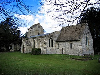
Biddlesden is a village and civil parish in Aylesbury Vale district in north-west Buckinghamshire, England on the boundary with Northamptonshire. It is about 5 miles (8 km) east-north-east of Brackley, Northamptonshire and 5 miles (8 km) north-west of Buckingham. The River Great Ouse forms part of the western boundary of the parish, separating the village from Northamptonshire. The ancient royal forest of Whittlewood extended to the northern edge of the village.
Byfield is a village and civil parish forming part of West Northamptonshire, England. The population of the civil parish at the 2011 census was 1,277.

Staverton is a village and civil parish in the south-west of Northamptonshire, England. It is 2.3 miles west of Daventry, 7.9 miles east of Southam and 15.3 miles east of Leamington Spa. It straddles the A425 road from Daventry to Leamington. The Jurassic Way long distance footpath between Banbury and Stamford passes through the village.
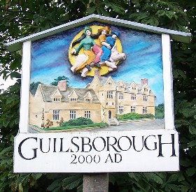
Guilsborough is a village and civil parish in West Northamptonshire in England. At the time of the 2001 census, the parish's population was 882 people, reducing to 692 at the 2011 Census.

Dodford is a village in West Northamptonshire, England. Prior to local government changes in 2021 it was within the Weedon Ward of Daventry District. The village is just north of the A45 road 1½ miles west of Weedon. The population of the civil parish at the 2011 Census was 203. It is 3½ miles east of Daventry and ten miles west of Northampton. It is also close to junction 16 of the M1 motorway. The parish consists of some 1,384 acres and is bounded on the east by the A5 trunk road which is the old Roman road of Watling Street. Most of the village and parish sits astride the valley of an east-flowing stream which is a tributary of the River Nene.

Charwelton is a village and civil parish about 5 miles (8 km) south of Daventry in Northamptonshire, England. The 2011 Census recorded the parish's population as 220.

Sulgrave is a village and civil parish in West Northamptonshire, England, about 5 miles (8 km) north of Brackley. The village is just south of a stream that rises in the parish and flows east to join the River Tove, a tributary of the Great Ouse.

Isham is a village and civil parish in Northamptonshire, England. It is on the A509 road, three miles south of Kettering and a mile to the west of Burton Latimer. The River Ise is to the east of the village. Administratively, it forms part of North Northamptonshire. It was previously in the Borough of Wellingborough until 2021. At the time of the 2011 census, the parish's population was 772 people.

Eydon is a village and civil parish in West Northamptonshire, about 8 miles (13 km) north-east of Banbury. The village is between 510 and 540 feet (160 m) above sea level on the east side of a hill, which rises to 580 feet (180 m) and is the highest point in the parish. The parish is bounded to the west by the River Cherwell, to the south by a stream that is one of its tributaries, and to the east and north by field boundaries.
Mawsley is a newly built village and civil parish in North Northamptonshire, England. At the time of the 2011 census, the parish had a population of 2,320.

Islip is a village and civil parish in North Northamptonshire, England. The village is just west of Thrapston and 7 miles (11 km) east of Kettering. The parish is bounded to the east by the River Nene and to the north by Harpurs Brook, a tributary of the Nene. The 2011 Census recorded the parish's population as 829 people.
Thenford is a village and civil parish about 5 miles (8 km) northwest of the market town of Brackley in West Northamptonshire, England, and 4 miles (6.4 km) east of Banbury in nearby Oxfordshire. The 2001 Census recorded the parish population as 74. At the 2011 Census the population of the village remained less than 100 and is included in the civil parish of Middleton Cheney.

Irchester is a village and civil parish in North Northamptonshire, two miles (3 km) south-east of Wellingborough and two miles south-west of Rushden. The population of the village at the 2011 Census was 5,706 and estimated in 2019 at 5,767. Little Irchester and Knuston also lie in the parish.
Orlingbury is a village and civil parish in the English county of Northamptonshire. It is between the towns of Kettering and Wellingborough. Administratively it forms part of North Northamptonshire but was in the borough of Wellingborough until 2021. At the time of the 2011 census, the parish's population was 439 people.

Great Harrowden is a village and civil parish in North Northamptonshire, with a population at the 2011 census of 161. The village sits astride the busy A509 running between Kettering and Wellingborough - although a bypass is due to be built shortly. The village forms part of the Orlingbury hundred.
Overthorpe is a village an civil parish in West Northamptonshire, about 2 miles (3 km) east of Banbury in Oxfordshire and 1 mile (1.6 km) southeast of junction 11 of the M40 motorway. Overthorpe is in the east of nshire, and its western boundary forms part of the county boundary with Oxfordshire. It is part of the informal district of Banburyshire.
Chacombe is a village and civil parish in West Northamptonshire, England, about 3 miles (5 km) north-east of Banbury. It is bounded to the west by the River Cherwell, to the north by a tributary and to the south-east by the Banbury–Syresham road. The 2011 Census gave a parish population of 659 and a 2019 estimate 693.
Radstone is a hamlet and civil parish in West Northamptonshire, about 2 miles (3 km) north of Brackley. The 2001 Census recorded a parish population of 54. At the 2011 Census the population of the hamlet remained less than 100 and was included in the civil parish of Whitfield.

