Orlingbury

Last updated

Orlingbury
Northamptonshire UK location map.svg
Red pog.svg
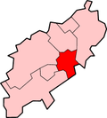
Orlingbury
Location within Northamptonshire
Population439  (2011 census)
OS grid reference SP8672
Unitary authority
Ceremonial county
Region
Country England
Sovereign state United Kingdom
Post town Kettering
Postcode district NN14
Dialling code 01933
Police Northamptonshire
Fire Northamptonshire
Ambulance East Midlands
UK Parliament
List of places
UK
England
Northamptonshire
52°20′22″N0°44′02″W / 52.3394°N 0.7339°W / 52.3394; -0.7339 Coordinates: 52°20′22″N0°44′02″W / 52.3394°N 0.7339°W / 52.3394; -0.7339

Orlingbury is a village and civil parish in the English county of Northamptonshire. It is between the towns of Kettering and Wellingborough. Administratively it forms part of North Northamptonshire but was in the borough of Wellingborough until 2021. At the time of the 2011 census, the parish's population was 439 people. [1]

Contents

The villages name origin is uncertain. 'Grove', 'woodland swine-pasture', 'hill' or 'fortification' connected with Ordla'. The hundred takes its name from Orlingbury. The site of the meeting-place is unknown. The west part of Orlingbury hundred was Mawsley hundred. [2]

Notable buildings

The Historic England website contains details of a total of 16 listed buildings in the parish of Orlingbury. [3] Those which are Grade II* are:

The Village Hall can be found at Rectory Lane and The Queen's Arms public house at Isham Road.

Wythmail

The site of the deserted village of Wythmail is in the parish of Orlingbury.

Cricket ground

On the outskirts of Orlingbury is a cricket ground, home of Isham Cricket Club [9] who play in Division 1 of The Northamptonshire County League. Past players have included Stephen Fleming (New Zealand national cricket team Captain), Johann Myburgh (SA Titans) and John Hughes (Northamptonshire County Cricket Club).

According to local folklore, the man who killed the last wolf in England is buried in the church. He is known locally as Jock of Badsaddle. [10]

Related Research Articles

Garsington Human settlement in England

Garsington is a village and civil parish about 5 miles (8 km) southeast of Oxford in Oxfordshire. The 2011 Census recorded the parish's population as 1,689. The village is known for the flamboyant social life at Garsington Manor when it was the home from 1914 to 1928 of Philip and Ottoline Morrell, and for the Garsington Opera which was staged here from 1989 until 2010.

Wellingborough Market town in Northamptonshire, England

Wellingborough is a market town in North Northamptonshire, England, 11 miles (18 km) from Northampton on the north side of the River Nene.

Borough of Wellingborough Borough in England

The Borough of Wellingborough was from 1974 to 2021 a non-metropolitan district and borough in Northamptonshire, England. It was named after Wellingborough, its main town, but also included surrounding rural areas.

East Farndon Human settlement in England

East Farndon is a small linear village and civil parish about one mile south of Market Harborough in West Northamptonshire, England. The village is close to the border with Leicestershire, and has a Leicestershire post code and telephone dialling code. At the time of the 2001 census, the parish's population was 258 people, increasing to 307 at the 2011 census.

Barby, Northamptonshire Human settlement in England

Barby is a village and civil parish about 5 miles (8 km) north of Daventry in Northamptonshire, England. The 2011 Census recorded the parish population as 2,336. Barby is located right off the M45 motorway a short spur from the M1 motorway to the A45 Trunk Road.

Old, Northamptonshire Human settlement in England

Old is a village and civil parish in West Northamptonshire, England. At the time of the 2001 census, the parish's population was 308 people, and the population increased to 490 at the 2011 Census.

Maidwell Human settlement in England

Maidwell is a village and civil parish in West Northamptonshire in England. At the time of the 2001 census, the parish had 325 inhabitants, including Draughton, and this increased to 429 at the 2011 census.

Holcot Human settlement in England

Holcot is a village and civil parish in the West Northamptonshire in England. At the time of the 2001 census, the parish's population was 399 people. At the 2011 census this had increased to 438 people, living in 182 households.

Haselbech Human settlement in England

Haselbech is a village and civil parish in West Northamptonshire in England. At the time of the 2001 census, the parish had a population of 87 people. The population remained less than 100 at the 2011 Census and was included in the civil parish of Kelmarsh.

Isham Human settlement in England

Isham is a village and civil parish in Northamptonshire, England. It is on the A509 road, three miles south of Kettering and a mile to the west of Burton Latimer. The River Ise is to the east of the village. Administratively, it forms part of North Northamptonshire. It was previously in the Borough of Wellingborough until 2021. At the time of the 2011 census, the parish's population was 772 people.

Finedon Human settlement in England

Finedon is a small town in North Northamptonshire, with a population at the 2011 census of 4,309 people. In 1086 when the Domesday Book was completed, Finedon was a large royal manor, previously held by Queen Edith, wife of Edward the Confessor. From the 1860s the parish was much excavated for its iron ore, which lay underneath a layer of limestone and was quarried over the course of 100 years or more. Local furnaces produced pig iron and later the quarries supplied ore for the steel works at Corby. A disused quarry face in the south of the parish is a geological SSSI.

Ashbury, Oxfordshire Human settlement in England

Ashbury is a village and large civil parish at the upper end (west) of the Vale of White Horse. It was part of Berkshire until the 1974 boundary changes transferred it to Oxfordshire. The village is centred 7 miles (11 km) east of Swindon in neighbouring Wiltshire. The parish includes the hamlets of Idstone and Kingstone Winslow. The 2011 Census recorded the parish's population as 506.

Wardington Human settlement in England

Wardington is a village and civil parish in Oxfordshire, about 4 miles (6.4 km) northeast of Banbury. The village consists of two parts: Wardington and Upper Wardington. The village is on a stream that rises in Upper Wardington and flows north to join the River Cherwell.

Great Harrowden Human settlement in England

Great Harrowden is a village and civil parish in North Northamptonshire, with a population at the 2011 census of 161. The village sits astride the busy A509 running between Kettering and Wellingborough - although a bypass is due to be built shortly. The village forms part of the Orlingbury hundred.

Little Harrowden Human settlement in England

Little Harrowden is a village and civil parish in North Northamptonshire, England. The village is nearly 3 miles (4.8 km) north-west of Wellingborough, off the A509 road. At the 2011 Census, the population of the parish was 892.

North Northamptonshire Unitary authority area in England

North Northamptonshire is a unitary authority area forming part of the ceremonial county of Northamptonshire, England, created in 2021. The largest towns in the area are Kettering, Corby, Wellingborough, Rushden, Irthlingborough, Thrapston and Oundle, plus a number of other towns and villages. The council is based in Corby.

Culworth Human settlement in England

Culworth is a village and civil parish about 7 miles (11 km) north of Brackley in West Northamptonshire, England. Culworth is also about 7 miles (11 km) northeast of the north Oxfordshire town of Banbury.

Norton, Buckland and Stone Human settlement in England

Norton, Buckland and Stone is a small rural civil parish 1 mile (1.6 km) east of Teynham and 3 miles (4.8 km) west of the centre of Faversham in the borough of Swale, Kent, England. It is bypassed by the M2 to the south and traverses the historic A2, on the route of the Roman road of Watling Street.

References

  1. Office for National Statistics: Orlingbury CP: Parish headcounts. Retrieved 15 July 2015
  2. "Key to English Place-names".
  3. "Historic England – The List" . Retrieved 17 September 2015.
  4. Historic England. "St Mary's Church, Orlingbury (1040666)". National Heritage List for England . Retrieved 18 September 2015.
  5. "Diocese of Peterborough - St Mary, Orlingbury" . Retrieved 18 September 2015.[ permanent dead link ]
  6. Historic England. "Orlingbury Hall (1040668)". National Heritage List for England . Retrieved 18 September 2015.
  7. Historic England. "The Old Rectory, Orlingbury (1191565)". National Heritage List for England . Retrieved 18 September 2015.
  8. Historic England. "Gatepier, Rectory Lane, Orlingbury (1371724)". National Heritage List for England . Retrieved 18 September 2015.
  9. Isham Cricket Club website
  10. "A brief history of St. Mary's Church - Orlingbury.info - Community site for the village of Orlingbury". Orlingbury.info. Retrieved 29 August 2014.