Long Buckby is a large village and civil parish in West Northamptonshire, England. In the 2021 census the parish of Long Buckby, which includes the hamlet of Long Buckby Wharf, was recorded as having a population of 4,511.

Naseby is a village in West Northamptonshire, England. The population of the civil parish at the 2011 Census was 687.
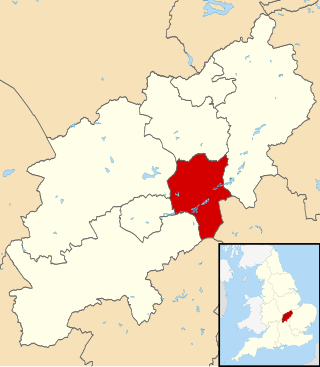
Wellingborough is a market town and civil parish in the North Northamptonshire unitary authority area of Northamptonshire, England. It is 65 miles (105 km) from London and 11 miles (18 km) from Northampton, and is on the north side of the River Nene.

Kettering is a market and industrial town in North Northamptonshire, England, 67 miles (108 km) north of London and 15 miles (24 km) north-east of Northampton, west of the River Ise, a tributary of the River Nene. The name means "the place of Ketter's people ".

Burton Latimer is a town in North Northamptonshire, England, approximately 3.1 miles (5.0 km) southeast of Kettering and 4.5 miles north of Wellingborough. At the 2021 census, its population was 10,444.
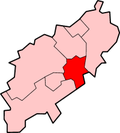
The Borough of Wellingborough was a non-metropolitan district and borough in Northamptonshire, England, from 1974 to 2021. It was named after Wellingborough, its main town, but also included surrounding rural areas.
Boughton is a village and civil parish in West Northamptonshire, England. It is situated approximately 4 miles (6 km) from Northampton town centre along the A508 road between Northampton and Market Harborough.
Hannington is a village in West Northamptonshire in England. At the time of the 2011 census the parish's population was 251 people.

Duston is a suburb of Northampton and a civil parish in West Northamptonshire, England.
Wootton is a former village about 3 miles (4.8 km) south of Northampton town centre that is now part of Northampton.

Isham is a village and civil parish in Northamptonshire, England. It is on the A509 road, three miles south of Kettering and a mile to the west of Burton Latimer. The River Ise is to the east of the village. Administratively, it forms part of North Northamptonshire. It was previously in the Borough of Wellingborough until 2021. At the time of the 2011 census, the parish's population was 772 people.
Rothersthorpe is a small village of medieval origin, in West Northamptonshire, England, with a population of 500 in the 2001 Census, reducing to 472 at the 2011 census. It is 4 miles (6 km) from the town of Northampton.

Finedon is a town and civil parish in North Northamptonshire, England, with a population at the 2021 census of 4,552. In 1086 when the Domesday Book was completed, Finedon was a large royal manor, previously held by Queen Edith, wife of Edward the Confessor.

Ecton is a village and civil parish in North Northamptonshire, England. The village is just east of Northampton, just off the A4500 road. It was one of the first villages in Northamptonshire to be given conservation status. The toponym is derived from the Old English words Ecca and tun, meaning "Ecca's farm/settlement."

Wymington is a small village and civil parish in the borough of Bedford in northwestern Bedfordshire, England. It is located about 1.7 miles (2.7 km) south of Rushden, in the neighbouring county of Northamptonshire, and about 10 miles (16 km) north-northwest of Bedford. As of 2021, the parish of Wymington had a population of 1000. The village is home to a 14th century parish church, a Wesleyan chapel, a school, and a pub. Wymington is home to numerous listed buildings, including the Grade 1 listed parish church. The village dates from at least 1086, when it was registered in the Domesday Book, though evidence has been discovered of paleolithic, Roman, and Saxon settlement in the area.
Earls Barton is a village and civil parish in Northamptonshire, notable for its Anglo-Saxon church and shoe-making heritage. The village is in North Northamptonshire and was previously in the Borough of Wellingborough until 2021. At the time of the 2011 census, the population was 5,387. Earls Barton is renowned for its remarkable Anglo-Saxon heritage.
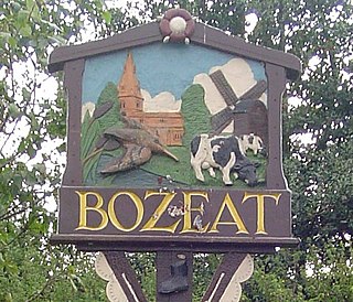
Bozeat is a village and civil parish in the postal district of Wellingborough, North Northamptonshire, England, about 6 miles (10 km) south of Wellingborough on the A509 road, near Wollaston. At the time of the 2011 census, Bozeat's population was 2,052.

Irchester is a village and civil parish in North Northamptonshire, two miles (3 km) south-east of Wellingborough and two miles south-west of Rushden. The population of the village at the 2011 Census was 5,706 and estimated in 2019 at 5,767. Little Irchester and Knuston also lie in the parish.

Hinton-in-the-Hedges is a small village and civil parish in West Northamptonshire, England, two miles due west of the town of Brackley. West of the village is Hinton-in-the-Hedges Airfield. At the time of the 2001 census, the parish's population was 179 people. It had decreased to 167 at the 2011 Census.

Little Harrowden is a village and civil parish in North Northamptonshire, England. The village is nearly 3 miles (4.8 km) north-west of Wellingborough, off the A509 road. At the 2011 Census, the population of the parish was 892.