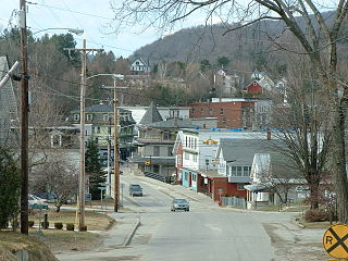
Hardwick is a town in Caledonia County, Vermont, United States. The population was 2,920 at the 2020 census. It contains the unincorporated villages of Hardwick, East Hardwick, and Mackville. The town is a commercial center for the region's farming population.

Hardwick is both a village and a civil parish within the Aylesbury Vale district in Buckinghamshire, England. It is in the Aylesbury Vale, about four miles north of Aylesbury.

Stratford-on-Avon is a local government district in southern Warwickshire, England.
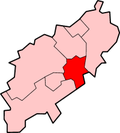
The Borough of Wellingborough was a non-metropolitan district and borough in Northamptonshire, England, from 1974 to 2021. It was named after Wellingborough, its main town, but also included surrounding rural areas.
Hardwick and Hardwicke are common place names in England—this is from the Old English pre-7th century word "heorde", meaning a "herd or flock", with "wic", which like the later Viking word "thorp" described an outlying farm or settlement, which was dependent on a larger village. In some cases, "Hardwick" and "Hardwicke" are interchangeable and the spelling has evolved over time.

The River Ise is a river in Northamptonshire, England and a tributary of the River Nene.

Rains Brook is a 11.8-kilometre-long (7.3 mi) tributary of the River Leam.

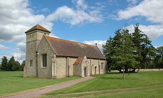
Isham is a village and civil parish in Northamptonshire, England. It is on the A509 road, three miles south of Kettering and a mile to the west of Burton Latimer. The River Ise is to the east of the village. Administratively, it forms part of North Northamptonshire. It was previously in the Borough of Wellingborough until 2021. At the time of the 2011 census, the parish's population was 772 people.
Upper Stowe is a village in West Northamptonshire in England. It is in the civil parish of Stowe Nine Churches. It has a church dedicated to St James. This was built to the design of P.C Hardwick in 1855. It has a bellcote rather than a tower.

Great Harrowden is a village and civil parish in North Northamptonshire, with a population at the 2011 census of 161. The village is located near the A509 road running between Kettering and Wellingborough. The village formed part of the Orlingbury hundred and of Borough of Wellingborough.

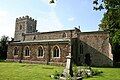
Priors Hardwick is a village and civil parish in the Stratford district of Warwickshire, England. The population of the civil parish as taken at the 2011 census was 172. The name derives from the fact that it was originally a manor belonging to the Priors of Coventry.

In architecture, a long gallery is a long, narrow room, often with a high ceiling. In Britain, long galleries were popular in Elizabethan and Jacobean houses. They were normally placed on the highest reception floor of English country houses, usually running along a side of the house, with windows on one side and at the ends giving views, and doors to other rooms on the other. They served several purposes: they were used for entertaining guests, for taking exercise in the form of walking when the weather was inclement, for displaying art collections, especially portraits of the family and royalty, and acting as a corridor.

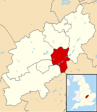
North Northamptonshire is one of two local government districts in Northamptonshire, England. It is a unitary authority area forming about one half of the ceremonial county of Northamptonshire. It was created in 2021. Its notable towns are Kettering, Corby, Wellingborough, Rushden, Raunds, Desborough, Rothwell, Irthlingborough, Thrapston and Oundle. The council is based at the Corby Cube in Corby.

Hardwick Wood is a 15.5-hectare (38-acre) biological Site of Special Scientific Interest southwest of Hardwick in Cambridgeshire. It is managed by the Wildlife Trust for Bedfordshire, Cambridgeshire and Northamptonshire.

Hardwick is a village in the civil parish of Hardwick with Tusmore about 4.5 miles (7 km) north of Bicester in Oxfordshire.
Hardwick is a village and former civil parish, now in the parish of Hardwick-with-Yelford, in the West Oxfordshire district, in the county of Oxfordshire, England. The village is on the A415 road about 2.5 miles (4 km) southeast of Witney. It lies on the river Windrush. Hardwick was historically a hamlet or chapelry in the ancient parish of Ducklington. It became a separate civil parish in 1866. On 1 April 1932 the parish was merged with the parish of Yelford and large parts of the parishes of Ducklington and Standlake to form the civil parish of Hardwick-with-Yelford, part also went to Standlake. In 1931 the parish had a population of 97.
Hardwick is the primary village and a census-designated place (CDP) in the town of Hardwick, Caledonia County, Vermont, United States. As of the 2020 census, the CDP had a population of 1,269, out of 2,920 in the entire town of Hardwick.

Hardwick Lodge Meadow is a 10 hectare biological Site of Special Scientific Interest north-west of Wellingborough in Northamptonshire.