Great Doddington

Last updated

Great Doddington
Great Doddington parish church, Northamptonshire, UK.jpg
Parish church
Northamptonshire UK location map (2021).svg
Red pog.svg
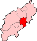
Great Doddington
Location within Northamptonshire
Population1,123 (2011)
OS grid reference SP8764
Unitary authority
Ceremonial county
Region
Country England
Sovereign state United Kingdom
Post town Wellingborough
Postcode district NN29
Dialling code 01933
Police Northamptonshire
Fire Northamptonshire
Ambulance East Midlands
UK Parliament
List of places
UK
England
Northamptonshire
52°16′18″N0°43′09″W / 52.2717°N 0.7191°W / 52.2717; -0.7191

Great Doddington is a village and civil parish in Northamptonshire, England, close to Wellingborough and just off the A45. At the time of the 2001 census, the parish's population was 1,061 [1] increasing to 1,123 at the 2011 census. [2]

The name Dodda's Tun probably refers to an Anglo-Saxon leader 'Dodda' establishing a stronghold in the strategic position overlooking the Nene Valley. Domesday Book records the principal landowner as Judith, widow of Waltheof II, Earl of Northumbria.

The Church of England St Nicholas Church dates back to Norman days and has a square tower and four 15th century misericords. The village contains a village shop, and two churches, St Nicholas' and a United Reformed Chapel.

The civil parish contains two wards. [3]

Related Research Articles

<span class="mw-page-title-main">Dunton, Buckinghamshire</span> Human settlement in England

Dunton is a village and civil parish in the Aylesbury Vale district of Buckinghamshire, England. The village is situated approximately 8 miles (13 km) north from Aylesbury and 4 miles (6.4 km) south-east from Winslow.

Great Oxendon is a linear village and civil parish in West Northamptonshire in England. At the time of the 2001 census, the parish's population was 307 people, increasing to 331 at the 2011 Census.

<span class="mw-page-title-main">Dodford, Northamptonshire</span> Human settlement in England

Dodford is a village in West Northamptonshire, England. Prior to local government changes in 2021 it was within the Weedon Ward of Daventry District. The village is just north of the A45 road 1+12 miles (2.4 km) west of Weedon. The population of the civil parish at the 2011 Census was 203. It is 3+12 miles (5.6 km) east of Daventry and 10 miles (16 km) west of Northampton. It is also close to junction 16 of the M1 motorway. The parish consists of some 1,384 acres (560 ha) and is bounded on the east by the A5 trunk road which is the old Roman road of Watling Street. Most of the village and parish sits astride the valley of an east-flowing stream which is a tributary of the River Nene.

<span class="mw-page-title-main">Turvey, Bedfordshire</span> Human settlement in England

Turvey is a village and civil parish on the River Great Ouse in the Borough of Bedford, Bedfordshire, England, about 7 miles (11 km) west of Bedford town centre. The village is on the A428 road between Bedford and Northampton, close to the border with Buckinghamshire. The 2011 Census recorded the parish's population as 1,225.

<span class="mw-page-title-main">Ault Hucknall</span> Human settlement in England

Ault Hucknall is a village and civil parish in the Bolsover district of Derbyshire, England. The population of the civil parish at the 2011 census was 1,053.

<span class="mw-page-title-main">Rickinghall Inferior</span> Human settlement in England

Rickinghall Inferior is a civil parish in the Mid Suffolk district of Suffolk, England. According to the 2011 census there were 233 males and 216 females in this civil parish, for a total population of 449. It includes the western part of the village of Rickinghall and is adjacent to the village and parish of Wattisfield. The old road from the market town of Bury. St Edmunds to the City of Norwich and the town of Great Yarmouth passes through the centre of the village but the new road, the A143, uses a by-pass to the East.

<span class="mw-page-title-main">Artington</span> Human settlement in England

Artington is a village and civil parish in the borough of Guildford, Surrey, England. It covers the area from the southern edge of the built-up centre of Guildford and steep Guildown, the start of the Hog's Back and part of the North Downs AONB, to New Pond Farm by Godalming and the edge of Peasmarsh. It contains Loseley Park, a country estate with dairy, and the hamlet of Littleton.

<span class="mw-page-title-main">Barrow, Cheshire</span> Civil parish in Cheshire, England

Barrow is a civil parish, in the unitary authority of Cheshire West and Chester and the ceremonial county of Cheshire, England. The civil parish contains the village of Great Barrow and the hamlets of Little Barrow, Broomhill and Stamford Bridge. Great Barrow is situated about 4.5 miles east-north-east of Chester, 6 miles north-west of Tarporley and 6 miles south of Frodsham.

<span class="mw-page-title-main">Bishops Sutton</span> Human settlement in England

Bishops Sutton or Bishop's Sutton is a village and civil parish one mile (1.6 km) east of the market town of Alresford in the City of Winchester district of Hampshire, England. According to the 2001 census it had a population of 419, increasing to 463 at the 2011 Census.

<span class="mw-page-title-main">Blakenhall, Cheshire</span> Human settlement in England

Blakenhall is a small village and civil parish in the unitary authority of Cheshire East and the ceremonial county of Cheshire, England, about 7 miles (11 km) south-east of Nantwich. It lies on the county boundary with Staffordshire. The parish has an area of 654 hectares and also includes the small settlements of The Den and Gonsley Green, with a total population of 125 in 2001. Nearby villages include Wybunbury in Cheshire and Betley and Wrinehill in Staffordshire. Blakenhall was first recorded in the Domesday survey as Blachenhale, and the parish had one of Cheshire's early ironworks in the 17th and 18th centuries. The area is rural and predominantly agricultural, with small areas of ancient woodland and the nature reserve of Blakenhall Moss, a rejuvenating lowland raised bog. The Crewe-to-Stafford railway line runs through the parish and it is on the proposed route of HS2.

<span class="mw-page-title-main">Doddington, Cambridgeshire</span> Village and parish in England

Doddington is a village and civil parish lying just off the A141 in the Isle of Ely, Cambridgeshire, approximately half way between Chatteris and March

<span class="mw-page-title-main">Wimblington</span> Human settlement in England

Wimblington is a village in the Isle of Ely, Cambridgeshire, England, with a population of 1700 as of the 2001 census, including Stonea and increasing to 2,211 at the 2011 Census.

<span class="mw-page-title-main">Claypole, Lincolnshire</span> Village and civil parish in the South Kesteven district of Lincolnshire, England

Claypole is a village and civil parish in the South Kesteven district of Lincolnshire, England. The population of the civil parish at the 2011 census was 1,382. It is situated 4 miles (6.4 km) south-east from the market town of Newark-on-Trent, just east of the Grantham to Newark stretch of the A1.

<span class="mw-page-title-main">Bridgemere</span> Human settlement in England

Bridgemere is a village and former civil parish, now in the parish of Doddington and District, in the unitary authority area of Cheshire East and the ceremonial county of Cheshire, England. It is around 7 miles (11 km) south east of Nantwich and 12 miles (19 km) west of Stoke-on-Trent. The southern boundary of the parish is on the border with Shropshire. The civil parish also included the small settlements of Admiral's Gorse, Parrah Green, Prince Hill, Seven Stars and Wheel Green. In 2011 the parish had a population of 148. Nearby towns include Crewe in Cheshire, Market Drayton and Whitchurch in Shropshire, and villages include Blakenhall, Buerton and Hankelow in Cheshire, Madeley, Staffordshire and Woore, Shropshire.

<span class="mw-page-title-main">Hunsterson</span> Human settlement in England

Hunsterson is a hamlet and former civil parish, now in the parish of Doddington and District, in the unitary authority of Cheshire East and the ceremonial county of Cheshire, England. The hamlet is located 2¾ miles to the north east of Audlem and 6 miles to the south of Crewe. The parish also included the settlements of Brown Moss, Four Lane End, Foxes Bank and Whittaker's Green. In 2011 the parish had a population of 163. Nearby villages include Audlem, Buerton, Hatherton and Hankelow.

<span class="mw-page-title-main">Doddington, Cheshire</span> Human settlement in England

Doddington is a former civil parish, now in the parish of Doddington and District, in the unitary authority area of Cheshire East and the ceremonial county of Cheshire, England, which lies to the north east of Audlem and to the south of Crewe. Nearby villages include Blakenhall, Bridgemere, Checkley, Hatherton, Walgherton and Wybunbury. The A51 runs north–south through the parish.

<span class="mw-page-title-main">Dry Doddington</span> Village in Lincolnshire, England

Dry Doddington is a small village in the north-west of the South Kesteven district of Lincolnshire, England within the civil parish of Westborough and Dry Doddington. It is situated approximately 5 miles (8 km) south-east from Newark, approximately 8 miles (13 km) north-west from Grantham, and just over 1 mile (2 km) to the east from the A1 road.

<span class="mw-page-title-main">Great Livermere</span> Human settlement in England

Great Livermere is a village and civil parish in the West Suffolk district of Suffolk in eastern England. It is located around four miles north-east of the borough's largest town Bury St Edmunds.

<span class="mw-page-title-main">Doddington, Lincolnshire</span> Village in Lincolnshire, England

Doddington is a village in the civil parish of Doddington and Whisby in the North Kesteven district of Lincolnshire, England. The population of the civil parish at the 2011 census was 319. The parish lies 5 miles (8 km) west of Lincoln, to the north of the A46 road, and is bounded to its west by Nottinghamshire. It includes the hamlet of Whisby, and parts of the Whisby Moor Nature Reserve.

Nicholforest is a civil parish in Cumbria, England bordering Scotland. The population of the civil parish taken at the 2011 census was 372. The parish covers an area that extends about 10 miles east to west and 2 miles north to south. The area was once an extensive forest between England and Scotland, and was a centre for commercial forestry by the Forestry Commission. Today there are still many trees, watered by the River Liddle In 1870–72 John Marius Wilson's Imperial Gazetteer of England and Wales described the landscape as:

References

  1. Office for National Statistics: Great Doddington CP: Parish headcounts. Retrieved 9 November 2009
  2. "Civil Parish population 2011". Neighbourhood Statistics. Office for National Statistics. Retrieved 4 July 2016.
  3. Statutory Instrument 1998 No. 2510