At the time of the 2011 census, the parish population was 544; the village is a popular place to live with commuters to London or Milton Keynes. It is the site of the 19th-century local uprising called the 'Battle of Grendon'. The village is in two parts, separated by a brook. The smaller part of the village is often shown on maps as Lower End whilst the higher (southern) part of the village is at the top of the (steep) hill.
History
The village is mentioned in the Domesday Book of 1086, when Grendon formed part of the hundred of Wymersley, which covered an area of 52 square miles (130km2). Here it is listed as having three hides and one virgate and land enough for nine ploughs, twelve sochmen, three mills rendering 3 shillings, along with 30 acres of meadow.[1]
There is a village folklore about drunken revellers leaving the pub in olden days trying to fish the reflection of the moon from the brook; these characters became known as "Moonrakers".[2] This story was reported by Thomas Sternberg in his 1851 book The Dialogue and Folk-lore of Northamptonshire, in which he reports that:
"...the men of Grendon go by the name moonrakers, in consequence, it is said, of a party of them having once seen the moon reflected in a pool and attempted to draw it out by means of rakes, under the impression it was a cheese!"
The village is twinned with Bois-Bernard in northern France.
Trinity College, Cambridge, and the advowson
The advowson of the church, including 12 acres (49,000 m²) of glebe land – including their common rights and village tithes, was granted in 1342, to King's Hall, Cambridge by Edward III. When Trinity College, Cambridge was founded in 1546, the advowson was transferred to the Master and Fellows of the new Trinity College. In 1780, following an enclosure act, the tithes were all reduced to a cash payment. The control of the living was transferred in 1926 to the Bishop of Peterborough.
Like many villages, Grendon has suffered from the loss of its local shop/post office after the owner sold the property on for development, following a series of raids.[3] The property is now a private home. Grendon's second local pub, The Crown Inn, was also later sold on for development.
The village has a parish church (St Mary's) which dates in part back to Norman times, and a thatched pub, the Half Moon, run by the Charles Wells brewery.
St Mary's Church
The church is built from limestone rubble with ironstone dressings. In the church are the remains, in the form of two rounded arches, of the original 12th century building. The two eastern bays of the nave arcades and the chancel were rebuilt between 1368 and 1380, with the clerestory being added in the 15th century along with the four-storey tower; the tower contains a ring of five bells, dating from 1618. The church houses a wooden framed clock which was made locally in 1690. The tower now uses a replacement made in 1970, but the original is still kept in the church as an exhibit and remains in working order.
Inside the church, on each side of the chancel there are medieval wooden corbel carvings of the grotesque faces of a nagging wife and her leering husband - they are thought to have been a local couple.
The gargoyles on the four corners of the tower represent the four evangelists:
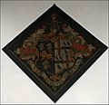
The chancel was re-roofed in around 1848. There are three hatchments relating to the Compton family - one bearing ravens represents the arms of a former Lord Lieutenant of the Tower of London.
Of the church, Sir Nikolaus Pevsner says, "The first three bays on both sides are late Norman. Next in order of time the late 12th century doorway with one order of shafts carrying simple moulded capitals and an arch with a thick roll moulding. Early 13th century the simple north doorway close to a pair of lancets. Money was left to the campanile in 1453."
Set into the floor, a 15th-century brass of an unknown and unnamed woman set between two husbands dressed in the armour of the type used at the Battle of Bosworth Field
Set into the south wall is a 13th-century piscina used by priests to rinse their hands during mass.
The outside of the church in winter
Inside the Church
The grotesque nagging wife
The nagging wife's husband
The workings of the old clock
One of the hatchments
The squint - now partially blocked
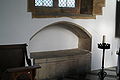
A tomb or Easter Sepulchre
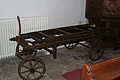
The bier
Grendon Hall
Grendon Hall
Most of the present hall dates from the 17th century when it was rebuilt by General Hatton Compton, although certain earlier parts date to the 1570s. Pevsner describes the east front as being "fine" quality. It is thought to be the work of John Lumley of Northampton.
In WWII the hall was used by the SOE as a training camp for the Free French.
Next to the present site of Grendon Hall, but on the other side of the brook is the site of a much earlier medieval manor house owned by Richard de Harrington, whose fish ponds remain today as part of the grounds of the present hall.
In 1946, after the death of the then owner Miss Mundy, the hall was sold to the County Council. The hall was re-opened by the then Princess Elizabeth in 1946.
The Old Parsonage
The house was designed by S.S. Teulon and built in 1850. Pevsner describes it as a "...picturesque Tudor with an odd lantern with cupola; handsome gabled with mullioned windows." It is now a private house.
This page is based on this Wikipedia article Text is available under the CC BY-SA 4.0 license; additional terms may apply. Images, videos and audio are available under their respective licenses.