Borough of Wellingborough

Last updated

Borough of Wellingborough
Wellingborough UK locator map.svg
Shown within Northamptonshire
Sovereign state United Kingdom
Constituent country England
Region East Midlands
Ceremonial county Northamptonshire
Admin. HQ Wellingborough
Government
  TypeBorough Council of Wellingborough
   Leadership:Alternative - Sec.31
  Executive: 
   MPs: Peter Bone
   Leader of the Council Cllr. Martin Griffiths
Area
  Total62.95 sq mi (163.04 km2)
Population
 (2019)
  Total79,707
  Density1,300/sq mi (490/km2)
Time zone UTC+0 (Greenwich Mean Time)
  Summer (DST) UTC+1 (British Summer Time)
ONS code 34UH (ONS)
E07000156 (GSS)
Ethnicity90.8% White
4.5% S.Asian
2.5% Afro-Caribbean
Website wellingborough.gov.uk

The Borough of Wellingborough was a non-metropolitan district and borough in Northamptonshire, England, from 1974 to 2021. It was named after Wellingborough, its main town, but also included surrounding rural areas.

Contents

The local council preferred to call itself the "Borough Council of Wellingborough" rather than the more usual form "Wellingborough Borough Council".

The borough covered almost the same area as the Wellingborough constituency. It was formed on 1 April 1974, under the Local Government Act 1972, by a merger of the borough of Wellingborough with Wellingborough Rural District.

The borough bordered the districts of South Northamptonshire, Northampton, Kettering, Daventry and East Northamptonshire, as well as Milton Keynes in Buckinghamshire, and Bedford in Bedfordshire.

Abolition and replacement

In March 2018, following suspension of the County Council arising from its becoming insolvent, due to financial and cultural mismanagement by the cabinet and officers, the then Secretary of State for Local Government, Sajid Javid, sent commissioner Max Caller into the council, who recommended the county council and all district and borough councils in the county be abolished, and replaced by two unitary authorities, one covering the West, and one the North of the county. [1] These proposals were approved in April 2019. It meant that the districts of Daventry, Northampton and South Northamptonshire were merged to form a new unitary authority called West Northamptonshire, whilst the second unitary authority North Northamptonshire consists of Corby, East Northamptonshire, Kettering and Wellingborough districts. These new authorities came into being on 1 April 2021. [2] Elections for the new authorities were due to be held on 7 May 2020, but were delayed due to the COVID-19 pandemic. [3]

Concurrent with these changes, the unparished area of Wellingborough was established as a civil parish and gained a Town Council. [4]

Settlements and parishes

Other than Wellingborough itself the borough included:

Political control

See Wellingborough Borough Council elections

Arms

Coat of arms of Borough of Wellingborough
Crest
On a wreath of the colours in front of an annulet embattled on the outer edge per pale Gules and Sable a Garb Or.
Escutcheon
Per pale Gules and Or five roundels barry wavy of six those on the dexter Or and Gules and those on the sinister Gules and Or the centre roundel Or and Gules per pale counter-changed.
Supporters
On the dexter side a bull guardant Sable armed and supporting an abbatical crozier Or with veil Proper and on the sinister side a lion guardant Or armed and langued Gules supporting with the front paw a currier's shave Proper.
Motto
Forward Together [5]
Badge
A roundel barry wavy of six Gules and Or ensigned with a mural crown also Or with flames issuant Proper.

Related Research Articles

<span class="mw-page-title-main">Northamptonshire</span> County of England

Northamptonshire is a ceremonial county in the East Midlands of England. It is bordered by Leicestershire, Rutland and Lincolnshire to the north, Cambridgeshire to the east, Bedfordshire, Buckinghamshire, Oxfordshire to the south and Warwickshire to the west. Northampton is the largest settlement and the county town.

<span class="mw-page-title-main">Corby</span> Human settlement in England

Corby is a town and civil parish in the North Northamptonshire unitary authority area of Northamptonshire, England. It is located 23 miles (37 km) north-east of Northampton. From 1974 to 2021, the town served as the administrative headquarters of the Borough of Corby. At the 2021 Census, the built-up area had a population of 68,164 while the borough, which was abolished in 2021, had a population of 75,571 in 2021.

<span class="mw-page-title-main">Wellingborough</span> Market town in Northamptonshire, England

Wellingborough is a market town and civil parish in the North Northamptonshire unitary authority area of Northamptonshire, England. It is 65 miles (105 km) from London and 11 miles (18 km) from Northampton, and is on the north side of the River Nene.

<span class="mw-page-title-main">Kettering</span> Town in England

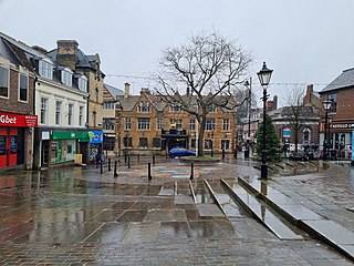
Kettering is a market and industrial town in the North Northamptonshire unitary authority area of Northamptonshire, England. It forms a civil parish called Kettering Town. Kettering is located 67 miles (108 km) north of London and 15 miles (24 km) north-east of Northampton, west of the River Ise, a tributary of the River Nene. The name means "the place of Ketter's people ".

<span class="mw-page-title-main">South Northamptonshire</span> Former local government district in England

South Northamptonshire was a local government district in Northamptonshire, England, from 1974 to 2021. Its council was based in the town of Towcester, first established as a settlement in Roman Britain. The population of the Local Authority District Council in 2011 was 85,189.

<span class="mw-page-title-main">East Northamptonshire</span> Former non-metropolitan district in England

East Northamptonshire was a local government district in Northamptonshire, England, from 1974 to 2021. Its council was based in Thrapston and Rushden. Other towns included Oundle, Raunds, Irthlingborough and Higham Ferrers. The town of Rushden was by far the largest settlement in the district. The population of the district at the 2011 Census was 86,765.

<span class="mw-page-title-main">Daventry District</span> Former local government district in England

Daventry District was a local government district in western Northamptonshire, England, from 1974 to 2021. The district was named after its main town of Daventry, where the council was based.

<span class="mw-page-title-main">Borough of Kettering</span> Former borough in England

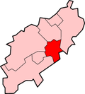
The Borough of Kettering was a local government district and borough in Northamptonshire, England, from 1974 to 2021. It was named after its main town, Kettering, where the council was based. It bordered onto the district of Harborough in the neighbouring county of Leicestershire, the borough of Corby, the district of East Northamptonshire, the district of Daventry and the borough of Wellingborough.

<span class="mw-page-title-main">Wellingborough (UK Parliament constituency)</span> Parliamentary constituency in the United Kingdom, 1918 onwards

Wellingborough is a constituency in Northamptonshire represented in the House of Commons of the UK Parliament. The seat is currently held by Labour MP Gen Kitchen, after the recall of MP Peter Bone in December 2023 which resulted in a by-election in February 2024.

<span class="mw-page-title-main">South Northamptonshire (UK Parliament constituency)</span> Parliamentary constituency in the United Kingdom, 2010 onwards

South Northamptonshire is a constituency represented in the House of Commons of the UK Parliament since its 2010 recreation by Andrea Leadsom, a Conservative who served as Secretary of State for Business, Energy and Industrial Strategy until 13 February 2020. She was Leader of the House of Commons from 2017 to 2019, and Secretary of State for Environment, Food and Rural Affairs from 2016 to 2017. The seat of South Northamptonshire is considered a Conservative safe seat, having elected a Conservative MP at every election for 110 Years. Current Conservative MP Andrea Leadsom was re-elected in 2019 with an increased majority.

<span class="mw-page-title-main">Northamptonshire County Council</span> Former local authority in England

Northamptonshire County Council was the county council that governed the non-metropolitan county of Northamptonshire in England. It was originally formed in 1889 by the Local Government Act 1888, recreated in 1974 by the Local Government Act 1972 and abolished in 2021. The headquarters of the council was County Hall in Northampton.

Redhill Grange or (Redhill) is a purpose-built settlement in Wellingborough, Northamptonshire. It is situated just north from the Redwell area in the market town and eleven miles from the county town Northampton, forming part of the district authority of the borough of Wellingborough, now in North Northamptonshire.

<span class="mw-page-title-main">Unitary authorities of England</span> Local government in some parts of England

The unitary authorities of England are a type of local authority responsible for all local government services in an area. They combine the functions of a non-metropolitan county council and a non-metropolitan district council, which elsewhere in England provide two tiers of local government.

<span class="mw-page-title-main">North Northamptonshire</span> District in England

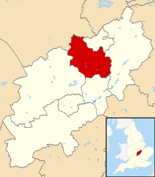
North Northamptonshire is one of two local government districts in Northamptonshire, England. It is a unitary authority area forming about one half of the ceremonial county of Northamptonshire. It was created in 2021. Its council is based in Corby, the district's largest town. Other notable towns are Kettering, Wellingborough, Rushden, Raunds, Desborough, Rothwell, Irthlingborough, Thrapston and Oundle.

<span class="mw-page-title-main">West Northamptonshire</span> District in England

West Northamptonshire is a unitary authority area covering part of the ceremonial county of Northamptonshire, England, created in 2021. By far the largest settlement in West Northamptonshire is the county town of Northampton. Its other significant towns are Daventry, Brackley and Towcester; the rest of the area is predominantly agricultural villages though it has many lakes and small woodlands and is passed through by the West Coast Main Line and the M1 and M40 motorways. The district includes the site of the Roman town of Bannaventa, and the grade I listed Althorp House and its estate.

<span class="mw-page-title-main">Northamptonshire Football Association</span> Governing body of association football in Northamptonshire

The Northamptonshire Football Association, also simply known as the Northamptonshire FA, is the governing body of football in the English county of Northamptonshire.

<span class="mw-page-title-main">Northampton Borough Council</span> Former non-metropolitan district in England

Northampton Borough Council was the borough council and non-metropolitan district responsible for local government in the large town of Northampton in England. In 2021 the council was abolished and succeeded by West Northamptonshire Council; a unitary authority, and the Northampton Town Council, a parish council.

<span class="mw-page-title-main">Grade II* listed buildings in Northamptonshire</span>

The ceremonial county of Northamptonshire is divided into two unitary authorities West Northamptonshire and North Northamptonshire. Up until 31 March 2021, Northamptonshire was divided into seven districts. The former districts of Northamptonshire were South Northamptonshire, Northampton, Daventry, Wellingborough, Kettering, Corby, and East Northamptonshire.

<span class="mw-page-title-main">Borough of Corby</span> Non-metropolitan district and borough in England

Corby was a non-metropolitan district with borough status in the county of Northamptonshire, England. It bordered the East Northamptonshire district to the east, the Borough of Kettering to the south and west, the Harborough district of Leicestershire to the north-west, and the county of Rutland to the north-east. In 2021 the district had a population of 75,571. The council, Corby Borough Council was based at the Cube in the town of Corby.

References

  1. "Northamptonshire County Council: statement". 27 March 2018. Retrieved 13 June 2018.
  2. "Northamptonshire: Unitary authorities plan approved". BBC News. 14 May 2019. Retrieved 18 August 2020.
  3. "AT LAST! Northamptonshire's new unitary councils are made law by parliament". Northampton Chronicle. 14 February 2020. Retrieved 18 August 2020.
  4. "Wellingborough Town Council information sessions". Borough Council of Wellingborough. Retrieved 18 August 2020.
  5. "East Midlands". Civic Heraldry of England. Retrieved 8 March 2021.

52°18′05″N0°41′40″W / 52.30139°N 0.69444°W / 52.30139; -0.69444