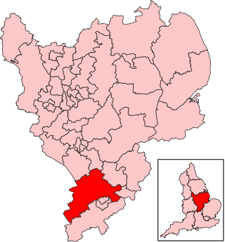
The largest town in the district was Brackley, which had a population of 14,000 in 2008,[2] followed by Towcester, which had a population of nearly 10,000.[2] Other significant settlements in size included Deanshanger, Bugbrooke, Roade, King's Sutton, Silverstone and Middleton Cheney. Many of the villages listed had populations exceeding 1,000.[n 1]
Geography
Elevations and shape
The northern half of the district was generally higher than the south, reaching 192m AOD[3] northeast of the centre of Aston-le-Walls, and 182m on the road east of Culworth, a village which also rests on top of the ridge following the general WSW line of the county and of the district but except for this is north of the district. This ridge is part of the Jurassic Way.[n 2] Lower parts are at 85m AOD (above mean sea level) in the southwest corner[n 3] and 50m (160ft) AOD in the northeast.[n 4]
The district was shaped approximately like the Christian cross in an ENE orientation extending from its top at the southeast of Northampton and reaching to a north–south line south-by-southeast of Banbury, Oxfordshire. An additional arm near its foot reached north through the large village of Chipping Warden to Upper Boddington.
Soil and geology
Land was taken up with for the most part with arable agriculture peppered by villages, however allows space for two towns of significant size. Supporting this [4] is a regular interspersion of two high fertility types of soil for most plants and crops: freely draining slightly acid but base-rich; and lime-rich loamy and clayey soils with impeded drainage soils, on a default (generally slightly lower) soil of slowly permeable seasonally wet slightly acid but base-rich loamy and clayey soils (of medium fertility). The district in terms of watercourses had sources and headwaters of the rivers Cherwell, Great Ouse and Nene.[3]
With just over 79,293 people in 2000[5] and 91,000 in 2008, a 14.8% increase.[2]
The growth in population between 2001 and 2007 was the third largest of all districts in the country and consisted of 35,700 households.[6]
The district was notable for the proportion of and growth in detached houses, and the district was one of a tiny proportion to have seen a growth in the proportion of this type of home relative to other types between 2001 and 2011.[7]
History
The Forum, Towcester: Council's headquarters from 2015 until its abolition.
The council chose to based itself in Towcester. It was initially based itself at Towcester Town Hall, which had been built in 1865 and had been bought by Towcester Rural District Council in 1935.[8][9][10] The council moved to a new building at the junction of Springfields and Brackley Road in 1982, which in turn was replaced by another new building called The Forum on Moat Lane in 2015.[11]
Abolition and replacement
In March 2018 at Northamptonshire County Council, following financial and cultural mismanagement by the cabinet and officers, the then Secretary of State for Local Government, Sajid Javid, sent commissioner Max Caller into the council, who recommended the county council and all district and borough councils in the county be abolished, and replaced by two unitary authorities, one covering the West, and one the North of the county.[12] These proposals were approved in April 2019. It meant that the districts of Daventry, Northampton and South Northamptonshire were merged to form a new unitary authority called West Northamptonshire, whilst the second unitary authority North Northamptonshire consists of Corby, East Northamptonshire, Kettering and Wellingborough districts. These new authorities came into being on 1 April 2021.[13] Elections for the new authorities were due to be held on 7 May 2020, but were delayed due to the COVID-19 pandemic.[14]
1 2 3 South Northamptonshire Council (2009). "State of the Districts Economy in 2009" base on Office for National Statistics data. Towcester: SNC. p.5.
Northamptonshire is a ceremonial county in the East Midlands of England. It is bordered by Leicestershire, Rutland and Lincolnshire to the north, Cambridgeshire to the east, Bedfordshire, Buckinghamshire, Oxfordshire to the south and Warwickshire to the west. Northampton is the largest settlement and the county town.
Towcester is an affluent market town and civil parish in the West Northamptonshire unitary authority area of Northamptonshire, England. From 1974 to 2021, it was the administrative centre of the South Northamptonshire district.
The Diocese of Peterborough forms part of the Province of Canterbury in England. Its seat is the Cathedral Church of Saint Peter, Saint Paul and Saint Andrew, which was founded as a monastery in AD 655 and re-built in its present form between 1118 and 1238.
Potterspury is a populous village and civil parish in West Northamptonshire, England. The nearest main town is Milton Keynes, the centre of which is about 7 miles south-east. At the time of the 2011 census, the parish's population was 1,453 people.
The Honour of Grafton is a contiguous set of manors in the south of Northamptonshire, England up to the county's eastern border with Buckinghamshire. Its dominant legacies are semi-scattered Whittlewood Forest and a William Kent wing of Wakefield Lodge in the body of that woodland.
Daventry is a constituency in Northamptonshire represented in the House of Commons of the UK Parliament since 2024 by Stuart Andrew of the Conservative Party.
Northampton South is a constituency represented in the House of Commons of the UK Parliament since 2024 by Mike Reader, representing the Labour Party.
Bugbrooke is a village and civil parish in West Northamptonshire, England, on a ridge overlooking the valley of the River Nene.
The A43 is a primary route in the English Midlands and northern South East England, that runs from the M40 motorway near Ardley in Oxfordshire to Stamford in Lincolnshire. Through Northamptonshire it bypasses the towns of Northampton, Kettering and Corby which are the three principal destinations on the A43 route. The A43 also links to the M1 motorway.
Old Stratford is a village and wider civil parish in the south of the English county of Northamptonshire. The population of the civil parish at the 2011 Census was 1,935. The 'Stratford' part of the village name is Anglo-Saxon in origin and means 'ford on a Roman road'. The Roman road in this sense is the Watling Street that runs through the middle of the village.
South Northamptonshire is a constituency represented in the House of Commons of the UK Parliament since 2024 by Sarah Bool. As with all constituencies, the constituency elects one Member of Parliament (MP) by the first past the post system of election at least every five years.
Deanshanger is a village and civil parish in West Northamptonshire, west-northwest of Milton Keynes. In 2007 it was joined with the civil parish of Wicken to form Deanshanger ward, returning two councillors. The population of the civil parish at the 2011 census was 3,817. Deanshanger is 50 miles (80 km) northwest of London, 5 miles (8.0 km) northwest of Milton Keynes and 52 miles (84 km) southeast of Birmingham.
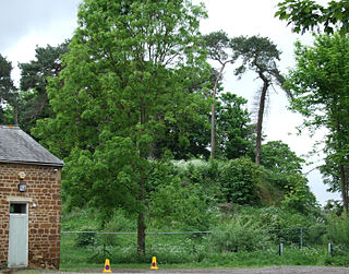
Bury Mount Motte is the remains of an earthwork motte and bailey fortification or ancient castle in Towcester in Northamptonshire, and has been designated a Scheduled Ancient Monument. The Motte probably dates back to the 11th century when it was a Norman fortification, but over time it has been subject to neglect.
Gayton is a rural village and civil parish in West Northamptonshire, England, 5 miles (8 km) south-west of Northampton town centre. The village is situated on a hill close to the larger villages of Bugbrooke, Milton Malsor and Blisworth, with a linked public footpath network. At the 2011 Census, the population of the parish was 544.
Kislingbury is a village in Northamptonshire, England, about 4 miles (6 km) west of Northampton town centre, and close to junctions 15A and 16 of the M1 motorway.
West Northamptonshire is a unitary authority area in the ceremonial county of Northamptonshire, England, and was created in 2021. It contains the county town of Northampton, as well as Daventry, Brackley and Towcester; the rest of the area is predominantly agricultural villages though it has many lakes and small woodlands.
The Elizabeth Woodville School, in Northamptonshire, England, is a secondary school with academy status, run by the Tove Learning Trust. It was formed by the merger of Roade Sports College and Kingsbrook Specialist Business and Enterprise College in 2011. It is located at two sites in the villages of Deanshanger, and Roade, both in South Northamptonshire. The merged school was named after Elizabeth Woodville, who was born in Grafton Regis, halfway between the two sites, and was Queen consort of King Edward IV.
This page is based on this Wikipedia article Text is available under the CC BY-SA 4.0 license; additional terms may apply. Images, videos and audio are available under their respective licenses.