Eydon

Last updated • 4 min readFrom Wikipedia, The Free Encyclopedia

Eydon
Eydon - geograph.org.uk - 412539.jpg
St Nicholas' parish church
Northamptonshire UK location map (2021).svg
Red pog.svg
Eydon
Location within Northamptonshire
Population422 (2011 Census) [1]
OS grid reference SP5450
  London 73 miles (117 km)
Civil parish
  • Eydon
Unitary authority
Ceremonial county
Region
Country England
Sovereign state United Kingdom
Post town Daventry
Postcode district NN11
Dialling code 01327
Police Northamptonshire
Fire Northamptonshire
Ambulance East Midlands
UK Parliament
Website Eydon Parish Council
List of places
UK
England
Northamptonshire
52°08′47″N1°12′34″W / 52.1463°N 1.2095°W / 52.1463; -1.2095

Eydon is a village and civil parish in West Northamptonshire, about 8 miles (13 km) north-east of Banbury. The village is between 510 and 540 feet (160 m) above sea level on the east side of a hill, which rises to 580 feet (180 m) and is the highest point in the parish. The parish is bounded to the west by the River Cherwell, to the south by a stream that is one of its tributaries, and to the east and north by field boundaries.

Contents

The villages name means 'Aega's hill'. [2]

The 2011 Census recorded a parish population of 422. [1]

Manor

In the 11th and 12th centuries the manor of Eydon was assessed at two hides. [3] [4] The Domesday Book of 1086 recorded that one Hugh held "Egedone" of Hugh de Grandmesnil. [3] In the 12th century Richard Fitz Wale held "Aydona" of the fee of Leicester. [4]

Eydon Hall

Eydon Hall is a stately home that was built in 1789–91. [5] It is a Grade I listed building. [6]

Parish church

The oldest part of the Church of England parish church of Saint Nicholas is the Norman baptismal font. [5] [7] A north aisle of two bays was added to the nave early in the 13th century. [5] The west tower was added early in the 14th century. [5] The north windows and (now blocked) doorway of the north aisle and the south windows of the chancel are 14th century Decorated Gothic. [7] The west window of the north aisle is late medieval, being late Perpendicular Gothic. [7]

In 1864–5 the church was restored under the direction of the Gothic Revival architect R.C. Hussey. [5] Hussey added a south aisle, extended the north aisle eastwards to four bays, added a northeast vestry, and moved to the vestry a recumbent effigy of a lady that dates from about 1340. [5] The church's other notable monument is a wall-mounted tablet in grey and white marble to Rev. Francis Annesley, who died in 1811. [7] It was carved by John Bacon the younger and it is now in the south aisle. [7] In the windows of the north aisle are some stained glass heraldic shields made in about 1830. [7]

The west tower has a ring of six bells. One of the Newcombe family of bellfounders of Leicester [8] cast the fifth bell in 1603. [9] Matthew III Bagley of Chacombe [8] cast the second bell in 1770. [9] John Briant of Hertford [8] cast the third bell in 1822. [9] John Taylor & Co of Loughborough cast the tenor bell in 1872 and the treble and fourth bells in 1981. [9]

St Nicholas' is a Grade II* listed building. [7] The parish is part of the Benefice of Aston le Walls, Byfield, Boddington, Eydon and Woodford Halse. [10]

Economic history

The 17th-century Royal Oak pub Eydon - geograph.org.uk - 186287.jpg
The 17th-century Royal Oak pub

The Domesday Book of 1086 recorded that Eydon had "a mill". [3] In medieval usage this usually meant a watermill.

The village has an unusual layout of two streets in parallel (High Street and Lime Avenue). [11] Lime Avenue now has gaps and fields between some houses on its west side, but earthworks suggest that in earlier centuries cottages were continuous on both sides. [11]

Eydon Inclosure Act 1760
Act of Parliament
Coat of Arms of Great Britain (1714-1801).svg
Long title An Act for dividing and enclosing the Common Fields, Common Pastures, Common Meadows, Common Grounds, Grange Lands, and Waste Grounds, of and in the Manor and Parish of Eydon, in the County of Northampton.
Citation 1 Geo. 3. c. 10Pr.
Dates
Royal assent 3 March 1761

Traces of traditional ridge and furrow ploughing survive in much of the parish, many in the S-shaped pattern characteristic of ox-drawn ploughs. [11] They are evidence of the open field system of farming that prevailed in the parish until 1760, when Parliament passed the Eydon Inclosure Act 1760 (1 Geo. 3. c. 10Pr.). [11]

Northwest of the village, west of Woodford Road and Manitoba Way, are 20 acres (8 ha) of shallow hollows and mounds. [11] They are the remains of small pits and spoil heaps created by the quarrying of Northampton Sand, an iron-rich sandstone, probably in the Middle Ages. [11]

In 1872 the Northampton and Banbury Junction Railway (from 1910 part of the Stratford-upon-Avon and Midland Junction Railway (SMJR)) was opened between Blisworth and Farthinghoe. It passed through the east of Eydon parish about 35-mile (1 km) northeast of the village. Its nearest stations were at Morton Pinkney and Byfield, each of which was about 2+14 miles (4 km) away.

In the 1899 the Great Central Main Line to London Marylebone was built through the same part of Eydon parish, passing about 700 yards (640 m) northeast of the village. Its nearest station was at Woodford and Hinton (later renamed Woodford Halse), about 1+12 miles (2.4 km) north of Eydon. British Railways closed the SMJR line in 1951, Woodford Halse station in 1963 and the GC main line in 1966.

Amenities

Eydon has a 17th-century [12] public house, the Royal Oak. [13]

Related Research Articles

<span class="mw-page-title-main">Whitchurch, Buckinghamshire</span> Human settlement in England

Whitchurch is a village and civil parish in the unitary authority area of Buckinghamshire, England. The village is on the A413 road about 4 miles (6.4 km) north of Aylesbury and 4.5 miles (7 km) south of Winslow. The 2011 Census recorded a parish population of 932.

<span class="mw-page-title-main">Wittering, Cambridgeshire</span> Human settlement in England

Wittering is a village and civil parish in the City of Peterborough unitary authority area in the ceremonial county of Cambridgeshire, England. The village is about 3 miles (5 km) south of the market town of Stamford in neighbouring Lincolnshire and about 9 miles (14 km) west of Peterborough's urban sprawl.

<span class="mw-page-title-main">Woodford Halse</span> Village in Northamptonshire, England

Woodford Halse is a village about 6.5 miles (10.5 km) south of Daventry in Northamptonshire. It is in the civil parish of Woodford cum Membris, which includes also village of Hinton and hamlet of West Farndon. Hinton and Woodford Halse are separated by the infant River Cherwell and the former course of the Great Central Main Line railway. The village was formerly served by the Great Central Railway, which provided significant local employment, including Woodford Halse railway station which opened in 1899 and closed in 1966.

<span class="mw-page-title-main">Lower Catesby</span> Human settlement in England

Lower Catesby is a hamlet in the civil parish of Catesby, Northamptonshire, about 4 miles (6.4 km) southwest of Daventry. Lower Catesby is beside the nascent River Leam, which rises about 1 mile (1.6 km) to the south in the parish of Hellidon. The Jurassic Way long-distance footpath passes through Lower Catesby. The population of the hamlet is included in the civil parish of Hellidon.

<span class="mw-page-title-main">Hellidon</span> Village in Northamptonshire, England

Hellidon is a village and civil parish about 5 miles (8 km) south-west of Daventry in Northamptonshire, England. The parish area is about 1,600 acres (650 ha). It lies 520 feet (160 m) – 590 feet (180 m) above sea level on the north face of an ironstone ridge, its highest point, 670 feet (200 m) at Windmill Hill, being 0.5 miles (800 m) south-east of the village. The Leam and tributaries rise in the parish. The 2011 Census gave a population of 256, estimated at 286 in 2019. The long-distance Jurassic Way footpath linking Banbury, Oxfordshire, and Stamford, Lincolnshire, passes through. The origin of the name is unclear. "Holy Valley", "Haegla's Valley" and "Unstable valley" have been suggested, with the Old English "dun", meaning hill.

<span class="mw-page-title-main">Charwelton</span> Human settlement in England

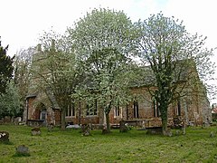
Charwelton is a village and civil parish about 5 miles (8 km) south of Daventry in Northamptonshire, England. The 2011 Census recorded the parish's population as 220.

<span class="mw-page-title-main">Thorpe Mandeville</span> Human settlement in England

Thorpe Mandeville is a village and civil parish in West Northamptonshire, England about 6 miles (10 km) northeast of Banbury in neighbouring Oxfordshire. The hamlet of Lower Thorpe is just north of the village.

<span class="mw-page-title-main">Sulgrave</span> Human settlement in England

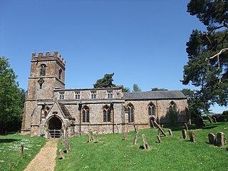
Sulgrave is a village and civil parish in West Northamptonshire, England, about 5 miles (8 km) north of Brackley. The village is just south of a stream that rises in the parish and flows east to join the River Tove, a tributary of the Great Ouse.

<span class="mw-page-title-main">Helmdon</span> Human settlement in England

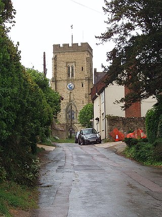
Helmdon is a village and civil parish about 4 miles (6.4 km) north of Brackley in West Northamptonshire, England. The village is on the River Tove, which is flanked by meadows that separate the village into two. The parish includes the hamlets of Astwell and Falcutt and covers more than 1,550 acres (630 ha). The 2011 Census recorded a parish population of 899.

<span class="mw-page-title-main">West Farndon</span> Hamlet in Northamptonshire, England

West Farndon is a hamlet and deserted medieval village about 34 mile (1.2 km) southwest of Hinton, Northamptonshire, in the civil parish of Woodford cum Membris.

<span class="mw-page-title-main">Moreton Pinkney</span> Village in Northamptonshire, England

Moreton Pinkney is a village and civil parish in West Northamptonshire, about 7.5 miles (12 km) north of Brackley. The 2011 Census recorded the parish's population as 371.

<span class="mw-page-title-main">Greatworth</span> Human settlement in England

Greatworth is a village in the civil parish of Greatworth and Halse about 4 miles (6.4 km) north-west of Brackley, West Northamptonshire, England. The parish also includes the hamlet of Halse. In 2011, the settlement had a population of 708. The 2011 Census recorded the parish population as 890.

<span class="mw-page-title-main">Stanton St. John</span> Human settlement in England

Stanton St. John is a village and civil parish in Oxfordshire, England, about 4.5 miles (7 km) northeast of the centre of Oxford. The village is 330 feet (100 m) above sea level on the eastern brow of a group of hills northeast of Oxford, in a slight saddle between two of the hills.

<span class="mw-page-title-main">Chacombe</span> Village in Northamptonshire, England

Chacombe is a village and civil parish in West Northamptonshire, England, about 3 miles (5 km) north-east of Banbury. It is bounded to the west by the River Cherwell, to the north by a tributary and to the south-east by the Banbury–Syresham road. The 2011 Census gave a parish population of 659 and a 2019 estimate 693.

<span class="mw-page-title-main">Culworth</span> Human settlement in England

Culworth is a village and civil parish about 7 miles (11 km) north of Brackley in West Northamptonshire, England. Culworth is also about 7 miles (11 km) northeast of the north Oxfordshire town of Banbury.

Hinton is a village about 6.5 miles (10.5 km) south of Daventry in Northamptonshire. The village is the largest settlement in the civil parish of Woodford cum Membris, the others being the village of Woodford Halse and hamlet of West Farndon.

<span class="mw-page-title-main">Radstone</span> Hamlet in Northamptonshire, England

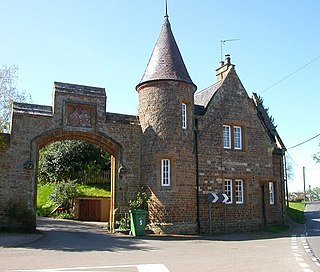
Radstone is a hamlet and civil parish in West Northamptonshire, about 2 miles (3 km) north of Brackley. The 2001 Census recorded a parish population of 54. At the 2011 Census the population of the hamlet remained less than 100 and was included in the civil parish of Whitfield.

<span class="mw-page-title-main">Chacombe Priory</span> Augustinian priory in Chacombe, England

Chacombe Priory was a priory of Augustinian canons at Chacombe, Northamptonshire, England.

<span class="mw-page-title-main">Church of St James the Less, Sulgrave</span> Church in Northamptonshire, England

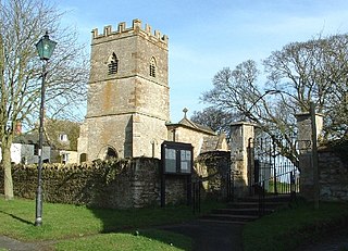
The Church of St James the Less, Sulgrave, is the Church of England parish church of Sulgrave, a village and civil parish about 5 miles (8 km) north of Brackley, Northamptonshire. The present church dates largely from the 13th and 14th centuries and is recorded in the National Heritage List for England as a designated Grade II* listed building.

References

Abutments of a former bridge on the abandoned Great Central Main Line over the minor road to Canons Ashby Eydon - geograph.org.uk - 187604.jpg
Abutments of a former bridge on the abandoned Great Central Main Line over the minor road to Canons Ashby
  1. 1 2 "Area: Eydon (Parish); Key Figures for 2011 Census: Key Statistics". Neighbourhood Statistics . Office for National Statistics . Retrieved 16 November 2013.
  2. "Key to English Place-names".
  3. 1 2 3 Adkins & Serjeantson 1902 , p. 331
  4. 1 2 Adkins & Serjeantson 1902 , p. 370
  5. 1 2 3 4 5 6 Pevsner & Cherry 1973 , p. 211
  6. Historic England (11 September 1953). "Eydon Hall (1040463)". National Heritage List for England . Retrieved 19 November 2013.
  7. 1 2 3 4 5 6 7 Historic England (4 February 1969). "Church of St Nicholas (1040476)". National Heritage List for England . Retrieved 19 November 2013.
  8. 1 2 3 Dovemaster (31 October 2012). "Bellfounders". Dove's Guide for Church Bell Ringers . Central Council of Church Bell Ringers . Retrieved 19 November 2013.
  9. 1 2 3 4 Dawson, George (8 March 2007). "Eydon S Nicholas". Dove's Guide for Church Bell Ringers . Central Council of Church Bell Ringers . Retrieved 19 November 2013.
  10. Archbishops' Council (2010). "Benefice of Aston-le-Walls, Byfield, Boddington, Eydon and Woodford Halse". Church of England. Archived from the original on 10 December 2012. Retrieved 19 November 2013.
  11. 1 2 3 4 5 6 RCHME 1982 , p. 53
  12. Historic England (4 July 1985). "Royal Oak Public House (1190417)". National Heritage List for England . Retrieved 19 November 2013.
  13. The Royal Oak at Eydon

Bibliography

Commons-logo.svg Media related to Eydon at Wikimedia Commons