
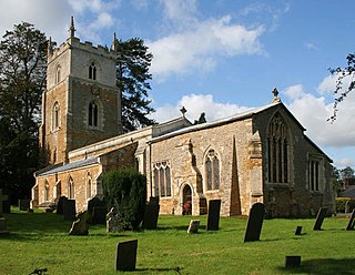
Brixworth is a large village and civil parish in West Northamptonshire, England. The 2001 census recorded a parish population of 5,162, increasing to 5,228 at the 2011 census. The village's All Saints' Church is of Anglo-Saxon origin.
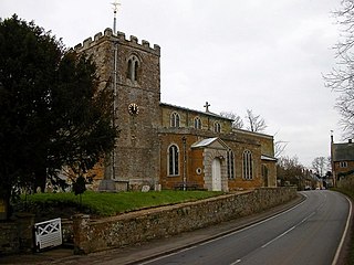
Scaldwell is a village and civil parish in the West, Northamptonshire, England.

Pitsford is a village and civil parish in West Northamptonshire in the United Kingdom. According to 2001 census, the parish's population was 636 people, increasing to 671 at the 2011 census.
Lamport is a village and civil parish in West Northamptonshire, England. The village is on the A508, about 8 miles (13 km) south of Market Harborough and 8 miles (13 km) north of Northampton. Nearby is Lamport Hall. At the time of the 2001 census, the parish's population was 207 people, including Hanging Houghton and increasing to 225 at the 2011 Census.

Cogenhoe is a village and former civil parish, now in the parish of Cogenhoe and Whiston, in the West Northamptonshire district, in the ceremonial county of Northamptonshire, England. The civil parish of Cogenhoe and Whiston had a population at the 2011 census of 1,436.

Duston is a suburb of Northampton and a civil parish in West Northamptonshire, England.

Waltham on the Wolds is a village and former civil parish, now in the parish of Waltham on the Wolds and Thorpe Arnold, in the Melton borough of Leicestershire, England. It lies about 5 miles (8.0 km) north-east of Melton Mowbray and 11 miles (17.7 km) south-west of Grantham on the main A607 road. In 1931 the parish had a population of 510. The population of Waltham on the Wolds and Thorpe Arnold was 967 in 2011.

Blisworth is a village and civil parish in the West Northamptonshire, England. The West Coast Main Line, from London Euston to Manchester and Scotland, runs alongside the village partly hidden and partly on an embankment. The Grand Union Canal passes through the village and the north portal of the Blisworth tunnel is near Stoke Road.

Islip is a village and civil parish in North Northamptonshire, England. The village is just west of Thrapston and 7 miles (11 km) east of Kettering. The parish is bounded to the east by the River Nene and to the north by Harpurs Brook, a tributary of the Nene. The 2011 Census recorded the parish's population as 829 people.

Dallington is a former village about 1.5 miles (2.4 km) northwest of the centre of Northampton, the county town of Northamptonshire, England. Dallington is now a suburb of Northampton. At the 2011 census the population was listed in the Spencer ward of Northampton Council.

Gayton is a rural village and civil parish in West Northamptonshire, England, 5 miles (8 km) south-west of Northampton town centre. The village is situated on a hill close to the larger villages of Bugbrooke, Milton Malsor and Blisworth, with a linked public footpath network. At the 2011 Census, the population of the parish was 544.
Knipton is a village and former civil parish, now in the parish of Belvoir, in the Melton district, in the county of Leicestershire, England. It lies about 6 miles (10 km) from the town of Grantham, just off the A607, and 10 miles (16 km) from Melton Mowbray. It borders the Duke of Rutland's estate at Belvoir Castle. Although the village is in Leicestershire, it has a Nottinghamshire postcode and a Lincolnshire (Grantham) STD code. In 1931 the parish had a population of 273. On 1 April 1936 the parish was abolished and merged with Belvoir.

Lowick is a village and civil parish forming part of the district of North Northamptonshire, England, about 2 miles (3.2 km) north-west of Thrapston. It appears in the Domesday Book as Luhwik, and later as Lofwyk and in 1167 as Luffewich. The name derives from Old English "Luhha's or Luffa's dwelling place", wic being cognate to vicus in Latin. At the time of the 2011 census, the parish's population was 298 people.

Far Cotton is a district in the civil parish of Far Cotton and Delapre, in the town of Northampton, in the county of Northamptonshire, England and many years ago a village in its own right.
Cranford St John is a village and former civil parish, now in the parish of Cranford, in the North Northamptonshire district, in the ceremonial county of Northamptonshire, England. It is in the southern half of the parish of Cranford, next to Cranford St Andrew - both named after the two parish churches. The two settlements are divided by the Alledge Brook, a tributary of the River Nene; the derivation of the name is "ford frequented by cranes or herons". In 1931 the parish had a population of 239. On 1 April 1935 the parish was abolished to form "Cranford".

Furtho is a deserted medieval village and former civil parish, now in the parish of Potterspury, in the West Northamptonshire district, in the ceremonial county of Northamptonshire, England. In 1931 the parish had a population of 25.

Harston is a crossroads village and former civil parish, now in the parish of Belvoir, in the Melton district, in Leicestershire, England, near the border with Lincolnshire. The nearest town is Grantham, about 6 miles (10 km) to the north-east. It once contained several quarries for iron ore. Part of the village borders Lincolnshire. In 1931 the parish had a population of 182. On 1 April 1936 the parish was abolished and merged with Belvoir.
Cranford St Andrew is a village and former civil parish, now in the parish of Cranford, in the North Northamptonshire district, in the ceremonial county of Northamptonshire, England. It neighbours Cranford St John. In 1931 the parish had a population of 142.

Easton Neston is situated in south Northamptonshire, England. Though the village of Easton Neston which was inhabited until around 1500 is now gone, the parish retains the name. At the 2011 Census the population of the civil parish remained less than 100 and was included in the town of Towcester.

Branston is a village and former civil parish, now in the parish of Croxton Kerrial in the Melton district, in the county of Leicestershire, England. It lies 1 mile (1.6 km) north of the A607 road, 7 miles (11 km) south-west of Grantham and 7 miles north-east of Melton Mowbray, on the southern edge of the Vale of Belvoir, 3 miles (5 km) south-west of Belvoir Castle. Knipton Reservoir is 700 yards (640 m) to the north. In 1931 the parish had a population of 249.

